

The weather forecast is perfect for the next eight days. Sunny or partly sunny every day with lows between 4 and 7C and highs 18-23C. Winds for a few days will be out of the south, then light for a few days, then turning northeasterly toward the end of the period. If that doesn’t say, go ride!, I don’t know what does.
The ride I’d really like to do before I lose all of my tour-built muscle and fitness is in the mountains between Mitta Mitta and Omeo. However, there is a bit of rain forecast on Wed, Thurs and Friday up that way, and I think it could still be a bit busy on the tracks (I might see 3 or 4 cars a day instead of none) since it is still school holidays. So let’s head north with the wind and into the sun instead.
I did a job interview last Thursday. It went well. But I still got the feeling they were just going through the motions with the external advert and interviews and already had the role pegged for someone within the organisation. However, I’ll need to be in phone range at least once a day to get the results from that. If I were to get the job, we’ll have to turn around and head home likely on day 2 or 3. If I don’t get the job, then we can keep riding out the good weather. Nigel’s day surgery went fine. They found the source of bleeding, fixed that and he is good to go. So I don’t have any responsibilities there. Given I wasn’t planning to look for work til mid or late May, and don’t think anything will come of the job interview, then I would be a lazy arse to just wait around and not to head out in fine weather.
17-24 April 2023
656 kms (408 miles)
Wiradjuri Country
Jindera – Pleasant Hills – Lockhart – Narrandera – Barellan – Cocoparra National Park – Leeton – Narrandera – Munyabla – Jindera
I don’t pack the night before, so by the time I gather all the gear and get loaded up, it’s 10am. I should be passing through a town each day, so I’m only taking food for evening meals, which means I don’t need to take the fiddly front fork bags. It’s just tent, rear panniers and tarp/foam pad that need to be attached to the bike. I’m not taking a towel or shampoo, or other bits and pieces, so I feel like I’m heading out irresponsibly light even with camping and cooking gear.
But, then again, if I pull out all of my camping and cooking gear, even on a long tour, everything else would fit in one pannier. It is always curious to me to see cyclists not camping or cooking for themselves and they have more than the equivalent of one pannier. What sorts of stuff are they carrying in those stuffed panniers?
So a 10am start is a bit late at any time of year, but particularly when the sun sets at 5.45pm. However, the wind should be helpful, and there’s an infinite number of places to spend the night in a road reserve somewhere, so I am not worried.
We ride up toward Walla on the Glenellen Road – one we’ve a ridden a zillion times. All the holes and cracks are still there, the same obnoxious dogs still barking at certain properties. There is one dam that I use to gauge how wet or dry the season has become. I’ve seen it empty. I’ve seen it overflowing. Today it is almost full – not something you’d usually see in April.
I head north and west and north and east on gravel roads I haven’t ridden in four years or so. I’ve ridden nearly everything up this way at least once, so I recognise some of the big old trees and remember some of the gentle dives down to creeks. The landscape is still very, very green, particularly for this time of year. With an El Nino looking more and more likely, I’m enjoying the vibrancy while it remains.

We ride for hours, and as the sun starts to get lower, I start to wonder about where I should camp tonight. I’m close to Pleasant Hills. I’ve camped there several times at the recreation reserve. Pleasant Hills has a community-owned pub open on the weekends, a primary school and a couple churches, but no real services for the traveller. There are toilets and water, though, and that is all I need. So we head there, set up camp on the far side of the oval where the sun will shine the longest, and wonder just how we managed to ride 88 kms to get here (it’s about 60 kms if you take the most direct, sealed route).


The stargazing is phenomenal tonight, the sky so deep and clear, the Milky Way seemingly the longest, creamiest gash you’ve ever seen painted across the sky. The space station sightings are all too low to sight tonight, though, and the shooting stars a bit thin on the sky. Orion is right up there, however. I like that one as it is one of the few connections I have with my family – one of only five constellations you can reliably see in either the Northern or Southern Hemisphere.
In the morning, the wind is out of the north. It is supposed to be out of the south! But, it’s a funny thing. Every single time I’ve ever ridden to or through Lockhart, the wind has been out of the northeast. And so it is again today. It ruins my thought of riding up to Galore Hill. That uplift has been my on my list forever, but the wind has always made me change my mind. And so it does again, today, for what must be at least the sixth time!
I roll up and down the clumped up hills on County Boundary Road for a bit. If you’re ever over this way, it’s a real winner. Sealed, wide, pretty much no traffic, long rollers with good agricultural views at the top of each crest.

Today, though, I turn down the road toward Osborne for a change. I think I might take Reids Lane up toward Lockhart, as I think it’s one of the few lanes I haven’t ridden. But when I get there, I’m not sure if it goes all the way through or not. Google maps, etc are not reliable for ‘roads’ like this one. So I just keep on heading toward Osborne and ride the rest of the way to Lockhart on the main road. It’s not terribly busy, the sight lines are kms long, and I only get skimmed by one car with a dangling pine tree air freshener hanging from its rearview mirror.
Lockhart is a crap town. It could be a commuter town for Wagga Wagga if it was a more attractive place. But the locals aren’t friendly, and they are currently in the process of running one of the two cafe owners out of town – the non-local. There’s little other business in town, and the parks aren’t particularly attractive. It just makes you wonder how some little towns are so shit, but a similar-sized town of the same size and distance from a major centre thrives.
If the wind had been from the south as predicted, I thought I might get closer to Narrandera today. It would have been about 140 kms in one day which is do-able, but a fair bit more time-consuming on the mountain bike than if I was riding the touring bike. The mountain bike is considerably quicker on gravel and rocky stuff, but it feels like riding molasses compared to a touring bike when its on chipseal. But with the moderate northeasterly, and my guts not feeling particularly great today (they never give me trouble riding, but the moment I return from a tour and stop that level of activity….), I decide to head out to the nearby state forest for the night.
We find a nice spot to camp near the forest boundary, in a spot that will get the late afternoon sun. We set up camp between some gorgeous old growth callitris pine and then head out for a walk to check out more of the forest. I camped here last September, but it was rainy and the mozzies ferocious then, so I didn’t explore more at the time. Today I enjoy the mix of trees – from tight regrowth stands where the pines are all wrist-size in diameter to open grassy areas selectively cut where centuries old trees still stand.


It’s still pretty wet here, and the soil moisture extends at least 15 inches. It’s the easiest, deepest and most Leave No Trace-compliant poop hole I may have ever dug! And my guts are much happier as we head to bed.
The morning brings heavy dew on the tent. The inside of the fly is soaked with condensation. I pull the fly off and hang it from a tree branch, the water running off of it in streams. With all the long grass around, my feet are going to be soaked by the time we get to the road!
I ride along an overgrown two-track that disappears from time-to-time. The long, cured grass bends forward as I push through it in places. It gets all caught up in drive train as I ride through it and the stems break away. I’ll be picking it out of the cassette for days.

I squint into the sun and enjoy the bees’ audible hum – the buzz of a thousand bees sucking out the nectar of a million blossoms on the eucalyptus box trees. The box trees were considered ‘waste’ trees, so were frequently cut down in these old forest reserves and used for firewood just to get rid of them. So I’m pleased to see some that survived and happy to see them continuing one of their ecosystem roles – supporting the pollinators.


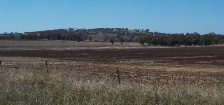
Today is a big blue sky day. They call Montana Big Sky Country, but really it has nothing on the ag areas of Oz. I can see the horizon in any direction underneath that deep blue sky. It’s like being in a snow globe that has lost its snow.

This ride is not about the scenery so much as it is about just enjoying time on the bike. There’s no grand mountains, no vast bodies of water. It’s just a sea of agriculture at a busy time of year. Everywhere we go this week, the farmers are out in the fields. They’re either burning off crop residue or sowing, or in the irrigated areas, harvesting. It’s a busy time of year and I’m likely passed by vehicles on the roads more frequently than I otherwise would be. I definitely see a lot more oversized stuff moving around – tractors, seeders, tillers, boom sprayers.
I do love being on the bike, and as I ride up through the fields, my mind frees up and I think of a million inconsequential things I won’t even remember later today. There’s many, many kilometres where I don’t think about really anything at all – I’m just feeling the road beneath me, pedalling away without any of that intense concentration needed for months in the mountains. It’s the feel of movement, freedom, physical activity, and a day that can get away from you with no consequences. It’s really the epitome of being in the moment.
This sort of landscape really is quite boring, but it’s also quite easy – it takes 130 kms of riding this to feel the same amount of fatigue as riding 20 or 30 kms in the mountains. My bike handling and touring skills and interests have long since outgrown the necessity of a ‘ride from town to town’ tour, but it does give me hope that there will be some sort of ride I can manage when I grow old and soft and need a daily resupply point. (Buddha forbid I ever get to the super soft point of WANTING roofed accommodation.)
Boree Creek has a very active grain receival point with many silos, as well as grains heaped under plastic wrap. Trucks come and go. There’s a nice little park where the council blokes are mowing the grass when I arrive. There’s a small pub where you can camp out the back. And there’s a tiny primary school. The creek is ephemeral but running today. And that’s really all there is to Boree Creek other than a community hall and multi-sided little church.


On we go along tree-lined roads. Eventually the road ceases its doglegs and becomes a straight shot north for quite some time. Pedal, pedal, pedal, over the fields we go.


At one point, a big b-double grain truck coming my way on the narrow road slows down to a stop in front of me. I stop and the driver leans out the window and says, “Hey, where are you going? I’ve passed you three times already”!
I tell him I’m heading up north while the weather is good before heading back home to Albury. He thinks that is a nice ride but wonders why I’m doing it. So I just tell him that I love riding a bike, the weather forecast was good and I didn’t have any other current obligations.
He then says, “Well, you have a safe ride, my dear. At least you are really visible. So that’s very good!”.
I thank him and head on my way. Fluoro is the way to go. No one ever comments on my 100 lumen rear light (which I’ve stopped using on sunny days since no one ever commented on it – just my fluoro – and reduces my need to charge it). I’m all for rear lights on cloudy days and when the sun is low, but sunny days maybe not so much. Fluoro though should probably be mandatory. And why would you ever knock back a safety device you can purchase for less than $10! A rear light with more than 100 lumens will set you back more than 100 bucks. It really is all about the fluoro as Nigel, the man with millions of road kms all over Oz, America and Europe, told me. Yes, he was right. For once at least…. My bright orange helmet… well, it’s starting to fade and all the sticker letters have fallen off. I probably need to replace that before the next big ride.


A hill comes into view. Straight in front of us. When I turned onto a road that had “Gap” in the title, I wondered just where this gap might be. It’s pretty flat country out here. Well, there’s a long ridge up there and the road does tilt upward. I might have to change gears. I think I’ve been sitting in the same one for the past two days. It’s been good though – I’m using the other part of the rear cassette that saw very little use in the mountains over the past few months.

Eventually we get up to some road work… with no signage or flagmen. It’s just a big grader, a sprayer and a roller in the middle of the road.

I slow down, but the guy in the water truck just motions me forward. So I work my way through a bunch of chunky dirt on the opposite side of the road to the grader (who never stops moving) and then dash over to the other side of the road before I run into the roller. Not a whole lot of compliant WHS or traffic safety procedures happening there! It makes me think of this Kermit scene below.
Our last few kms into Narrandera force us out onto the Sturt Highway. This is a major highway that connects Adelaide to points east. There’s a bit of a shoulder for me but not heaps. Luckily, everyone gives me plenty of room, even the truck who slowed a bit to let oncoming traffic pass so he could go further out and around. I know there are touring cyclists who ride this sort of road for most of their tour, but I’m super glad to only have to do it for three kilometres today!
After a big roundabout and slip lane to negotiate, we then get onto the Newell Highway, another major highway that links Brisbane to Melbourne and Adelaide. We need to get over the Murrumbidgee River and this will involve three or four bridges over the floodplain. A quick google streetview last night showed that the shoulder disappears over the bridges. I’m tensed and ready for a scary 2 kilometre dash, but just before the first bridge, I see that there is a footpath on the other side. Yippee! No stress for me. I dart over to the footpath and ride across all of the bridges on those. They are just connected by informal dirt paths in between that are littered with glass – but I’d rather slice and dice with glass than huge b-double trucks on a tight delivery schedule.
I head up to the Visitor Centre. They are more than happy to charge my phone while I go source lunch and supplies. The older women are a bit awed by my ride. The one woman can’t believe I don’t get scared being alone and keeps wondering if I’ve ever had ‘problems’. By the way she says it, I know she means ‘men looking to harass’, but I say, “No, I’ve never really had many problems with humans when they are outside of their vehicles.”
I tell her I’ve ridden at least 50,000 kilometres of touring and only been creeped out by three men in that time and easily found a way out of each situation. I don’t tell her about the locals that accused me of stealing their campsite in Montana on 4 July 2014 – that’s the closest thing to violence (the guy spit on the ground in front of me and it was a very tense situation) I’ve encountered. Now, the number of people in cars that have passed me in a dangerous manner… a lot. I’ve never bothered to count.
Narrandera is a small service town. There is one main street with shops, a whole lot of motels since it sits at the junction of two major highways, a couple of nice parks, some good walking paths along the river (which I don’t visit today) and really not much else. The town does sit on the high, northern bank of the Murrumbidgee River, so the town doesn’t generally flood (though can be cut off from the south). However, it doesn’t really embrace the river at all. You’d never really know it was a part of the town if you hadn’t crossed over it. There is a nice pool and a waterski centre down there, but it doesn’t feel like a river town like Albury or Wagga or Echuca.


After I retrieve my phone, I note that I have a message from the woman I interviewed with last week. In the phone message she just asks me to return her call. This, combined with none of my references texting me to tell me they’d been rung to provide a reference, tells me I didn’t get the job. It’s really no big deal. The pay was crap and wasn’t something I really wanted to do, even though I was very qualified – actually, overqualified – for the position. I applied just because it would be a permanent, full-time position so I wouldn’t need to juggle multiple jobs and wouldn’t need to go through all the rigamarole involved with finding a job.
I ring the lady back, but it goes to voicemail. Crap. This means I need to leave the phone on for when she calls back. It also means I probably need to stay in town tonight so I have mobile reception to receive the call…. just for the 1 percent chance she really does offer me the job. I’d hoped to sail north with the wind and camp in the road reserve along a travelling stock route north of town.
So I head over to the caravan park (it is 2 kms from town, so get your stuff before heading out there). I hadn’t planned on staying anywhere that had a shower, so I don’t even have a towel or flip flops. The unpowered sites are really crappy, though they do have a view. The woman puts me RIGHT NEXT to another caravan, even though there are heaps and heaps of open powered sites and two other unpowered sites a bit further from the caravan. The caravan people have kids and a dog, but I will get even tonight when they get to listen to me snore!

I go down to the brand new camp kitchen/amenities block (government funds for a new amenities block even though this place is privately owned (?)- maybe it’s COVID recovery money) to use the table to spread out my maps. Now that I think I know I didn’t get that job and won’t need to return to Albury, then I can plan out what to do with the rest of the good weather.
Eventually, the woman does ring. No, I didn’t get the job. No, there’s nothing different I should have done with my resume or in the interview. I was a very strong candidate, they just decided to go with someone that had more experience with their business systems. So, yeah, she didn’t say it, but that job was always destined for someone else already employed by the organisation. Never mind, maybe I can find something that pays better. I’d already decided if they didn’t offer me a salary at the top of the pay band, I would turn them down anyway.
Later, a fit-looking guy wearing a cycling tshirt comes in and asks where I’m planning to go. I tell him I think I’ve got time to go visit a national park I’ve always been interested in visiting. He asks if I’m on foot. I tell him I’m riding. He’s ridden Melbourne to Perth and Melbourne to Cairns. He’s also done Adelaide to Alice. It sounds like he’s done it in roadie vs touring fashion though, where he was really just doing day rides from motel to motel and trying to achieve the goal, rather than having a look around, camping, taking his time etc.
He used to be a professional cyclist and competed all over the world. He raced into his 60s. He’s 71 now (he only looks maybe 62!), and eight years ago he was diagnosed with Non-Hodgkins lymphoma. He was racing right up to four days up before his diagnosis, though his average speed had dropped by 8kph. The chemo and other treatments pretty much ended his career and ruined cycling for him. He doesn’t really want to dwell on it, but his sadness is very evident. It was certainly a life-changing diagnosis for him.
I ask him if he would consider an e-bike, prefacing that question by saying, ‘this may sound terrible and sacreligious, but….’. Nope. He has an e-bike. He uses it around town. His sponsor sent it to him. But he says it is just not the same at all and that he doesn’t get the same joy out of it as he does from pedalling and the effort involved in self-propulsion. I tell him I totally get it, and I have no plans for an e-bike at any time in the medium-term future. But I also say, if the choice were between an e-bike and not riding at all… I’d being doing rides that needed a charging source!
The guy is heading back to Melbourne after two months with his son in Brisbane. He has to do a blood test tomorrow and meets with his hematologist next Monday. I’m not a hugging sort of person. AT ALL. But gosh, I wanted to give that old guy a stinky hug and tell him how much I hoped the best for him. I did not offer a stinky hug, but I did offer my most sincere best wishes. You just never know what’s going to take you down. One of my uni friends recently died after his third round with lymphoma (though he was in his 20s when first diagnosed and died aged 48), so my empathy with the guy is pretty huge. His sadness at losing his identity and the thing he lived to do resonates, and I think about him for days.
The morning again brings heavy dew and condensation. I hang the tent fly off a rubbish bin, water streaming down the fly again like yesterday morning. It’s just before sunrise and it’s quite chilly this morning. I’m almost surprised that’s not frost. The BOM weather app says it’s four degrees. I wasn’t cold last night, but I do rummage around to get my gloves out of the pannier.
I work my way uphill to the north and then east into the sun through town. I squint into the sun, cross the railroad tracks and then head north on the road to Barellan. There are a few trucks that pass me in the first few kilometres. Once I get past the industrial estate though, the traffic backs right off.
We head up and over a ridge of uplifted Devonian rocks and then descend into a broad basin ringed by other low ridges. There’s a named lake off to the left for quite a few kilometres, but today it’s just a grassy depression being grazed by cows.

We eventually turn off on a road that gently drags us up past a scrubby-topped hill that’s recently seen fire through a roadside of open grassy woodland punctuated by pines. As we climb, we can gaze over to see another tree-filled depression that is obviously swampy. That, apparently, is Mejum Swamp.

We then round a small gap in the range and sail down to another broad, flat basin. Further along, and the reason I rode this road instead of sticking to the main road, we ride through a long roadside remnnant of a callitris-box woodland. It’s pine of various ages, big box trees and a grassy or sometimes shrubby understorey. It escorts us down the road toward a raised ridge jutting up separately from the main range which hides to our left behind trees.

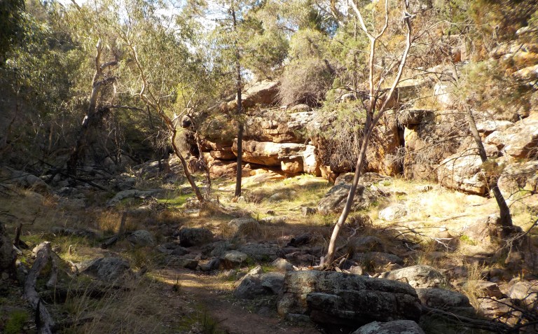
I’m loving all of the red and white Devonian rocks that outcrop as cliffs of sandstone amongst the trees. We get good views of this as we ride over and then down the adjacent uplift. Even more views arrive as we ride down the Bungabil Road back toward the main road.


For whatever reason, the main road to Barellan has very little traffic. It’s a one vehicle every 10 minutes or so road, even though it has edge lines painted most of the way. (This is how you can estimate traffic counts in Oz – if the road has centre lines it will have some traffic, and if it is wide enough to have edge lines AND centre lines, it likely has a decent amount of traffic). It’s obviously not the cut-through between east-west highways, and the residents of Barellan must go to Griffith instead of Narrandera for their shopping.
Barellan obviously had a growth spurt in the early 1900s and none before or after. There is a huge old pub down the one end of the main street (which is also the highway), some old shops set back from the highway on a frontage road, and some more one-story shops and an old movie theatre (now housing the general store) further west. That’s about it for Barellan. There’s a showground with camping, a golf course that is not much more than a shed clubhouse and unirrigated fairways, a rec reserve with pretty big, brand new footy clubrooms, a primary school and a couple small, old churches. It’s not exactly a thriving centre of activity.


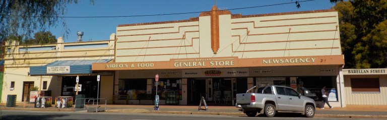


Oh, and there’s also a giant tennis racquet and ball for anyone that’s into ‘big things’. The tennis racquet was built as a way to honour Evonne Fay Gooloagong Cawley, a famous tennis player who grew up in town. The oversized replica of her signature Dunlop racquet is built on the scale of 20:1. It’s 13.8 metres from top to bottom and the tennis ball is 1.25 metres and made of fibreglass.

I go to the one cafe in town in hopes of getting a salad sandwich and supplementing those veggies with whatever I can find at the general store/supermarket. The inside of the shop is a bit messy, and I’m not sure I’d eat something from the grill or fryer. When I ask the woman at the counter for a salad sandwich, she says, “Oh, I can’t. I don’t have any fresh bread”.
Hmmm… we can both see the open loaf of bread on the counter behind her. I wonder if it was her, or a patron, who discovered the bread was mouldy? She doesn’t offer me any alternatives – like, ‘I can’t put it on sandwich bread, but I could put it in a hamburger bun.’ That would just make it a salad roll instead of a salad sandwich. But she doesn’t seem to be able to think outside the square (piece of sandwich bread). I wonder if there is a bread shortage in the whole town. She does say she has some premade chicken wraps in the fridge. I get one of those. It’s actually quite good. When I walk over to the supermarket next door, less than 10 metres away, I do note that they have several shelves of bread. Why couldn’t the cafe woman just put a sign on the door that says “be back in 5” and come over and buy a loaf of bread? I won’t be the last person wanting a sandwich today. I’m totally perplexed by her inability to solve that problem.
And the really stupid thing about it all is that I wasn’t going to eat the bread anyway. I was just going to pull the veggies off the bread to make a salad with whatever else I could find at the general store.
I go down to mail my mom’s Mother’s Day card, take a look around town and then head out to the Showgrounds to get my tent dry before the dew settles in again tonight. There’s only one caravan out there and I am able to camp far away from the powered sites. There’s a brand new amenities block (no camp kitchen), so it’s a good deal for $10.


The stars fill the sky again tonight. I can also watch the running lights along the trailers of the big trucks going by along the highway. They look like twinkling Christmas lights as they pass in and out of the shadow of tree leaves between me and the highway. But it’s quite dark otherwise and I sit out and watch the stars for nearly two hours – just taking in the shooting stars and satellites and feeling like the speck in the universe that I am.
Another chilly morning of heavy dew and condensation. Another morning of water running off the tent fly. Still, I’m away early. With such short days, early starts are a must to ensure you can see everything you want to see. My plan today is to take a gravel road instead of the main highway over to Binya. From there, I’ll head north and into the national park. I’ll then do the several short walks on offer to better see the Devonian rock outcrops before camping somewhere in or near the park tonight.
The gravel road I take (Merrimbee Road) is a hard clay with somewhat large, sharp rocks poking up in the centre. But there’s plenty of hard clay down the edge, so I make good time. Further along, the surface condition deteriorates. There is something behind me, something big which I assume is a tractor, very slowly gaining on me. I can see something big and some dust back way back there in my mirror.
Finally, an oversized pilot vehicle passes me and waves. I ride along and find a good spot where I can get off the road and then wait a couple minutes for the monster to pass me.
As I ride further along that super flat road, we start to pick up some roadside vegetation in a road reserve. Through the trees we get our first glimpses of the national park in the distance.

Then, I get passed by a large, long truck carrying an electricity pole. 10 minutes later I get passed by the big electricity work truck with the bucket arm that lifts workers to the lines. 5 minutes later I get passed by an electricity company ute with a couple guys inside. Sheesh! I took this road to avoid the traffic and I get passed by 5 vehicles in an hour!
The run turns to total crap as it turns to the north. I fight down this rocky, sandy shit for a few kilometres to the highway, immensely happy to be on the mountain bike instead of my touring bike.
I stop for a snack just on the other side of the highway near the primary school and then take the rail siding road over to a sealed road. We take this north for a bit, watching all the plumes of dust rising from tractors in many different fields where the farmers are sowing their winter crops.


We then turn off down Kites Road and start to slowly climb toward the range on a road with a few sharp turns on that super red soil. As I ride, I think of all the fun I had flying kites with my Dad as a kid. He used to build all sorts of kites, and then we would fly them in the fields near our home where they had not yet built homes. I used to love when my dad would find a piece of paper trash and put it on the string and then we could watch the wind take the trash up the string for awhile before falling off. Kite-flying and sledding are two of my favourite kid memories with my Dad. He hand-built and modified a bunch of sleds, too. Sadly, I got none of his handyman/builder skills!

After months of ascending 1000 metres at a time up to plateaus and the spines of ridges, the very gentle grade over a gap in the range nearly makes me laugh. But it’s a beautiful ride through vegetation that’s happy and had plenty of rain. The road dives between two bits of the range with steep cliffs of those Devonian rocks poking out in gently sloping lines.


I stop to do the walk to Falcon Falls. It’s a nice short walk through an open gorge. The creek is not running, so there will be no falls. A sign saying the area is closed due to nesting falcons prevents further exploration up to where the falls would be. I do go past the sign saying “Area Closed”, but only to the next interpretive sign.
A grandfather with his grandkids aged 7 and 9, which I had met back at the picnic area, are heading up. The grandpa grew up on a nearby farm so knows the place well. He lives in Griffith and his wife is working today. His daughter and grandkids are visiting from Wollongong. The daughter is ‘working from home’ today – so he’s been tasked with grandkid entertainment. I tell him it’s great he can have a relationship with them, as I very much value the time I had with my grandparents as a kid. I tell him about the area closed sign. We both agree it seems a bit early for the birds to nest. I tell him I did not see any falcons, let alone be attacked by one, so it’s probably safe to go further to the springs he wanted to show the kids. He agrees and says, “Well, I’m wearing a hat, so maybe they won’t draw blood.”

We wind on through the range and pass lots of small tracks heading off into the bush. Once I get to the 7 km mark, where the road I want takes off, I note that there is a road, but it certainly doesn’t look 2WD like the park map indicates. In fact, I’m not sure a 2WD would even manage the entry to the road if it was very wet. The road sign has poles but is missing the name bit.
I look at my various maps a bit more, then ride down the road about 100 metres. I confirm the private property starts there which means my road, which traverses the public-private boundary, is that messy and sandy one. I head down it. Even if it’s not the right road (I can’t be bothered to pull my phone out, turn it on and look at google maps), it’s at least heading in the right direction. At some point we should cross something more major, and the two walks I want to do are located on this road.
So we head up the sandy potholed road a bit and think, “Hmmmm….. maybe it was once 2WD, but after three La Ninas in a row, it is definitely not”! So I stop to take a picture of the sandiness.

But, oh my, that does not even begin to describe how bad that ‘road’ gets! The bog holes get several feet deep and much more numerous. I can see slide marks from 4WD tyres on the edges of some. Some sections where a creek has crossed the road has steep drop-offs into and out of the creek. There’s deep sand connecting some of this. There is sharp railroad ballast type rock they’ve put down in a few places. There are other areas where the road has become a creek and those bits are three feet deeper than the rest of the pot-holed road alongside. It is slow-going and very mountain-bikey. But oh my goodnes, it is so super fun! It is great fun to negotiate all the hazards, riding thin mounds of mud between potholes, negotiating rocks, branches and puddles down to where the water has so deeply incised the road, and rolling in and out of the various vehicle tracks.
After a while, as the afternoon rolls on, and none of the tracks branching off have signs, I do pull out the phone and use the satellite view to see if all the grape vines off to the left and the curve of the road looks ‘right’. Yes, I’m on the right road and can figure out where I am. I’ve still got about 3 kms to go to get to the next walking track. There is no way you’d ever get a car down that road – they really should update their “current alerts” on the website to say this, since it is an obvious road to use to connect up different parts of the park!
The road does become 2WD near the Store Creek walking track. This walking track has a really nice, shady picnic area, but they’ve blocked the vehicle access another few hundred metres up the road than it used to be, so it’d be a fair distance to drag a heavy esky or picnic basket. I can get the bike through the pedestrian gate, though, so I can leave it near a picnic table much further in and not worry about someone taking off with it from the parking area.

This is a short walk up the gorge that requires some rock scrambling at the end. It’s really nice to see the Devonian rocks up close – mostly sandstone but with some conglomerates.


We head down the road to the Jacks Creek walking track. This is a similar sort of gorge but not as long. There is a Wiradjuri family with kids running around and yelling, as they make a small shelter. The top part of the walk is closed while they stabilise the lookouts, so right now it’s just a short up-and-back along the gorge.


I meet a guy on the way back that is an obvious twitcher. Hiking pants, Columbia multi-pocketed camp shirt, hiking boots and binoculars around his neck. I ask if he’s had a good day. He says yes, and names off what he’s seen and says he’s hoping to make it an excellent day at this spot. So I say, “okay, I’ll leave you in peace then.” He just says flatly, “Thank you.” Haha! My goodness, if you don’t want to be disturbed or have people disturbing the birds, don’t sit on the side of the most popular trail in the park 250 metres from the car park!
I decide I’m going to make an early dinner here while I have access to a table and don’t have to worry about an errant bit of flame igniting grass. I had booked a campsite at the camping area tonight, but just to ensure I would have somewhere to pitch the tent. The sites are ‘free’, but the website has a $6 booking fee. That was brought in during COVID so there wouldn’t be overcrowding, but they have, apparently, just decided to keep that going. Arrghh. However, given the heaps of spots I’ve seen where I could camp on the side of stock route/road today which I would have all to myself without the sounds of children yelling and campers opening and closing or sliding their doors six million times and clanging stuff over campfires that pollute the air I’m trying to breathe…. Well, yeah, I’m not going to use that campsite booking. Besides, that’s another 8 kms of crap roads to ride as the sun sets, and I’ve seen at least four cars heading that way, so it could be cosy with the other campers (it’s just a big area, no individual camping sites).
So after a filling meal of rice, lentils, carrots, zucchini and red capsicum, I head back the way I came until I find a remarkably flat spot off in the bush near the private property boundary that can’t be seen from the road. I get everything set out to sorta dry before rapidly setting up the tent as darkness descends.


Another early start so we can get all the kms in before the sun sets at 5.40pm. I’m still in shadow, and there is a heap of smoke haze around from farmers burning stubble and weeds, but the sun shines brightly on last year’s canola stalks and glows golden against the darker background.

The road out of the park is in much better condition than the stock route road, but even this road has some sections that would not be fun in a car if it was wet!
I roll through Yenda around 9am. It’s a planned town with a central town park, like a town square. It feels very American in that way. Indeed, the man who designed Yenda, as well as Leeton and Griffith, was American and also was responsible for the layout of Canberra.
Most of the buildings date from the 1930s as the town grew with the introduction of a large irrigation scheme in the area. Most of the buildings are now vacant, as Yenda is now just a suburb of nearby Griffith. As a testament to the time of the town’s heyday, many of the buildings have an Art Deco style. However, there is a small supermarket/newsagent, and I’m able to get some gluten free gummy worms and bananas.


This town is also home to Casella wines – the makers of yellowtail. This is my parents’ favourite wine – as it is cheap and palatable to their Midwestern tastebuds. You can hear the hum from the factory all over town, and it does smell decidedly grape-like everywhere, but I don’t see any good way to get a picture of the big silos or associated buildings. The sun is not right and I don’t want to waste the time riding all over the place. But be assured, Mom and Dad, I rode right by all the big buildings on my way out of town.
For the rest of the morning, I ride through the edge of the Murrumbidgee Irrigation Area. This irrigation area grows a huge diversity of crops and 70 percent of the wine in NSW. The construction of the immense system of canals, dams, weirs and holding pools began in 1903 and was formally commissioned in 1912 when Burrinjuck Dam was finished up-river. The scheme was further expanded in the 1970s after Blowering Dam near Tumut was completed. We just skirt the edge of it but see corn, sunflowers and several crops we can’t identify. They also grow rice and cotton out here. This seems ridiculous given the climate, the overallocation of water shares and the environmental destruction that’s been caused by the river rarely having enough water to support the ecosystems reliant on it. There are some crops I think we should just import!


I get passed by more cars than I think I would, but it probably averages to one every 10-15 minutes. The gravel is all in pretty good condition, it’s pretty much dead flat, and there is no wind. So we just progress across that big basin until we reach Leeton. This town was purpose-built to be the administrative centre of the irrigation area. It was designed by Walter Burley Griffin which means it has a plethora of roundabouts and squares and no direct way to get places. It also has a heap of art deco buildings along its one long main street.


There a lot of people about, but it’s not as thriving as I’d expected. There’s a population of 7500 but still a lot of empty shops in the main street. (Maybe it’s all down by ALDI and Woolies supermarkets now – no way I was braving that area at 11am on a Saturday). The town is also the administrative centre for the local council, as well as SunRice which also has a milling and manufacturing plant. The town also has an abbatoir owned by global giant JBS, a Daily Juice company factory and an Arnotts factory. While there is definitely evidence of there being some wealthy people in town, I was surprised it didn’t feel more vibrant than it did.

We head east and south out of town and find some undulating ground for a change. We ride past huge fields (not in the irrigation area) freshly sown and crops awaiting planting. We see cattle and sheep grazing on the hillsides and land not currently in production. I enjoy climbing and falling along the gentle hills with no traffic but one big tractor for the 1.5 hours or so it takes to ride to Narrandera. On one farm we see big sheds housing a piggery. On some of the fields surrounding the piggery there are alpacas grazing. Other high-fenced fields house goats. You can’t say they haven’t diversified!


There is one final hill to climb clad in pine forest. As we crest this we come upon widely-spaced pine and lush grass off to the right. It’s the golf club, and even though I’d rather have a tooth extracted than play golf, I imagine that is quite a beautiful course to play.
We hit a dip into town and then climb gently again to the water tower hill so I can get pictures of the murals. After doing the touristy thing, we head down to the supermarket to get water (the water in this town has been crap since at least 2001 when Nigel used to overnight here on one of his runs out of Sydney – the locals don’t even drink it). I also pick up some bananas and veg for my rice and lentils tonight.


The sun is starting to get low, so I head down and ride around the wetlands. I keep my neck craned to see koalas but don’t spot any. There’s a koala reserve up-river but I don’t bother riding up there, as I need to get dinner started before dark. After nearly going extinct in the 1950s, koalas were re-introduced along the river here. The colony did very well, and you can now find them in red gums 100 kms up and down-river from here.


I rock up to the Rec Reserve. You can camp here for free, and there are plenty of carvans lining the edge of the oval – as if they are all ‘circling up the wagons’. So, I decide the illegal tent camper can just go and camp smack damn in the centre of all of them in the spot that looks like it will get the sun longest. Damn the discrimination – there’s no reason I shouldn’t be able to camp here overnight, too, since there are toilets and sinks provided.

One couple does come over to talk to me as I cook dinner. They are from Chinchilla in Queensland and are heading back toward home. They’ve driven from Yea, ‘just over the border’ today. I laugh and tell them that Yea would likely be a three-day ride from the Border for me! We wish each other safe travels.
Another chilly morning with heavy dew and condensation – the price to pay for warm, clear afternoons. I pack up and am heading down the road just before the sun crests the horizon. I ride back down that main Sturt Highway for three kilometres and then turn off on a road that heads back to the river.
We pass by the huge Narrandera Fisheries Centre. It’s got several large buildings on site and a new one being constructed. There also seems to be a bit of staff housing. It’s a research and aquaculture centre started in the 1960s. It also breeds a lot of the fingerlings stocked in watercourses throughout the state. You can tour the aquarium, but not at 6.45 on a Sunday morning.
We ride over a small hill and then cruise easterly through open paddocks. The trees weave along in the distance, tracing the course of the river. Eventually the river comes out to say hello to the road in a sharp meander.


Further along, there’s a public reserve where there are about 10 groups camping. All is quiet over there as drifts of fog laces through the trees and along the riverbank.
Even further along we pass by long stretches of wetlands in the distance. We can see white birds alighting over the clear reflective waters from a distance.


We turn south, pass more wetlands and then head east again where we eventually pick up some roadside trees to provide contrast to the fields. We pass over a creek that was an important water source in the past and then start heading south toward Galore Hill. We are finally going to head up that hill after so many aborted attempts.
And yes, the wind is from the northeast again today. But finally we have a northerly approach!


The road splits once it gets to the reserve. One road goes to the top, the other heads through the arboretum to a picnic area. I decide to head up through the trees to the picnic area first, so I can cook up some lunch. Then we’ll ride up to the top.
The reserve is nice and bushy, and it’d be nice to have a walk through the reserve just to check out the trees at a non-snakey time of year. That is not today. The picnic area, with its ‘popular playground’ is a bit disappointing. There’s a lot of erosion and weeds everywhere. The picnic tables aren’t particularly in inviting locations. There are some located on the edge of the hill that look good, but today, I need some protection from the wind for the stove.


As I’m finishing up lunch, a large Prado comes towing a gargantuan caravan up the narrow and winding access track. They have to make a few tries to turn the thing around in the picnic area. The Prado is from WA and has three kids and a mum and dad. They don’t stop, instead they just slowly lurch their way back down the hill.
I note that there is a steep, short walking path to the top from the picnic area. I decide I’ll just head up that way instead of riding to the top and meeting that, or another, massive caravan on the access road.


So I head up the hill. The views are very underwhelming, but it’s a nice little jaunt through the long grass and exposed rocks (no snakes spotted). The caravan family are standing on top of the viewing platform. They are yelling and shrieking as the kids rock and sway the small structure. Those ‘on the road’ families that take their kids out of school and do the lap around Oz often have pretty obnoxious and feral kids. These parents seem a bit loud and feral, too! It’s good to know rich people can be as obnoxious as bogans. There’s also another unhappy family arguing with each other as they set up a BBQ in the shelter as more family members arrive. And people wonder why I never wanted kids…. If that’s what I need to make my life complete, I’m very happy to go to my quiet grave missing that very loud puzzle piece!
So the views up top are very underwhelming. Lots of flat ag land and “The Rock” in the distance. After all those aborted attempts to ride up here, I guess I was expecting something a bit more exciting. Really, Morgan’s Lookout near Walla is just as nice!
We head south on a gravel road and sail along through the open fields at 30 kph with that helpful wind. I stop in crappy Lockhart to fill water bottles and buy some peanut butter and rice crackers for dinner tonight. I know where I’d like to camp, and I don’t think I’ll have too much light or desire to cook once I get there.
Then we are heading back out into the sea of agriculture and riding the waves of the Benambran Orogeny (the squeezing of rocks that formed the hills). More farmers out in the fields. More fields freshly sown.


I pick up the other end of Reids Lane that we skipped on our way up because we weren’t sure it went through. It does – but it goes through about three other names on an indirect course full of right turns. Still, I don’t think this road has been marked off on my map – if it has been I don’t remember it. I enjoy the hills and the views over the fields.
As the sun gets lower we reach County Boundary Road and continue east at that intersection. We’ve got about 30 kms to go and 2 hours before sunset. Luckily, we’ve got a long gentle downhill to a creek ahead (I’ve ridden this road many times) and I can crank it to keep the speed up over 25kph average.
We turn off toward Munyabla and have a long gentle uphill to Quarry Hill or Terlichs Hill. I’m not sure which is the correct name – but Terlichs Quarry is a gouge in the rocks at the top.

And then we are cruising downhill for the final 3 kms in a 130 km day. I’m tired, but 130 kays of this is still easier than 30 kays on rocky, steep shit in the mountains.

There are several big pieces of road equipment parked at the head of Munyabla Cemetery Lane. This is a road reserve with a rough, rarely used two-track through it that has been given over to conservation. I’ve camped in here many times.
I head down about 500 metres and find a nice spot not under overhanging branches that looks like it won’t be too lumpy. I lay the tarp, tent and fly out to see if it dries at all while I apply insect repellant and then eat a banana with peanut butter and rice crackers for dinner.
As the sun sets, I set up the tent, crawl in and feel sad that this is my last night in the tent for a bit. We’ve made the most of the good weather week and I feel good that we’ve had another week on the bike before work-sloth mode is forced back upon us.

I do have another six months of ride budget sitting there. But overseas airfares are astronomical at the moment, so I’m thinking this year’s America trip will eat up most of that. Plus, I left on this tour with a ride budget but no ’emergency funds’ budget. I had built that up to the size of a small house deposit but used almost all of it on gap fees, medications, supplements, the nutritionist consultations and other things for which Medicare doesn’t pay over the past five years.
Of course it was worth it. And of course, this was the absolute right and best time to do this tour, when I could celebrate finally being well again and having the health to get out there and ride the hardest routes I’ve ever ridden. But not having a medical or emergency fund sitting there anymore is making me nervous. Time to buckle down and work for crappy pay and conditions for a year or so to start to build that back up.
Man, it sucks to be a responsible adult. For many years, I had no emergency fund or a savings account and only got nervous when my checking account got below $1000. Now I get nervous when I have savings and checking accounts and emergency funds and retirement funds, and the checking account gets below $25,000. Yeah, it sucks to get old. But I don’t have any assets and no partner or other person to rely on, so when you are single, you are allowed to be a bit more nervous about finances.

Well, one of these days was not like the other days, one of these days just doesn’t belong. Remember that from Sesame Street?
Well, this day was not like any of the others because the tent is fairly dry when I get up around 7am. There’s a northeasterly building and it’s obviously started earlier.
I spend the first 45 minutes mostly pushing the bike down the rest of the lane. There’s a couple spots I can ride but not many. Besides, it’s the thorny time of year and there is less chance of a thorn puncture without my weight on the bike. So we walk down through the lane with its tall, shady trees and long grasses.
Then we’re heading east and south over gentle hills back to the main Henty road. That road heads southwest to the Walbundrie Road and we’re going to use it to sail the northeasterly. And this we do. No pictures as the camera battery is exhausted, and I’ve ridden this a million times. Or maybe more.
We stop for a banana and water at the GlenEllen road junction. I get skimmed by more cars between here and Jindera than I have in the entire week’s ride. Get close to a large regional centre and the drivers are so much more inconsiderate.
The highlight of the final kays home is an older woman on a road bike who catches me near the Gerogery road. She’s wearing a bright pink fluoro jersey (yay for fluoro!) and looks so healthy. She’s thin, but a healthy thin, not a compulsive exerciser thin. She’s excited about my tour. She’s never toured but done a lot of the supported Great Victorian Bike Ride types of rides. She gets out now for around 80 kms about three days per week. I could use her as my older woman role model!
She turns off at her property and I resume a slower pace. The week has dried out the fields enough again for stubble burning, and the past few days have been pretty smoky. I’ll be glad to have a couple days not having to breathe that. I will also very much enjoy that first shower soon. I’m okay with my own stink up to about six days if I’ve bucket bathed and wet wipe bathed along the way. But after day six, I’m always ready for a proper shower. And some COLD water. I texted Nigel last night to request he put some in the fridge for me.
It is only a few more kays back to Jindera. I’ve found a job I’m interested in and will need to write up all the stuff for that this week. Then we head over to Merimbula in the car to see my old neighbour and cycling friend Don for a few days before returning to Albury to seriously look for work after that.
Yep, it’s back to the domestic blah, blah, blah for a bit. I’ll start doing the write-up of each week of Unscripted – Part 2 soon.
You’re probably right about that job. A lot of places have to advertise and go through the interview hoops as they can’t just promote someone from inside. Anyway now you had the time for an Autumn ride – and it looks great. Although the tent is still wet in the morning, at least it’s not from continual rain as in the Spring. Good to hear Nigel is OK and doesn’t need further “nursing” so you can continue to alternate job hunting with cycling. It’s interesting that your guts objected to staying in one place with not so much cycling for a while. Your balance between strenuous exercise and food intake (quantity and type) must be really good but, to get back to work, another balance is to be struck. Great pictures as per usual !
Thanks, Tony. Yes, I will take a wet tent from dew over wet from rain anytime! I had eased off all of the gut support but should probably go back to taking some of them like the digestive enzymes while I adjust to less activity and different foods.
wonderfull!!!!!!!!!!!!!!!!!!!!!!!!!!!!!!!!!!!!!!!!!!!!!!!!!!!!!!!!!!!!!!!!!!!
Well good for you for not waiting by the phone at home to hear about the non-job. Great photos, gal, and a wonderful trip.
Thanks, Kathleen. Yeah, I’d gotten at least 4or 5 clues the job was already pegged for someone else so didn’t think there was any real reason to hang around waiting.
Yeah, what DO credit card tourists carry in all those panniers? I can only imagine.
Another fine bike trip and write-up. I particularly enjoyed your human encounters this time–the women at the visitor center who were concerned about your safety, the former bike racer afflicted with lymphoma, the grandpa enjoying time with his grandkids, the “twitcher” with the fancy gear, etc. Good stuff.
Yes, I was feeling peopled-out by the end of these days! I much prefer not speaking to anyone for days as I did in the mountains. 🙂
Sounds like a great trip, and a great write-up. Good luck with the job search!
Thank you! So nice to hear from you. I hope you’ve got lots of plans for summer with your Salsa. I’m so in love with mine!
Hi Em, Thanks for another entertaining tour through OZ. The “2wd” rode did look a bit scary, though. Atlas seems to have proven that a well deigned mountain bike can handle some really harsh conditions. We really like to see the town pictures. It is amazing that many old buildings are still in good condition. This ride on a broader scale looks somewhat similar to many of the farming country rail trails we rode in in Indiana and Ohio. OK…………most of the trails were paved!!! I do have a delta kite ready for flying, alas, not homemade The winds here have settled down now after a breezy spring. Your words prompted a flurry of memories of kites in the wind with you, Love, Dad
Hi dad, yes you’ve definitely moved to a place that is prime kite flying territory in spring. And yeah, Oz is pretty good about keeping old structures in use, particularly in country towns. Being out there doesn’t feel too much like Indiana though – too dry even in our wettest years. It’d be flat enough to be good rail trails though.