

4/5 August
Total kilometres: 31.5 kms (20 miles)
Total kilometres 2018: 3177 kms (1974 miles)
Day 1 – Loop from Woolshed Falls
We are predicted to have our first real spring-like day on Sunday – high of 19C and sunny. But you wouldn’t know that today. The front that came through yesterday has left low cloud and mist in its wake. Oh, it was looking like the sun would poke through out at Corowa, where it had managed 9.5C by 11am. But as we head east and towards Beechworth, the clouds close in and there is a need to use windscreen wipers on occasion. It drops to 6.5C. But we’re going to go ride in the wet anyway – because the frog and the amphibian like such weather, and I prefer it to flies and heat.
The other reason we can go get cold and wet is that I have booked a spa cabin for the next two nights. We have somewhere we can go and get warm after the ride. On Wednesday night I was looking at various motel options in Beechworth – thinking that I could do a couple day rides and base myself from there for the weekend. But when you can book an entire 1-bedroom cabin with a double spa bath for not much more than a motel room… and your tax refund just came back… and you’ve been feeling rather crappy and could do with some long spa (i.e. hot tub) sessions… well, yes, you would have booked the spa cabin, too.
We are hitting up some new roads today – picking up Malakoff, Flat Rock, Niehoff’s, McFeeters West and Byrne Gully Roads. These have been on my to-do list for a long time – though of course I had envisioned this as part of a larger ride previously. But this is about all I can do at the moment without sending myself into a bit of a relapse… so it will have to do.
I park at Woolshed Falls – a popular tourist attraction just down the road from Beechworth. It is cold and wet, so there is only one car in the lot. We pack up and roll out into the mist and only have a couple hundred metres until we can pick up our first new road.


Malokoff Road is gravel but in good condition. I suspect it can get quite corrugated in summer, but it is not bad at all today – it’s all squished and packed. There are a few sandy bits that are just like riding wet beach sand, and a few spots that have enough mud to be a bit slow.

It’s a really nice and gradual climb through pasture and slabs of granite outcrops. These long tongues of rock roll down off the plateau, interrupted by incised creeks that cut deep into the rock. There is a sense of space. You get the feeling that this landscape at this time of year would have very much reminded Irish and Scottish settlers of home.
There are very nice homes and one ramshackle property scattered along the way up. We have to cross one small creek, but the creek bottom is a granite slab, so it rides just like a causeway. From here, the climbing gets a bit steeper and meets up with some remnant forest on the left. The road curves and winds its way up through the trees with good views to the ridges that line the Woolshed Creek valley.


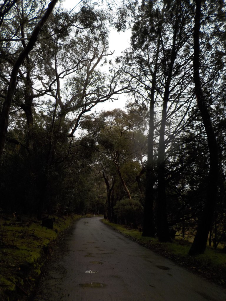
We ride past more rich people homes and then make it to the pavement. The mist seems to have let off a little – the water is not dripping from my helmet. I stop to take off a layer and then on we go – climbing higher and looking down into the dents of the creeks and the forested hills of the national park. The views would be better on a sunny day, but I am not complaining. There are no flies, no magpies and no heat – except that coming from my body.

I check on the guys in the pannier – they are doing fine and neither of them are rubbing paint off their eyeballs by vibrating against anything hard. Yes, I am such a good keeper of stuffed animals. They’ll come out of the pannier when we hit the national park and the mist has completely eased.
We climb past the prison. It’s a minimum security place with no fences – where white-collar criminals are sent and low-risk guys serve the last of their sentences. It’s a collection of various buildings and cottages, paddocks with cows, and one very large bird aviary. I think they have the guys work with the birds of prey as rehab. This same prison sends out groups to rebuild farmer fences after bushfires. It seems like one or two guys ‘escape’ each year – they are always found back home with friends or family. Stupidly, they always seem to do this really close to the end of their custodial sentence – country life is just too much for some, I guess?
Just past the prison, the road turns to gravel again and we fly along downhill through various-sized trees. We round a corner at a creek, and the road begins a long, gentle climb through more open paddocks and long views. Flat Rock is a commanding presence in the foreground – a huge outcrop of granite that is partially bald about the top but clothed in scraggly vegetation like a skirt about the base.


We roll up and around the rock – just gently spinning slowly on that soft and sandy road. As the road curves right and we meet up with the Sibelco property (silica/sand mine that supplies to the glass industry), we ride beneath a row of huge, old pine trees. The smell of damp pine takes me back to a hundred hikes in Colorado where we climbed a mountain early in the day, got back below treeline by noon and then hiked the final miles back to the car in the wet trees soaked by afternoon storms. Scent is a transporter, and for a few moments I’m 21-years-old and at 9,000 feet in Colorado.
We now meet up with Sheep Station Creek Road. When I rode this late last summer, it was dusty, corrugated and rough. With not too much rain this winter, but enough moisture to pack all the loose stuff, it is a pretty smooth and fast ride today. All the corrugations are smoothed out and there is a packed tire line to follow most of the time. Good stuff. We fly along through the dense trees along the roadside and peek through to open, granite-speckled pastures.
Somehow, coordination is with me today, and I’m able to unlatch the gate chain, open the gate, roll the bike through, re-catch the gate and relatch the chain all in one go and with one hand. I could almost be a farmer – though I’m sure had someone been around to watch me, I would have had to lay the bike down at least twice and go running after a swinging gate to catch it!
This is the first farm I’ve seen where there is no supplemental feed out for the cattle. It’s ironic, because this is the property where I had the long chat to the farmer back in Feb/March when he was out dropping hay. That farmer had told me that day that he thought winter was going to be very dry – I wish I would run across him today to ‘congratulate’ him on his accurate forecast.

I don’t see my farmer though – just the cows. The next gate is lifted onto a concrete block. I need both hands to lift, swing and re-lift, so it’s not quite as smooth going as the first. Following this, we climb to the top of a hill that would normally have great views up to Beechworth. Then it’s another downhill to the final property gate.

We ride along the edge of the property on the track/fire break on the national park side of the fence. My map shows the CFA track as connecting to the road down by the falls – though the sign at its turn-off says “No Through Road”. Maybe that’s just for vehicles, and it is passable on foot and bike, but I don’t have the energy to investigate, lose elevation and then have to re-climb to the top of the plateau.
So we take off down Niehoffs Road. And I do mean down. We are dropping off the plateau and back down to Woolshed Creek. We pedaled up in about 10 or 11 kms, but we’ll go down in about four. The first part is not too steep, and the native cypress pine provides a pleasant backdrop. The mist is all gone now – and the sky is just a light overcast.

We drop on down and go through a couple tight curves. The road has washed out in a few places and they’ve just dropped some big aggregate down on top, so this is a bit rough and rocky. And I do walk the very steepest bit for a couple hundred metres. My rim brakes and arthritic fingers aren’t enough to be able to stop us. The track is only a bit more than a car-width wide, and I can hear motorbikes somewhere in the distance, so I’m not keen to be out-of-control when there are other road users I could potentially meet.

We then drop on down through low, scraggly veg and large, rounded granite outcrops and then find ourselves at McFeeters Road West. There’s another gate to get through and yet another tiny Council Road that very much feels like someone’s driveway (it is, it just happens to continue on through the property, too). On we roll. There are properties tucked back in the bush here and there – some in better condition than others, some visible from the ‘road’, some not. We are at the base of the Woolshed Range here – its scraggly slopes rising above us on the right and the gentle flats leading to the creek on the left. This would be a terrifying place in a bushfire.

The road winds along with no major climbs or falls. There are large slabs of granite in places. We finally make it around to the creek. I’m hoping for a low flow over the causeway – normally late July/early August would see me avoid major creek crossings because they’d be flowing pretty high. Not only would that make it more difficult to cross, but it also means that the water would be high enough to get your feet (or more) wet. When it’s only 8C, that’s not very appealing.

The causeway is only running about 6 inches deep in the middle, and the concrete beneath is not mossy. So we roll across like it’s just a long, moving puddle. I stop on the other side for a snack and habitat break for the guys. Up at the top of the hill, this road – Byrne Gully – meets up with the Woolshed Road. Back in the gold rush days, there was a pub on that corner, but it burnt down in the late 1800s in a bushfire that came over the hills from Everton. Down on the creek are the remains of some public baths, though the original ford on the granite is covered over now.


This whole area was a haunt of the Kelly Gang (Australia’s most notorious bushranger). They hid out in the area, and they recruited Byrne and Sherritt from properties along this creek. There were shootings and metaphorical backstabbings and a whole lot of gossip-producing antics that happened in this valley. There are a bunch of historical plaques dotted along the valley that tell the history of the area. Of course, it’s not Roman ruins or anything dating to medieval times, but it is interesting nonetheless. The indigenous history is notably absent, however.


We head back upstream on the Woolshed Road. This road has been in terrible condition the two times I’ve ridden it previously. It would be terrible again today if the dampness wasn’t holding it all together and the millions of corrugations hadn’t been somewhat smoothed out over winter. There’s always a fair bit of traffic on this road, too, for something that’s gravel. I see four cars in six kilometres on a crappy day in winter. Out of the 31.50 kms I ride, I’ll only see five cars in total.
The road follows the creek – there’s another ford to cross , but it’s dry. You can see the extensive hydraulic sluicing they did along the creek and its tributaries as you ride along. There are long mounds of earth and deep depressions, piles of rock and lopsided lumps. Trees of various ages have regrown over it all, but it is obviously a very disturbed landscape. There’s a brief bit of history and info about the area here in this wiki: http://kellygang.asn.au/wiki/Woolshed
There are a couple of short, sharp climbs from the creek up onto the sluiced floodplains but soon enough we are rolling back into the parking lot. There are about eight cars there now. The sun is trying to pop out (it never will this day).
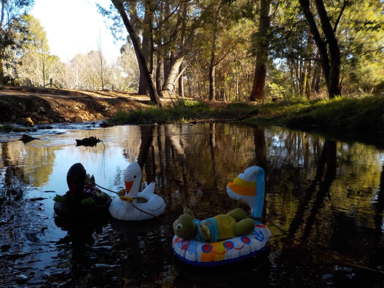
So I unload the bike and take the guys for a float at the top of the falls. We don’t get too crazy. They just float about in a backwater eddy. It would be very easy for them to get in the main flow, go over the falls and never be seen again. I don’t have the emotional capacity for THAT at the moment! It seems like every year someone is playing around in these pools above the falls, and then slips, goes over the falls, and ends up on a ledge or in the gorge below. They always have to winch them out by helicopter – so better safe than sorry.


And sorry I don’t go over to the viewing platform to get you a picture of the drop of the falls. I have done this for you before, so either search this site for “Woolshed Falls” or do a google search for Woolshed Falls, Beechworth, Victoria. The flow is very unimpressive today anyway!!
After our float, we head into Beechworth and check into our spa cabin. It’s very clean and tidy – just perfect for a couple – too small for a family. I crank up the heat – it’s only 9C outside and there’s no insulation. I’m damp from the ride, so let’s get warmed up!
Soon, we are lounging on a very soft couch with our feet up. We’ve got cheese, crackers and wine. Dinner will just be a salad I brought along from home with a cup of soup. We relax in the spa throughout the evening. It’s just perfect! I’ll do this again next winter if they run a similar deal.


Day 2 – 15 kms of walking
The nice thing about having a place for two nights is that you can get up whenever you please and not have to worry about checking out. I feel all the twingy stuff in my calves, which I now know means “Stop. Don’t do any more. You are at the limits of fatigue.”
So, instead of another ride with 550 metres of climbing that I have on my list, we go for a gentle bushwalk from town up to Lake Kerford – Beechworth’s water supply. The walk follows Hurdle Creek upstream through some nice but sluiced riparian habitat and then through open forest. It’s a very pleasant walk, though nothing remote or wilderness-y. It is perfect for the day though. It is quite windy with the warmth – so a bike ride would have been tough today, even without the fatigue. Still, we walk about 15 kms today – so much for taking it easy!


On our way back, we walk by Lake Sambell. There’s a playground and sandy beach and easy entrance to the water. The guys would love a float, but it’s windy and there are a lot of kids around – so we just do a float in the creek instead. Beechworth is absolutely nutso these days on the weekend – and the wealth is transforming this town. I much preferred its vibe 12 or so years ago.

So I don’t spend long in town – though you should have a good look around if you’ve never been here before. The streetscape is largely intact and there are many impressive public and private buildings from the gold rush era. The old Mayday Hills asylum does Ghost Tours at night, and by day, you can stroll through the expansive gardens on the grounds. It really is a very interesting town with tons of activities – if you don’t mind a pretty snobby vibe these days.
More relaxing in the arvo, more time with my feet up (it helps get that lactic acid out of my legs), more spa sessions. It’s been a perfect weekend. I do not feel rejuvenated or more refreshed after all of this, but I do feel more relaxed. Some day, when I’m well again, I’ll look back at this time and marvel at how little energy I had and how soft and unfit I’d become. But until that time comes, we’ll keep taking it easy….