

Stratford – Mitchell River National Park: Dick’s Knob and other roads that go up
Sunday March 26, 2017, 48 miles (77 km) – Total so far: 427 miles (687 km)
It’s still dark when I wade through the extensive dew to the amenities block. My feet get as wet as if I’d splashed through a creek. The water rolls off the tent as I pack it up.
The only other people moving about are the couple a few sites down that had a strong and loud disagreement late into the night about their responsibilities to each other. They don’t seem to be much happier with each other this early morning. I can’t imagine saying the things they said to each other to anyone I love, let alone at loud volume in a caravan park. Nevermind, I’ve been fortunate never to know such acrid hatred with anyone I’ve ever loved.
Now, let’s go see some rocks! Today we are going to go see the type section for the Avon River Group from the Devonian! Woo-hoo! What the heck does that mean, you ask? Well, it means we are going to see the rock exposures that are the reference set for that period of time. In this case, the rocks represent the period from about 420 to 370 million years ago – the Devonian. However, this type section is most famous for its late Devonian (younger) rocks. (I’m a bit partial to the Devonian because it is when the first ferns, seed-bearing plants and trees appear in the fossil record.)
I get inspiration for touring routes from maps, but I also scan the website below to check out sites of geological significance. The page below explains what we are going to see today. If you had any question about my nerdiness, I think we have just confirmed it. Again.
http://vro.agriculture.vic.gov.au/dpi/vro/egregn.nsf/pages/eg_lf_sites_significance_8322_8
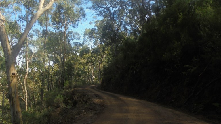
We set out as the sun reaches for the horizon. It’s 7.20am, and the sun still hasn’t crested the edge of the earth here. We’re so close to the end of daylight savings. We cruise through Stratford. I pass a guy I think is a touring cyclist – albeit one that has been on the road for awhile. I nod my head at him, but neither of us make a move to chat.
And then it’s on through the rolling plains to Briagolong. They’ve grown various things – hops, tobacco, trees, grains, dairy – over the years. Before that, it would have had extensive stands of red river gums. There is one homogenous stand of these in a reserve not far from Briagolong.
The town is a bit bigger than you might expect. It grew with the gold mining upstream and as a rural centre. A rail line allowed dairies to expand for some time, but the branch line closed in 1952. There are still a number of businesses and public infrastructure, plus plenty of newer homes. However, we just roll right on through.
The road starts to climb and we head up into Freestone Creek. The road remains paved but narrow all the way to the Blue Pool. This is a very popular camping site and swimming hole. There are heaps of people there this morning – all just starting to stir and revive campfires left smoldering overnight. The area looks tremendously overused and not all that attractive for camping to me, but I seek other attributes, I guess.
The road then climbs to a bluff where you can look down over the Blue Pool – a deep waterhole between cliffs. At other times of year, the water must flow well, but late autumn sees a lot of fairly stagnant, disconnected pools of water all along the creek. The road has great views down into the gorge and all the little pools all the way up to where the road turns up Sportsman’s Creek.

This area was the site of an alluvial gold rush in the 1860s. The geologists of the day did not think you would find gold in late Devonian rocks, so it was a surprise when gold was found in Freestone Creek and other surrounding feeder creeks. Mines and small towns were established throughout the area in the 1860s. There is now a walking track (I pass trackheads numerous times) that connects up all this history. If I had more time, I’d love to explore the Lee’s Creek area. See the link below for more information.
http://www.maffra.net.au/track96/index.html
There are some burly, dirty men parked at the bridge where the Gladstone Creek (one of the good sources of gold back in the 1800s) feeds into the Freestone Creek. They’ve got all sorts of equipment set up down in the creek bed, ready for a day of prospecting. Boy, that’s going to be noisy later!
One man is about to cross the road as I pedal by. He says, “You are doing it the hard way. The road isn’t very good up ahead. But you look intrepid. Good luck.” I smile and say, “Yeah, thanks.” In my head, I think, “Yeah, you are doing it the hard way, too. There’s easier ways to make money than tearing up a stream looking for minute quantities of gold.” Ha! To each their own – I do understand it is as much about the thrill of the hunt as it is about the yield.
Now we cross into our late Devonian rocks (we are heading back into time into older rocks as we head upstream). Hee, hee – nerds get excited! The road crosses white rhyolites from the Mt Wellington group. That weathers to a decent surface. Cliffs edge the road as we climb high above the gorge. Then the road twists, turns and drops and we are close to the creek again. This is a gorgeous ride if you don’t mind dry sclerophyll vegetation as the cover.


We ride back into the Moroka Glen formation – more colour and less ashy, chalkiness in the rocks. This is just superb fun and the most winding road you could ever hope for. We left all the traffic behind after the road got a bit rockier. Still, the campsites and picnic areas all look pretty over-used, and you wouldn’t want to drink the water from the pools.
After McKinnon’s Point, the road goes to shit for a few kilometres. It is incredibly rocky and rough. Lots of little slabby, sharp rocks make you question why you wanted to ride this road. It is tough, slow work. There’s a reason for this, though. You’ve just crossed out of the Devonian and back into the Silurian. Those shales and mudstones flake and peel off into rocky, rough stuff. It’s the same sort of rock we pushed up to Mt Samaria. It was all deposited in a shallow sea just off the continental margin 420-440 million years ago.

Oh, this is so much fun. Eventually, the road comes good again as we pass further back into time to the Ordovician (455-485 mya). This part of Victoria was under a deep ocean at the time. These rocks are not nearly so slabby and rough.
After we cross the Winkie Creek Road, the road begins to climb. It’s gradual and it follows Sportsmans’ Creek which branches off from Freestone Creek. Just before this intersection, there’s a 2 kilometre section of creek that has volcanic dykes scattered about. These rocks are much younger in age than their surrounds (Jurassic). I can’t pick them out from the road as I ride, but they are there if you want to explore.

I think this end of the road is even more scenic that the first part. The vegetation isn’t so dry, and some sheltered pockets even support tree ferns. Up and up. We climb and climb. This would sorta suck in the afternoon on a hot summer day, but today it is just fabulous.
We climb and climb and round each blind corner to more great views. I hear some 4WDs coming from the opposite direction, so I pull over to get out of the way. There’s three of them, with tons of crap piled on the roofs. They come flying around the corner – good thing I wasn’t another vehicle. It’s such a narrow road, with every curve pretty much blind, that it is totally irresponsible to drive like that. Sheesh.
Up and up. This is good stuff. A bit further on, I hear more vehicles. I’m on a straight stretch high above the creek next to a cliff. The first 4WD slows next to me and the guy flatly says, “There’s 5 more coming. You’ll want to stay out of the way.” Yeah, thanks, that is a nice way to talk to someone. The crusty, older guy in the next 4WD glances at me and says, “‘Ow ya goin’, luv?” as he passes. Ugh. How can anything sound so patronizing in just four words? The rest of the 4WDs in the group don’t bother to slow down or acknowledge me, or acknowledge that I have pulled way over on a steep drop-off for them. I know there are good 4WD people out there, but I seem to only come across arseholes. And what is up with 6 blokes needing 6 vehicles – each absolutely full of gear inside and with gear covering the roofs? Can’t you share some stuff? Do you ALL have to drive? Obviously, my mindset is on a completely different branch of the outdoor adventure tree!
On up we go. We start to get good views out over the ranges and the various knobs (little conical hills). There are a lot of pointy knobs in these parts. I pass another two guys in 4WDs pulling camper trailers who don’t bother to slow down or lift a finger in acknowledgement. Blech. But at least I’m glad I’m not camping somewhere peaceful when they all rock up in a big group.

We finally crest the range where the Budgee Track and the Daveys Knob Road branch off along the ridge. For a moment, I think about taking the Daveys Knob Road over to the Dargo Road. But then I change my mind. (I should have gone with my first instinct, but I don’t know this yet.)
Instead, we head down again, rolling along a good surface through open trees and tall forest. A bazillion little black skinks keep darting across the road in front of me. It’s like little chipmunks or prairie dogs that make last minute dashes across roads in the western US. But here it is tiny skinks. This goes on for kilometres. I say out loud, “Okay. If you guys stay still, I can weave around you. But if you keep that up, I’m taking no responsibility for any squishings!” Luckily, I think most are speedy or agile enough to avoid my tires.
We roll out at the bottom. Decision time. Do I go up to Dargo and then ride the Jones and Engineers Roads into Bruthen? Or do I go check out Mitchell River National Park and head to Bruthen via Bairnsdale? Really, all of those arsehole 4WDs have already made the decision for me. I don’t want to deal with them. And reports are that they are swarming other tracks out of Dargo (I think I may have just seen this) because so many tracks to the west of Dargo are closed due to fires or downed trees. There are likely to be more 4WDs than my tolerance threshold can handle on the Jones Road.
So I head toward Mitchell River National Park instead. The Dargo Road climbs and falls through tall forest. I see two gigantic monitor lizards – one on the side of the road and one scurrying up a large tree. Good stuff.
But then we get to the Angusvale Road. From here, the road climbs, sometimes a bit steeply, for the next 4 kilometres. As I’m crawling up, I keep telling myself, “Stupid, stupid woman. If only we had gone down (on) Dick’s Knob, we wouldn’t be in this position now.” Hehehehehe. It’s juvenile humour. But that is all your mind can come up with when you are flogging yourself up a hill in the sun.
Yes, back there we got up to the top of the range, decided against the Knob Road (it is actually Davey, not Dick, but I couldn’t remember at the time), went down the Freestone Creek Road, lost all of the elevation we gained and now get to climb back up to where the Knob Road comes out. Silly me. In my defense, the map I was using did not have topo lines (the direction the creeks flowed should have been a clue, though).
Once we have finally grunted our way up that scenic leg-buster, there’s a good downhill and then more uphill as we roll out into private land. It’s all steeply rolling hills with long views. We turn off on the Wallers Road just ahead. It is in poor condition – very corrugated and with lots of big rocks in the clay. Then we head down Dunbars Road to the Echo Bend Camping Park. I have to get off the road for several caravans, and then I have to walk parts of the road that are just too steep and rocky. It is faster to walk than to try to weave through all the huge rocks mixed in the clay.
The camping park is excellent though – an open area tucked down in the hills that is part of a working farm. They have some onsite caravans, a small log hut which sells cold drinks (much appreciated!), and the most peaceful setting you could ever hope to enjoy. It’s worth that awful road. There is one caravan group there, but there is tons of space to pitch the tent in a quiet spot. $15. I set up the tent at the back of the dam.


We then head off to do the walks in the national park. The camping park shares a boundary, so they’ve whacked a connector track into the bush. The way to do this is to turn right at the junction. Head out to the bluff overlook. Then go down to the river. Go for a swim, or dunk your shirt like I did. Then head upriver, then up the creek. This will take you up to the Den of Nargun. From there head up to the carpark, but turn left to head back to the campground’s connector track. It’s a nice loop – and I think this direction is the best to see the changes in vegetation as you descend/ascend the bluff.

I’m mostly a rock nerd, but I’m a bit of a plant nerd, too. This park is on my list because it has dry temperate rainforest on the gorge slopes, and warm temperate rainforest in the sheltered gullies. Plus the dry rainforest supports one of my favourite trees – the kurrajong. It looks a bit more like a European tree in shape and bark texture, and its leaves always stand a glossy green against the pale green of the eucalypts.
The guys enjoy the river and the rounded, river-carved rocks while I enjoy looking at the different rock types in the cliffs opposite. After dunking my shirt we head up one those rugged and deeply incised creeks to the Den of Nargun. The coolness in the sheltered gully is amplified by all of that transpiration happening from the ferns and the fleshy leaves of the wet temperate rainforest plants. It is such a contrast to the dryness on the slope above as you ascend the bluff once again.


I spend about two hours enjoying the park. I wish I had more time to head up to other parts of the park. There is a walking track along the river, through the park, that would take a couple days. There are other bluffs to explore. It’s this sort of thing that makes me feel so sad – all these places I want to spend more time but not the time to spend it. It feels so bad to say goodbye when you don’t even know fully what you are having to say goodbye to!
Back to the campground and I eat properly for the first time today. I finish the last of the freakin’ fruitcake that I’ve been toting around since the beginning of the trip. I cannot tell you how happy I am to be done with it. I don’t eat it in my normal life – but I find it a good energy source on bike trips. But, good god, that thing has lasted forever and I’m sick of eating it. No more fruitcake on this trip.
The guys enjoy chasing the ducks on the dam. I enjoy a hot shower. It has been a terrifically nerdy day and I felt strong on all of the climbing – even the unnecessary climbing back up to Daveys Knob. We’re back in the groove once again. If only we had more time to explore, more time to think, more time to ride, more time to make all the wrong things right. But we don’t. So I am trying to make the most of what is left.
