

Tatong to Tarrawingee Bushland Reserve via Tolmie, Myrrhee, Moyhu and Milawa
Sunday April 10, 2016, 72 miles (116 km) – Total so far: 1,181 miles (1,901 km)
The morning is cool and crisp. And very smoky. I’m late out of the gate today because I spend about 45 minutes just getting all the muck out of my lungs. I want to at least start the day able to breathe.

I roll back into town and then head out on the Tatong-Tolmie Road. This lower section follows Holland Creek up the valley. There are plenty of more attractive campsites along here – each bridge crossing has some spots you could bed down, and there are other informal sites along the way. There are some nice spots at the 2km and 5km marks.


The valley narrows fairly quickly with tall, forested hills dropping down to cleared pasture on the other side of the road, and dropping right down to the road in places on this side. The road curves around a pinch and then opens into a wider section of the valley. There are some very nice homes up here, as well as some more back-woodsy fibro cottages and run-down homesteads. There are the deteriorating remains of dairy sheds and fencing strung along the road, and a couple of site markers for schools from the 1800s.
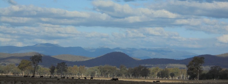
The surrounding tall, forested hills and the gentle folds rolling down to the river present a very picturesque and comforting setting. It feels remote but secure. I get passed by a few cars coming and going out of the valley, but it is generally quiet and the pavement good. One man calls out to me from his front gate, “Ah, you’ve got a good morning for it!” I smile and wave. Does he not notice the thick smoke that hangs in the air like a translucent curtain which slowly reveals the scenery as you proceed toward it?
I come across a very large concrete cairn commemorating the exploration of Hume and Hovell who passed through here in 1824. They were looking for a good route from Sydney to Melbourne. I don’t know why they were up in this area and not further west where the terrain is more gentle. I think about other cairns marking their journey I’ve seen in the past, and I come to the conclusion that they zigged and zagged all over the place. I think for awhile about how you would pick your route and what the land might have looked like to them.


Finally, the road takes a sharp curve and begins to climb. The Spring Creek Road takes off up a steeper hill and we hug the creek which has turned into a series of very rocky cascades. There are bald hills rising up from the road on the left and the smoke gets thicker and thicker. Still, I’m really enjoying the scenery and quiet road today.

Soon enough, the pavement ends and the gravel pitches up. It is in great condition and there are no ROAD CLOSED signs. Just a little ways up where we enter the Toombullup State Forest, there is a sign warning of Smoke Hazard. Um, yes. It is getting thicker as we go.

The road, though, is pure delight. The gravel is in great condition and the grade very manageable. Oh yes, we are definitely going up and the climb is quite continuous, but it is just a beautiful ride through the forest. The road winds in and out of the gullies and there is a quiet peacefulness that just flows into me. The smoke flows in, too, and I’m a wheezy, mucous-producing mess, but even in the smokiest bits, I’m able to keep things under control.


We pass through the burn area – all on the downhill side of the road down in the gullies. It is interesting to see what burnt, what didn’t and what is still smoldering. It shows how differences in aspect and vegetation type influence burn intensity. I also see a few spots where the burn has escaped and there are rough, earthy-smelling bulldozer lines pushed through the forest to contain the break. I note places where they’ve pushed over tall trees from the road that would have been in danger of falling over the road when the fire burnt them out. In a weird sort of way, it adds to the ride. Of course I would prefer it not to be so smoky, but it’s still pretty cool to see a really fresh burn.

The greatest part of this whole section of road is that I see not a soul. For the 1.5 or so hours from the start of the gravel to the Tiger Hill and Old Tolmie Road intersection, I don’t encounter a single vehicle. Bliss!!!
When I finally pop out at the intersection, I see about five utes all gathered there. There are a bunch of men in an opening below the road. They are all standing around a big, fallen log. They are hunters. They look at me like I’m one of Greg’s Yetis or Bunyips – or like I’m some ethereal ghost that just emerged from the smoke. I wave and one tentatively waves back. Then they go back to looking at the log. I’ve got no idea what they’d be looking for in there – pigs (they don’t look like pig hunters and don’t have pig dogs), foxes or something else? Strange. It makes sense that they’d be hunting here near the burn boundary – looking for the feral deer that moved out of the burn area – but deer don’t get driven into logs. I never get an answer, but several of the guys hop in their utes and take off at speed down the Old Tolmie Road.
Then it’s back to peaceful riding through very tall Stringybarks. They are impressive, but they are second or third-growth. When you see some of the old stumps with five-foot diameters, you can only imagine how magnificent it once was.

The Stringybark Creek site is 600 metres up a side road. This is where Ned Kelly and his gang killed three police officers who were after them for previous offences. It was after this incident that the manhunt really stepped up and ultimately ended in the Glenrowan Siege (I’ve shown you some pics of Glenrowan on a couple of previous rides).
They have done a lot of work here in recent years. When I was here in 2007, there was an informal track to the Kelly tree and bush-bashing to the actual shoot-out site. Now there are formal paths and interpretive boards. There are plenty of new picnic tables in a pleasant setting and a formal track over to the campground. I get some food in and mucous out, say hello to a couple who arrive as I’m leaving, and then get back to the climbing.


The road gently continues up through the forest – which looks much more flogged through these parts. It’s been mined and logged and used for who knows what else. There are camping sites next to the Stringybark Creek site and 2-3 kilometres further up the road at the old Toombullup School site (the school site looks quieter, shadier and more pleasant).
Eventually, we leave the forest behind, climb up through pine plantation and then finally get the downhill through private property of open paddocks and orchards carved out of the bush. Then we go flying down below the massive power pylons for the electricity lines running to Melbourne. The road goes crap here and it’s a bit dodgy the last 4 or 5 kms into Tolmie. (You have just entered Wangaratta Shire and it’s our first taste of their current upkeep of their gravel road network).
Once in Tolmie, just to the right is a shelter and public toilets with running water. The pub is just over the road. Tolmie is up at about 800 metres, so it’s often cool, wet and windy up here. I can imagine that shelter would be heaven if coming through here on a crap day. Even today there are grey, scuddy clouds that threaten rain.
After a water refill, I start heading up toward Whitlands. I know this area very well. The rest of the ride to Moyhu today was all part of my case study area for my PhD. I know these roads very well from driving them at all hours of day and evening. I interviewed more than 50 people about their experiences in the 2006/07 bushfires (Tolmie residents had a particularly terrifying experience because the area is surrounded by bush and pine plantation and there are many homes tucked up tiny roads in the forest) and did a mail survey that was census of every household in the study area.
I haven’t been up here since 2009 or so, and it’s really interesting to see how things have and haven’t recovered. I often wonder how certain interviewees have moved forward and whether some of the most traumatised have ever fully recovered. It is also interesting to see all the wattle regrowth and how all the open views of the valleys and burnt pine plantations have disappeared behind the feathery wattle leaves and scrubby gum saplings.

There is a decent amount of traffic on this Sunday afternoon, but most everybody is good about giving me room. There are heaps and heaps of motorbikes out today of all persuasions – the ‘bullet’ bikes, Harleys, touring bikes, cruiser bikes, choppers and enduro-type bikes. In America, the motorcylists often give you the victory wave (two fingers pointed toward the road) or thumbs-ups. But in Oz, it’s usually nothing or sometimes a nod. But today, I actually get a long honk and big nod from a guy on a Chopper no less!

The road climbs up to the plateau. There are plenty of climbs and descents as you undulate along through the plateau. There are also some great drops on squiggly bits where the road hugs the cliff and drops straight off to the valley below. There are a few bits where you’d expect a guardrail that there is nothing. There are a couple spots to get pics, but I’m flying along downhill, so I’m sorry, you miss out. If you ever do ride this road, though, you should do the side-trip out to Powers Lookout. The ride there and back, and the short walk at the site are most definitely worth your time. The views are great… but I’ve been out there so many times, I’m not going out there today. Sorry, you miss out, again.
Eventually the road drops off the plateau through a series of curves and one switchback. There are great views as you fly down through the roadcuts. Most likely, you’ll head on down to Whitfield. But the Whitfield Road is pretty heavily travelled, particularly on a weekend, so I turn off onto the dirt to head toward Myrrhee. I like the Boggy Creek Road better – it lies on the other side of a ridge to the Whitfield side, but it traverses down a narrower valley that just has a more secluded and laid-back feel. The Whitfield side is a wide valley with the King River running through it – the Boggy Creek side is more intimate. But don’t let me put you off the King Valley… if you like wine and Italian varietals… it is definitely your place. It has a stunning setting, too. If you like a sparkling red, then I can also highly recommend Chrismont’s Marzemino Frizzante. Good stuff!
But today, down on the road to Myrrhee, I’m getting really exasperated with Wangaratta Shire Council. The gravel road is beyond terrible. Beyond awful. The corrugations are so deep I think I would have bounced off the bike if I did not have toe clips. I’m certain my boobs bounced off my collarbones at least twice – and that is saying something if you know how tiny my boobs are!! What is not terrible corrugations is all down to exposed road base. This is like riding on uneven cobblestones but without rounded edges. I think this may be the longest 7 kms of my life. That’s an exaggeration, of course, but oh my goodness, that road was shockingly bad. Poor Verne and his head!
The Boggy Creek Road is pretty blissful and I’m just putting down the miles under a big blue sky clotted with lines of clouds. The westerly wind isn’t impeding progress too much, and soon we find ourselves in Moyhu. There’s a pub, a park, a school, a bowling club, a cafe, a crappy general store, a crappy caravan park and a group headquarters for the volunteer fire brigades.

I get some milk and ice cream and ponder the rest of our day. I could stay here at the so-so caravan park, but for some reason, Moyhu smells like sewer today. So let’s keep going – we’re only 62 miles into the day, my legs are okay, my lungs have recovered from the thick smoke, and we’ve still got some daylight. So off we go towards Milawa.

Unfortunately, Wangaratta’s upkeep of the gravel roads on the flats are as bad as the Whitlands-Myrrhee Road. Corrugations, road base, chewed-up sandy shit, thick mounds of stuff even the cars can’t drive on. Oh, this goes on forever, or so it feels. There is also a car every 5-10 minutes and I have to keep getting off to let them use the one navigable path down the ‘road’. Ugh.

I finally make it up to Milawa. Poor Verne, I’ve shaken that poor turtle’s neck and head on so much gravel today, he may never let me choose a route again. Milawa is the centre of a gourmet region – and you can pay $10 for a tiny jar of mustard, or indulge in olives, wines, breads, cheese, gourmet pub meals or visit a distillery. Or not. I’m saving money for bigger and better things. So we sail right through. I don’t particularly like this area on the weekends anyway – there are plenty of cashed-up, pretentious patrons from Melbourne on the weekends, and the vibe is different than if you visit through the week. So we sail right on through.
The light is getting low. These short days are tough to get the miles done in the available daylight. I head for the bush reserve at Tarrawingee and only find one caravan down by the river. There’s a nice, soft grassy site a fair distance away from them and I plop my stuff down there. I get cleaned up (covered in dust!) down at the river while the guys enjoy the greenery and water. Then it’s up with the tent, consumption of food and an early night after the early sunset. It’s been a long day with a lot of climbing – but I loved that Tatong-Tolmie Road. It’s been on my ride list for so long and now I can say I’ve done it!

