

Heading out to Toadstool Geologic Park: Fort Robinson State Park to Toadstool return
Monday May 13, 2013, 46 miles (73 km) – Total so far: 1,200 miles (1,931 km)
Toadstool Geologic Park lies about 19 miles northwest of Crawford within the Ogalala National Grassland. It features stark, rugged badlands topgraphy rising up from the grasslands against a backdrop of the Arikaree buttes. It’s not really a place you stumble upon. It’s a place you have to decide you want to go see.
My original plan was to camp here for the night and then continue north to meet back up with Hwy 2 on the way to Hot Springs, South Dakota. However, there is little shade at this site and no water. Heading north, there is no reliable water source until quite close to Hot Springs.
So a few things sway my decision to just make this a day ride instead: a forecast for record heat in the 90s; no knowledge of road conditions for the 15 miles of dirt one-way; a fear that I may have a medical problem that could get worse and require medical attention; and the thought of how much water I’d need to carry. So, day-ride it is.
It’s about 8 miles from Ft Robinson to the dirt road turn-off. Immediately, the road climbs a small hill on well-graded dirt covered with loose gravel. It’s hard to find a good line anywhere but near the centre, so when a car or two goes by, I just have to stop, walk/push the bike to the edge and wait for the cars to pass before I resume. Unfortunately, this is the best surface I find. They obviously haven’t done much work on this road yet this year – if you can think of a crappy road surface, it was represented here.
It’s a long slog requiring lots of concentration. There is nothing to entertain the eye really, anyway, so I just keep my eye on finding the best line. There is just grass, an occasional clay-bottomed puddle big enough for birds and a dry creek here and there eroding away the surface of the grassland.
Gentle hills escort me further into isolation. There are a few ranches along the way, plus the BNSF rail-line paralleling the road, but mostly, it’s 15 miles of a whole lot of nothing much.

Finally, we reach the turn-off to the park. I get off and carry the bike over the big ballast pieces and the holes edging the railway. Then it’s more careful riding to find the best line on the two-track road to the parking lot. The layers of clay and ash are readily apparent in the hills; the subtle bands of colour almost look like they’ve been painted on.
These rocks, and this banding, are formed from sediments from the White River Group. The rocks here form the type section for this Group. This means it is the standard for all other similarly-aged deposits on the continent. This also means geologists come from all over the world to see and study this type section. Cool stuff!

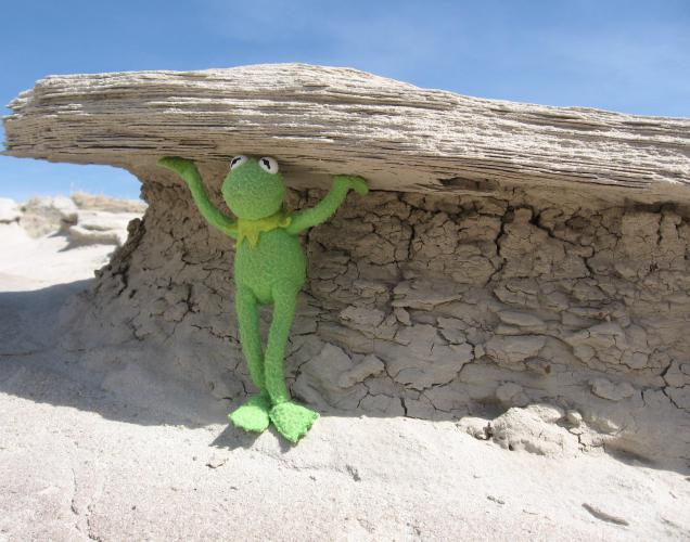
The White River Group is made up of three formations (Brule, Chadron, Chamberlain Pass) deposited during the late Eocene to the Oligocene (24-38 million years ago). The formations consist of gravel and sand from ancient river channels, and fine silts and clays that are easily eroded. The ‘toadstools’ are formed where rounded blocks of more resistant sands and gravel lie over the pedestals of clay, like Kermit is holding in the picture below. Some of the fine silt is volcanic ash blown here from the west. The glass shards in the ash make up more than 50% of the material in these sediments.
The clays, derived from the weathering of the volcanic ash, shrink and swell with wet-dry cycles. This produces a ‘cracked and clotted’ surface informally known as ‘popcorn’. You can see it in the photos below, too.

Paleontologists also love this park. Fossils are very abundant here. New fossils are frequently exposed, as the badlands erode at an average of an inch per year. The most abundant fossils are land tortoise shells one to two feet long. Other fossils found here include: oreodonts (even-toed mammals), deer, giant pigs, an early camel, three-toed horses, relatives of tapirs and rhinos, rodents, small dogs and saber-toothed cats.
What makes riding that nasty dirt-road in record heat worth it for me, though, is seeing the rhino trackway. I am so impressed. It stretches for nearly 3/4 of a mile, the longest and most diverse known trackway in North America for this period. Standing there in the hot sun and dry, still air, it is hard for me to imagine this any different. 30 million years. C’mon, Nerd Em, just imagine yourself standing here 30 million years ago in the sloppy mud as these distant relatives of today’s rhinos and pigs break into a run from a slow walk. Wow, wow, wow – this is so fantastic!!


The nature trail also takes you by a large fault that shook the earth 2-8 million years ago. If you like this sort of thing, you can search out both northeast and northwest trending faults in this park. It’s hard to see exposed fault lines in Nebraska – so this is a treat, too.
As much as we’d like to spend more time here exploring the creek beds and beyond, the heat and lack of shade mean we can’t stay as long as we’d like. Since we haven’t even seen a temperature in the 70s F before today on this trip, the 90s feel really hot. It’s not unbearable, but I’m mindful I still have 15 miles of dirt to ride and then 8 more miles of pavement after that to get back to our campsite. So after a couple of hours of enjoyment, we start our ride home.

I stop at the Dairy Freeze type place on the way back to Fort Robinson and order some chicken strips and a flurry/blizzard type dairy dessert. I think we deserve it today for doing that ride in what turns out to be record 94 degree heat. Once home, we spend the afternoon lazing about in Soldier Creek. I’d been really looking forward to this day, and it did not disappoint!

