

4 March 2018
Kilometres: 74.13 kms (46 miles)
Total Kilometres 2018: 1193 kms (741 miles)
Day 3
I slept well last night. Even though I’m exhausted a lot, I don’t always sleep well at night. Why, body, are you betraying me? I give you lots of veggies and healthy stuff, I rarely drink alcohol, I don’t eat much red meat, and I give you some junk food on occasion. Stop being mean!
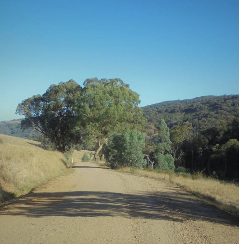
There are kangaroos and wallabies all over the place this morning. I hear them thumping off through the understory or spot them racing along the road or doing a last minute dart up or downhill. The forest is still beautiful and I still really like this road. It is a rollercoaster up and down the top of the ridge and plateau, but the forest looks healthy and there are really great views through the trees. The surface remains excellent. I will definitely come back to do this again as a day-ride loop from Old Tallangatta sometime when it is cooler!
Up and down, and back and forth through the gears. No one is camped in the picnic area. No one is on the road. It’s just me, the turtle, the frog, and some marsupials. You can’t get a better morning than that.


We eventually fly out of the park onto a paved section. It flings us down to Jarvis Creek through open farmland. The plateau is now off and above to our right. We run right down to the creek where we run out of pavement and descent. Now we must climb up to the end of a plateau spur again through rounded hills with excellent views. Sirls Road is a winner through here.

I pass a farmhouse. A little bit further along, as I’m crawling on up the gravel, a ute from the house passes and stops just ahead. The woman lets her dogs out into a paddock and they go screaming down for a swim in the farm dam. I chat with the woman who says she sees cyclists on occasion these days, more than they used to, but she thinks this road still remains a bit hidden. (I can tell you it is not because it is hidden but because its surface would be unrideable on a road bike for much of its length).


I finish up the hill and then we get about 9 kms of downhill on very rough gravel. It is a combination of bad things, but there isn’t much smoothness anywhere. I have to keep pushing Kermit back down in the handlebar bag as he keeps vibrating and bouncing up.
But it is beautiful – the road weaves along with the forested plateau off to the right, the creek immediately below and the cleared hills all around. It’s like riding through a succession of clefts in a bunched-up blanket left on a bed. If this road were paved, it would be pretty heavenly. Instead, we rattle away and pick lines through the erosion and have a couple of oh shit moments that don’t amount to anything.

At the end of this road, we have two moderately steep ramps and one gentle section of road to get us up over the next ridge. I’m slowing down already – that’s not good! But up we go, with only a couple pesky flies. This part is paved, and we pass many smaller blocks with nice homes with spectacular views.
We crest the ridge and look down on Bethanga. I’ve been there once in a car. It was built in a mining boom, but now it’s just lifestylers escaping Albury-Wodonga. They have lots of trouble with water and mobile phone reception out here. My only concern, though, is that strip of black on the opposite side of the valley that goes straight up. We have to pedal that soon. And we have to drop all the way down to the valley before we can commence the climb.


Down we go. The little town has a pub and a general store, but everything is closed. I slowly grunt my way up to Kurrajong Gap. I did not need that steepness after yesterday’s climbing and this morning’s efforts already. It’s steep enough, and enough effort on this level of fitness, that I feel like I might puke.
I don’t. I get a picture of the dam, see four roadies, then head down the hill standing on the pedals. I coast it right on down, get passed by two roadies and then hit the edge of the lake and Bellbridge. Pee stop, and most importantly, water refill stop. I was down to the final sips.

Then we head over the long bridge back to NSW. The roadworks are finally complete, and this section of road now has a shoulder and wider lanes. It used to be quite unsafe to ride – it’s all good now.
I head down to the dam wall, find a picnic bench in the shade and tentatively take some food in. It sucks not being able to eat very much, because my energy needs are greater than what I can put in during a ride. Stack that on top of the fatigue… and let’s just say, my performance is suffering.


I hang there in the shade for awhile. I am really done right here. I could so easily just not go any further. This is enough for me today. BUT… the car is still 25 kms away. So after sunscreen application, we are on our way over the dam wall, down the Bonegilla Road and up to the intersection with the rail trail.

Here I finalize the questionable decision. The rail trail is the quickest way back to the car. There will be no more hills. But the surface through that section is crappy, and I’ve done it several times before. No. Mahers Road continues on the back side of the ridge into the Kiewa River valley. It’s paved. We’ve not ridden it before. We’ll just have to climb back over the ridge later on and then hook up with the rail trail where the surface comes good.
Yes, I’m already flogged. But I cannot pass up a new road. The sense of adventure is a fiercer flame than the fatigue. So we continue on the road. It’s tree-lined to start. The rollers start immediately, too. Crest after crest, I begin to wonder just how masochistic I can be. However, the views are excellent and the flies non-existent. I can tell you a positive for almost any situation.


There is little traffic, the chipseal is decent and it really is a beautiful, though slightly hot, day. It’s all very good. I am very happy underneath the veil of ugh. We finally get to Coulston’s Road. This is a gravel road that cuts off about 5 kms and a loss of elevation down to Tangambalanga… and the subsequent climb back out.

Coulston’s Road gently climbs. I may never have gone so slowly on such a gentle gravel grade. Pedal. C’mon, Em. Just pedal. We get ourselves there, but I dare say it isn’t very pretty. The final climb back over the ridge is on pavement, and I somehow find a little groove and make it to the top without difficulty.

We are back in the Mitta River catchment – who knows how many drainages we’ve climbed in and out of on this trip, but we have been in three major river catchments (the Murray, the Mitta Mitta and the Kiewa).
Looking back, I can tell you this was way too ambitious for our health and level of fitness. This would have been a pretty difficult ride for elevation gain, even when we were 100%. It is so easy to get carried away when you are looking at the map! If it had been cooler, that would have helped, too.
Soon enough, though, we are down to the lake, and I give the guys a long floatie session while I just lie there and get the oomph back to ride the last 12 kms back to the car. I’m really done!

I’ve ridden this rail trail many times. Of all the ones in Northeast Victoria, I like this one the best. I see about seven people out today – there would have been more in the morning when it was cooler. One guy stops me and asks the normal questions – he isn’t disappointed when I say I’m just doing a weekend ride. He thinks that is the most awesome way to spend your weekends and wonders how I know where to go and what to take. I tell him “what to take” is easy because I’ve been riding for a long time and know exactly what I personally need and don’t need. And then I tell him, “where to go” is easy, too – look at a map, stay off the C-roads, and just pick a road. The next weekend – pick another new road. The possibilities are endless. He laughs and says, “I don’t think I have that in me. I get nervous if I’m not on the trail.” I tell him he could build up to it – just a little more adventure each time until one day he can’t remember ever being hesitant at all.


We finish up the ride. I load up the car, I wash up under a tap, I change clothes and then head into town to hang out by the river in the shade for awhile. I’m staying at Nigel’s place tonight ahead of a doctor’s appointment tomorrow, but he’s a pretty sad sight these days, so I want to minimize my time at his house.

I am very proud of what I accomplished on this ride. But I am also very aware that I am still very far away from where I want to be in terms of strength, fitness and endurance. But I will persevere. The frog and turtle won’t let me stay home long, and the call of the road is not a gentle whisper on the wind but a screaming tempest carrying me forward.