

4 June 2018
Total Kilometres: 42 kms (26 miles)
Total Kilometres 2018: 2315 kms (1439 miles)
I am glad I am not a farmer. Oh yes, the idea of making your living off the land, and cultivating a crop and a relationship with the earth… oh, that all sounds attractive. But to be a farmer, you’ve got to be a gambler. You’ve got to try to read the weather, the commodity prices and the future and then make decisions about when and what to plant. And then cross your fingers that a big round of hail doesn’t wipe out the whole thing. Then, in autumns and winters like this one, you’ve got to just wait and wait and wait… for rain that doesn’t come.
It is another beautiful weekend. We did a short ride on Saturday, trying to save some energy for the more difficult ride we are doing today. I posted a few words and pictures about that gentle pedal here.
I had thought I would do today’s ride on Sunday, but Sunday dawned cold and cloudy, and my body said we weren’t doing anything that day. Once every three weeks or so, I spend nearly the entire day sleeping. It’s not particularly refreshing sleep, but my body just says we aren’t doing anything else. Then I’m back to just the normal exhaustion and unrefreshing sleep. So that was Sunday.
Today we head down to Whitfield. What I would really like to do is a loop of Mt Emu, but I can tell that ride would just be too much today. I am hoping I will have improved enough to do it in spring. So, instead, we’re going to do a short figure-eight route that will give me some steep climbing over a short distance (about 350 metres over six kilometres) just to see how my body responds to that. The rest will be pretty gentle riding up the main river valley and a couple tributaries.
I park the car on the side of the road near the Gentle Annie Caravan Park outside of Whitfield. I know this whole area intimately as it was the study area for my PhD. However, I haven’t been down here in about six years, so it will be interesting to see changes.
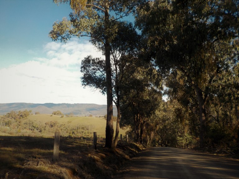
We head along the Edi-Cheshunt Road along the valley wall. The King River flows in a sinuous course down the valley – its path easy to pick as it is the line of trees running through crops and dairy paddocks. The King River rises in the mountains about 20 kilometres south and flows into the Ovens River just outside of Wangaratta. There is a dam upstream that controls flow levels. Major flooding in 2010 altered the river’s course through the valley – some farmers had significant chunks of paddock removed and shifted downstream overnight.
I turn off from the main valley and start into a gentle climb among large, rounded, cleared hills that lump at the feet of the main spurs of the Black Range. Forest closes in and we get the first steep climb. I don’t know the percent grade, but it is easily over 12. I grunt and spin up this – heart pounding and my legs insisting that we don’t really have the muscle left to do this. But I make it up.

There’s a short descent to a saddle where the high-tension power lines cross and march toward Melbourne. Then we commence two more steep climbs through forest, riding over the long spurs that branch out from the main range.


But all that up means there will be some down. We fly along through the twists and wind our way down to the valley of Black Range Creek. Just as we come out of the forest, the property of King Valley Fine Foods drops in a well-manicured series of steps down to the valley floor. Ahead of us, the length of the valley rolls away and up to the narrow dip between ridges named Cropper Gap. Way in the distance, above the gap, The Horn on Mt Buffalo pokes its head up as a staunch granite peak. It’s a gorgeous scene made even better by the fact that it is so clear and crisp and it’s the 4th day of winter!


I ride on up the creek valley. The range is fairly close on both sides, and all accounts are that it was pretty scary up this way in December 2006 as the fires spread quickly on the range to the south. Long-tenure residents reported large gaseous fire balls leaping across the valley. Some parts of the valley floor burnt and some stock and fences were lost. One unoccupied shack was lost, but the 7-10 homes were saved. Some of the trees along the creek still bear black trunks and some parts of the ridgetop are still scarred and fuzzy-looking more than a decade later.


I climb gently toward the end of the valley. I’d really like to be continuing over the gap, then climbing Bread and Butter Gap and then returning via Upper Carboor (where we rode a couple weeks ago) and Edi Upper. But that is too much for today, and I’m trying very hard to stay within my ‘energy envelope’ so that I do not suffer from any post-exertional malaise or zombie crash. I am hoping I can continue to very slowly get better and better if I don’t keep causing small or medium relapses.
So when I get near the head of the valley, where the road turns 4WD and dry weather only, I turn back and enjoy the cruise downhill. I have a great story about driving that road during my PhD – not in a 4WD and not in dry weather – but it will have to wait until I ride that section next spring.


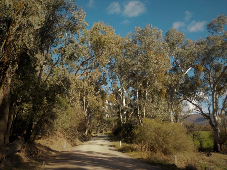
Once I get back to the road junction, I turn right and head down the rest of the Black Range Creek. There are tall hills in all directions, and it is a joy to just be out here in such beautiful weather, rolling along the road. Because I bagged out Rural City of Wangaratta and its roads a couple weeks ago, I must renege on that and say that all of the roads I ride today are in good to excellent condition. They are almost all small gravel over hard-packed clay. Because it’s dry, it all rides very well today.


We turn off from the creek and head over a small hill near Edi Upper Primary School. It is amazing that they let these tiny schools remain. There would be 12 pupils or less, but there it sits on the side of the hill – a few demountable buildings, an impressive playground and four tire swings hanging from large trees behind. Today also appears to be ‘cycle safety’ day. There is an adult all geared up with safety equipment on a BMX bike to show some tricks, and the kiddos are practicing on a traffic safety course set up on the tennis court. There are GIVE WAY, STOP signs, etc. Sorry no photo of this or the school, but I feel strange about taking photos when kiddos are present.

We get a short section of chipseal as we roll down the hill back to the main valley. We then ride the gravel Edi-Cheshunt road all the way up to Cheshunt. In places the road hugs the valley wall and climbs to a bench above. Where the valley opens up in other places, we twist along on the valley floor. There are views over to the ridge on the opposite side of the valley which burnt earlier this year. Singed canopy and a few ghost trees remain as evidence. The other side of the ridge on the Boggy Creek side burnt more severely.
We can also look up to the Whitlands Plateau which leads to Tolmie and then down to Mansfield if you ride far enough. There’s a 600 metre climb to get to the top of that one. I’ve done the climb from Tatong to Tolmie and on across. I’ll do the climb from this side someday. Today our body is more in tune with valley riding.


The general store at Cheshunt is open but still for sale. It also serves as the post office and paper delivery point– many people further up the valley and toward Rose River do not have mail delivery. The store here has always been in competition with the general store in Whitfield just six kilometres away. There is a social divide in that six kilometres between immigrants from Northern Italy and immigrants from Southern Italy. Cheshunt South has the southern Italians; Whitfield the northern Italians.

There used to be a little café at Cheshunt, too, but it looks like that place has been converted back to a house or maybe Air BnB type accommodation. There’s a CFA shed and a Memorial Hall (of course), but that’s it for Cheshunt.
I stop for a few moments to eat a banana. All day today, I’ve been thinking about the people I interviewed for my bushfire research in my PhD. The stories and raw emotions my interviewees shared were very personal and, in some cases, very traumatic. I was so humbled that they would share such deeply personal experiences with me as a stranger. They had very good intentions – they all hoped by sharing their stories that they might be able to prevent others from going through what they did before, during and after the fires.
So I’m thinking about those people, a few in particular that I worried about their mental health at the time (we always shared health resource contacts and encouraged people to use them as part of the research fact sheets we handed out). I wonder what happened to them. I think about some of their kids who would be teenagers or older now. I send them all well wishes in my head, and I sincerely hope they made full recoveries in the past 11 years.
I cross over the river and past a man burning big piles of downed tree limbs along the road. The heat coming off the fires is nice; the smoke in my lungs not so much. A truly generous person would have chainsawed up all those pieces and given them to elderly people in the valley reliant on woodheaters. Or at least that’s what I would have done if I weren’t leaving it on the ground for habitat.
We round the corner and head back north toward Whitfield. We pass by the extensive vineyards of the Pizzini family. The vines grow in lines straight up the fairly steep hill. The Pizzini family are sort of THE family in the valley. Their winery, in repurposed tobacco sheds, is one of the largest and well-known in the area. See their offerings here. Their children own the Whitfield pub – another family member owns Chrismont (which produces a stunning Marzemino Frizzante that I would ride up and buy if I had thought to bring cash with me today!). They have cooking schools with the ‘nonnas’ who will teach you how to make sausages and gnocchi, etc.
It is all quiet today, but there will be plenty of activities going on this coming long weekend (Queen’s birthday). There is a balloon festival and, even though the ‘Weekend Fit for a King’ isn’t going on, there will be lots of special events taking place at each of the wineries.
I stop for a toilet break in Whitfield. Whitfield is just a tiny little place where the road takes off for the Whitlands Plateau. There’s a pub, a school, a preschool, a petrol station, a police station, a National Parks office (not for visitors), a café, a general store and a caravan park. It all takes up about a block. I don’t see a good way to get a picture that would really show its character – probably because there isn’t much character to it. It’s all just a block of functional buildings and a few homes.
I am happy to see that they rebuilt the general store after it burnt down in 2013 (story here). The new structure is just a big tin shed, basically, with a bunch of outdoor seating. I pay my respects in my head to the woman who died in the fire – I had contact with her husband in my research as he was the CFA Captain for Whitfield at the time.
We then ride the few kilometres back to the car. At the time I did my research, there was just a single-lane wooden bridge over the river at the caravan park. The last time I was up this way the old bridge was still next to the concrete, two-lane new one. It’s gone now. The river has really shifted and moved a lot of rocks in the flooding, too, so it really doesn’t look very much like the place I camped for weeks at a time back in 2007-2010. Of course, I’m not the same person either. Things have shifted; bits of my heart have chunked off in various floods; and debris has built up in other places. Other parts of my life have moved with the flow. Nothing is static. Nothing stays the same. This is what gives me hope that I’m eventually going to be healthy again, too. In the meantime, I’ll keep enjoying this amazing weather. As long as it lasts and before it changes, too.
Hi Emily!
Three thoughts: 1, what great weather for a ride; those blue skies and puffy clouds scream good time. 2, “large gaseous fireballs leaping across the valley;” holy cow, that was fierce. Reminds me of Norman Maclean’s book “Young men on fire.” One member of the firefighting crew survived by laying down in the ashes of a backfire while a forest fire swept over him. He said the inferno nearly lifted him off the ground at moments. 3, I don’t make it up 12 percent grades, so hats off to you.
Thanks, Chuck. I do not do anything over 10 percent grade very gracefully, even when I’m tour fit! But I was happy enough with it – and quite surprised I could make it up, actually. The official word is that fires do not produce fire balls – but enough reports from the 2003, 2006/07 and 2009 fires from credible people have made fire authorities reconsider. I should get in a ride tomorrow and something Monday before we finally get a turn to a rainy week. We need that rain desperately, and I don’t mind it too much when I’m inside at work!
People who experienced the 1967 fires in Tassie talk of fire balls too. Another good ride Emily – excellent weather for cycling. I wonder if the dry weather will hold until we get to cycle in Victoria starting in 3 weeks. It’s certainly looking hopeful.
The Whitty Cafe. I remember how good it was to roll down that hill and find the cafe at the bottom. I grabbed a coffee and cake and went to sit outside as I reckoned I was probably a bit on the nose after climbing up from Mansfield. I then took my cup and plate back inside – and was told this is just not done there!! Didn’t I see the sign?? Leave crockery on the table. Oh. OK.
Oh yes, there’s been talk of fireballs all along – but the fire authorities have always liked to discount them… until they started being the ones reporting them!
We may finally get our ‘autumn break’ this week. It is only about 8 weeks late. They are predicting rain every day between Tues and Sat – some of the falls up to 20mm. We won’t get that much, but it is the first round of rain since last spring. Even in a dry year, we still get rain in winter… just not as much. This year feels a lot like 2006 did, and that year I was bushwalking up at Dinner Plain with no snow in August. It felt silly to have snow chains in the car for Mt Buffalo that year! I hope you get mostly sun for your VIC trip coming soon 🙂
Yes, The Whitty Cafe is a good one. They started up in 2011, I think. It wasn’t there during my PhD, which was a good thing as I didn’t have the budget for cafe meals then! I didn’t stop this time as I had plenty of snacks with me. It would definitely be a welcome sight after a ride from Mansfield!! Well done 🙂