

5/6 October 2019
66 kilometres
The season is upon us again.
No, not spring. I am not sure Australia really does spring. I really think winter just becomes pre-summer here.
No, the season upon us is the shiny season – when the application of sunscreen and at least a bit of sweat makes your face, arms and legs gleam in the sunshine.
And so, this is my first ‘long’ ride with sunscreen applied since last April. I use sunscreen on my face all year, but don’t bother with my arms and legs in winter. I usually ride in shorts year-round – winter sometimes sees a jacket, sometimes not.
My body suggests that it has already had enough for the week. I know this because I have the weird tingling cramp feeling in my legs and I feel pretty blah. Since the relapse in June, I’ve had to sleep most of Saturday each week to catch up some energy after the work week. That leg pain is a sign that I am already in energy deficit. It doesn’t matter if I have had a big week mentally or physically, all energy over-expenditure shows up in my calves.
Yet, this is the first weekend where the weather, overnight temps and the things I need to do will allow a ride. So legs, be damned, we are going for a ride! I will deal with the PEM when it comes.
Through the week, I plot out two routes. They will each be about 30 kms in one direction. Which ride we do will depend on what the forecast wind directions turn out to be.
Saturday suggests we will be riding up into the Barambogies via Byawatha. Winds Saturday are predicted to be light. Winds Sunday are not predicted to be light; but they should blow us home.
There are some isolated showers about which weren’t in the forecast, but I don’t think there is much in them. Still, I hang out until around 1pm before I head out. Since I can’t ride very far at the moment without causing an exacerbation of symptoms, I really only need a few hours allotted.
It is nice to load up the bike. Even if we will only ride a few new roads, I always love having all my gear with me and the sense that I could keep going if I wanted. Today I take my light sleeping bag, sleep sheet, off-bike tshirt and wool base layer top, off-bike pants, a packet of curried salmon and a sandwich bag of nut mix. I pack in three litres of water, a map, camera, ipod, headtorch, tools, toiletries, tent and sleeping pad. It would all fit in the rear panniers, but I really like the weight distribution when flying down loose gravel with all four panniers. It keeps the front wheel anchored a bit better.
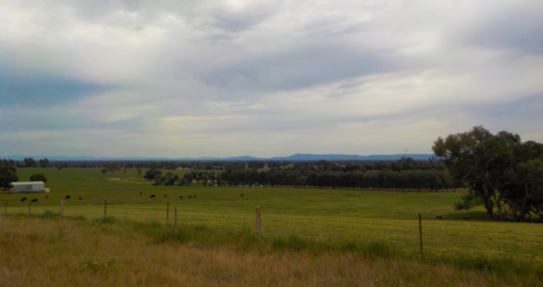
So off we go. There is a bit more wind from the west than I’m expecting, but I just take it slow and pedal away across all the flat land. We are heading up toward Eldorado and the hills behind, but we will turn off before that village and head via the Byawatha locality instead.


I test the theory that only 10 percent of magpies swoop. I count the magpies that cry out at me or fly to a tree above me but don’t swoop. My rate over 31 kilometres today (all in the first 25) is four non-swoopers and 2 swoopers. That’s more than 10 percent, but the sample size is unreliable. More research will need to be conducted. I usually get swooped until the beginning of November, so we’ve got more data collection time.
Once we drop down and then climb back out of Reedy Creek which runs through the Woolshed Valley and on down through Eldorado, I turn off on the Clear Creek Road. This one is sealed to start and parallels the creek. There are farmhouses scattered about, but not many people out.


The clouds darken and there is virga wisping down from some in the distance. I am actually happy for this cloud that was not in the forecast – it is keeping the temps and sun exposure down.
From Clear Creek Road we turn up Grealy Road. The land undulates here – all the outskirts of hills that form the Barambogie Range. We slowly climb – my muscles remind me that we haven’t ridden a lightly loaded bike in a while! That tingly stuff in my legs is noticeable but does not seem to be getting worse.

I get up to an intersection. I could continue up Grealy Road to catch the Byawatha Road. It looks steep up ahead, so I gamble that Allen’s Road might be better. I don’t have a topo map for this area, so I can’t make an educated guess. It’s all hilly, so it’s just a matter of which is steeper. I can see that at least the easterly run on this one won’t be steep.

So let’s go. The clouds release their weight, but there is not much in them. There are a couple splats here and there, but nothing as bad as could have been given the darkness of their appearance. The drops momentarily scatter the flies, because yes, fly season has apparently started, too. I’ve been escorting at least 9 on my shoulder for most of the ride with another 3 or 4 around my face.
Now you should play this song for Allens Road up to Nankervis Road – it was playing on my ipod as we rode this section. Click here.
Oooh. Allen’s Road goes up, too, but not before it goes down. This time of year when everything is green, it is all very scenic. The gravel isn’t so great, but we fling ourselves to the bottom of the valley. The house at the bottom has a heap of free range chickens… EVERYWHERE, including one on the other side of the road that goes scampering, fluttering and half-flying back to the flock right in front of me. Sorry, lady!


At the top of the climb is another house with a man out shoveling dirt. I can see his brow furrow as he looks at me and half waves. Where the heck did that cyclist come from and why are they here?
At the top of the climb, I can see that had I taken the Grealy Road further, I would have had to climb, descend and then climb again to this point, so I think I come out ahead. My legs don’t agree and my arms are also saying we haven’t held onto a loaded bike in a while, BUT I don’t feel terrible. So on we go. Sometimes I feel terrible just sitting upright!

I can hear a vehicle coming, so I wait and let them go by. Then I fling myself down the hill, too. I try to keep the speed down a little bit as there is a loose layer of fairly big rock on top and I am just aiming the bike the best I can. 40kph was plenty fast for that surface! I keep thinking, “what if a magpie comes?” I’m using all my concentration on the road surface – I’ve got no defense and can’t afford to wiggle or weave if anything comes.
Nothing comes.
Instead, the Maggie is waiting for me at the bottom of the hill where we meet up with Clear Creek and a few houses tucked in along the creek corridor. The magpie calls out, launches… and then flies back to his tree once I start waving my arm.
I head up Nankervis Road. I rode this one the other way back in 2015. When I read back on that entry, I think, “wow, have I lost so much energy and so much fitness!” But check out that entry for some photos going the other way from our ride today. Please note the road surface is not so good now!

I have to pull over and let some cars pass – that same Ford Ranger I let go by at the top of the hill a bit ago, too!

Then I proceed the long climb up that beautiful little valley. It’s pasture down low with trees on the rocky, granite ridges. There are sheep grazing that lush green grass. The road travels ever upward, but it is never really steep. I highly recommend this one – going up or downhill. If I can make it up it in my current condition, then it is do-able for anyone.

While I did not see any cars the day I rode it back in 2015, I have to get off the road for five vehicles this time. They all come from behind, so maybe there was an event somewhere that they have all left. They all overtake me within 30 minutes of each other.

We follow the creek up and up. Sometimes we ride down along the creek itself amongst tall and shady trees. Other times we are up on the hillside a bit looking down on the pasture. The big granite boulders pop out here and there in clusters as erosion continues its never-ending tug at the soil.

I am really enjoying this ride and it doesn’t seem too far above my current ability. I shouldn’t be out here at all, but the climb is a gentle one and I think this has been a good choice. I don’t want this to end, but I do want it to end because I am starting to get pretty tired.


Soon enough we make it up into the state forest. I am ticking South Triangle Road off my list today. We head on up a ways, noting the prescribed burn done all along the private property side of the road last autumn. In some ways I wonder why the public should have to fund those burns, when it is protecting a handful of people’s properties that have chosen to live in a very fire-prone area? I’m sure there is bigger taxpayer fund wastage out there, so I don’t dwell on it.

I do need to find a temporary place to dwell soon, though. There are plenty of places you could plop down not far off the road, but I prefer to get off into the forest if I can.

There is a small two-track that takes off and I follow this uphill for 100 metres or so. I drop the bike and go scout. There are some spots just off this two-track, but the regrowth and other veg is pretty thick. Surely, I can find something nicer.

A few minutes later I found a couple of bald areas where the granite sits just below the surface or outcrops in big slabs. This will be good. I will be out-of-sight of the main road as well as that tiny two-track. Plus, I can set up camp out in the open. It is supposed to be windy tonight, so not being under any limbs sounds like a good idea.
I carry the bike the 150 metres through the bush. I set it down to rest a couple times. It is not heavy, but I am not used to hefting any weight. Plus my arms are tired from holding onto the bike on all the gravel. Plus I’m feeling a bit nauseous. I don’t think it is overexertion because I’ve been climbing slowly and trying to take it easy. I think it must be the heat. It is 26 today and I am not acclimated to it yet. My body has all sorts of trouble maintaining its temperature now, and the heat really knocked me around last summer with all this neurological dysfunction.
Once I get the bike to the clearing, I strip off my shirt and let some evaporative cooling do its work. I pour 200 mls of water on my head, sit down and feel better pretty quickly.

Then it is tent set-up time and time to get my legs up. They swell a fair bit to go with the tingling and cramping, so I am always trying to get them up in the evenings.

I eat while laying horizontal with feet propped on panniers. I watch the clouds come and go above. Some are more threatening than others. I lay there and think about absolutely nothing.

I lay there and then think about how lucky I am to be out here – not one of the 75 percent of ME/CFS people who are house-bound. I listen to the flies and the birds. I then get up and have a look around and let the guys clamber among the boulders. I investigate the wildflowers.


Then I lay back down and watch the darkness descend. I’ve overdone it today, but I don’t feel all that bad. I listen to the mozzies (DAMN MOZZIES) looking for a way into the tent.
I get up and put the tent fly on as there is a chance of rain tonight. More importantly, the wind is supposed to pick right up and there is nothing more annoying than wisps of hair tickling your face in your sleep.
The wind does pick up later. The trees bend forward and backward. They rub against each other like 20 people opening and closing squeaky doors in the distance.
I have overdone it. I know this because I fall asleep for three hours and then wake up. And then can’t go back to sleep. Tired but wired. It is always a sign of having done too much. At least, after almost two years of this shit, I can identify symptoms and understand some of their causes. I am sure I ‘see’ daylight savings come in at 2am. I then doze to the sound of hundreds of trees and thousands of leaves swaying until 6.30am, but then I decide to just go ahead and get on with the day.
The clouds are threatening as they swirl about. It is cool but not cold. The northeast wind is right in my face as we climb up South Triangle Road. There are more granite outcrops and large boulders. There is more thick forest, but most of it is quite open. There are little tracks leading into the bush all over the place.


My tingly cramping isn’t too bad – not much worse than yesterday. This is a nice climb. Eventually we gain the ridge, turn left and zoom around the hill to meet up with Souters Road. I almost don’t make the corner and find myself in some rough stuff quite close to a fence, but all those years on the bike mean my instincts save me and I stay upright and moving forward.

We travel through private property in the upper reaches of the Clear Creek catchment. It is pastoral and beautiful in its own way. The cleared trees let you see the lay of the land and all the outcropping granite better.

We connect up with Old Coach Road. We’ve ridden this way before. I had ideas that if I felt okay I would take off on Ramsays Track and connect it with Lonnies Gap Road down into Eldorado. But I consider three things: 1) the wind is going to swing SW at some point, and I want to be home before that headwind happens; 2) I’m pretty sure my body is already done and that might be just too much; 3) I can’t afford too much PEM and need to get some energy together for the week ahead as I have an assignment due Monday, I’ve been co-opted into catering a morning tea for 50 people Wednesday, and the job advertisement comes out this week for the position I want, so I will need to put together that application. It would be better not to feel like total shit going into all of that.

So we just head on down Old Coach Road. It is a pleasant mix of gentle climbs and falls. We’re among the big boulders and the land sloping away to the Clear Creek drainage. It is good to be out here. It is good to be on the bike.

There is a hard left and then you start the long and sustained drop off the ridge. I keep my speed down for the most part but let it go when I can see the road ahead. At one point, I do hear vehicles coming from behind and find a spot to pull off and let them all go by at inconsiderate speeds raising inconsiderate amounts of dust. It looks like they were all up camping somewhere together based on the number of swags and BBQ equipment I see in the back of two of the utes. Really, who takes an entire multi-burner BBQ with hood camping?!

I fling on out onto the flats and turn toward Reedy Creek again.

Instead of riding up to the sealed road, I decide I’ve got enough time and energy to ride Powerhouse Road. I’ve not got a lot of power, but I ALWAYS want to ride a new road.

This one is pretty flat with sheep grazing lush paddocks on one side and the floodplain of Reedy Creek down below the little bluff on the other side. Back in the day, that whole creek was dredged for gold with a monstrous machine that ran day and night and created such a racket the whole valley could hear it. Today is considerably more peaceful!

From this road, we retrace our steps home. The wind is helping, though it is not nearly as strong as it was last night. Still, we’ll take any help we can. I do get passed by a mini-van near home that says “Bus-a-bike” on it. It has a trailer full of suitcases.
I may be unwell and not be able to go far, but I am not ready to concede to guided tours or ebikes just yet!
I just love the feeling of being totally self-sufficient and knowing that it is ME who got me where I want to go. I may change my mind later, but right now, I’m ready to ride with my limitations and see if I can just keep pushing those out a little bit further and further over time.
Home. This place is 20 times better than where I used to live. The front garden is putting on a great show at the moment. It is such a pleasure to sit on the verandah and rehydrate with a floral show at my feet. Now, to rest up for the big week ahead!


Great ride Emily. The guys look like they liked being out and about too. 4WD camping seems to have really taken off down here too – does nobody walk any more?
Hi Tony- the guys are always pestering me to ride, so they did have a good time! I think the 4WD camping has always been popular up here, but we’ve noticed more of them and more people with fancy boats in recent years. All we can figure is that the builders and tradies have made a bit of money in the building boom and are spending it on toys. We can’t think of any other industry where anyone is making enough money to do anything but cover the mortgage at the moment!
Thanks for another interesting blog Emily. I love the dirt roads in the Byawatha Hills area. Campbell Road, which runs into Nankervis Road is one of my top fave tracks – there are fantastic views when you head downhill and south to Nankervis Road. Orchard Lane is lovely too. I haven’t camped there yet but Sanderson Hill looks like a nice place to stay overnight too, especially if you can push your bike up to the summit. I hope you recover well. Best wishes Ian
Thank you for the suggestions, Ian. I have eyed off Campbell’s Road several times, but just not got to it yet 🙂 That area was not somewhere I’d go on a day ride from Corowa or Jindera, so I was always using those roads as a means to go somewhere further. They are well within reach for easy day rides to mark off on my map now that I’m closer, though. The top of Sanderson Hill looks like private property on the Rooftop map? I don’t have topos for that area. I have been known to carry panniers in one go and then get the bike on a second trip on very steep roads before, so that could work for camping, too. I hear you will be doing the Mawson soon – good luck and enjoy! It sounds like a very challenging and rewarding ride.
The property at the top end of Sanderson Rd (Nioka) where it intersects the Triangle is our family property which now belongs to my brother Michael. I’m not sure which hill you mean by Sanderson Hill but it might be the one on our place (we call it Goanna Hill, due to an old resident…). There are good views down to the plains. There is one Kurrajong tree down below it, near the edge of the property.
Actually, I think you are probably talking about one of the hills closer to the highway.
Hi Simon – had to go pull out the map. The hill on Sanderson Road is called “Sugarloaf” on my map. The top of the hill is private property at 386 metres with a trig and abuts a nature reserve to the east. Sanderson Road goes around the edge of the reserve heading south before turning east/southeast to meet up with Orchard Lane. Glad to hear you like kurrajongs 🙂 Having one in a paddock to sit under and enjoy the view would be ideal – as much as I love them, I would not want one in my yard with all those seed pods!
Ah, Sugarloaf. Yes, know it well, we have climbed it a few times. Its one of the ones lower down – you get very good views over the plains.
Hi again, yes the Sanderson Hill summit is private but there is a block of public land immediately east of the summit which rises up to a slightly lower elevation. It’s called the Barambogie Bushland Reserve on my topo map but the signs on the ground call it Sugarloaf Natural Features Reserve. There’s an access track, which climbs up the hill (for 4WDs at least), on Sanderson Road more or less due east of the summit. It’s not amazing but is a potential campsite in slightly different vegetation to the National Park. We’re heading across to SA this weekend for the Mawson trip, which should be a great experience!
I forgot to add… the ‘milkmaids’ are Early Nancy. They’re one of the first wildflowers in spring. Milkmaids are much taller (about 30 cm) on a stronger upright stem. They’ll come out a bit later on. The blue flowers are Nodding Blue Lily, or Stypandra. They’re having a great season round Eldorado this year. They’re often really common in rocky areas. Cheers!
Thank you for the info, Ian. I’ll go back and correct the flowers this weekend. Every year I think, “I really must get a wildflower booklet”. I don’t want an app that uses up phone battery. All I have now is a very faded two-page brochure of “Wildflowers of the Southwest Slopes” that I got back when we lived in Tumut in 2003. Enjoy the Mawson Trail – that will be an excellent adventure. I hope Gill can ride little bits of it here and there with you. Please say hi to Alison in Adelaide for me, too. All the best – stay safe and tailwinds to you!
Hi Emily – I’m so glad that it is spring/pre-summer and that you are out riding! (Here we just got our first snow!) Your descriptions and photos are wonderful. The light looks golden coming through the eucalyptus. I also learned a new word – virga -which I see often, but never had a word to identify it. We see the “veil” coming down from the big black clouds as they swoop over the Front Range. I love learning new words. I also loved the song you were listening to – by Xavier Rudd. Of course, after listening to it I had to link to a couple more – like “Follow the Sun.” As always, I thank you for sharing with us. I send you cheer and best wishes for many summer rides – and NO wildfires. Trudy P
Thanks for the note, Trudy. I always loved Sept-Nov in Fort Collins. I hope your garden went well this year and you have been having lots of fun canning and preserving the harvest. My riding is still very limited, but I try to do as much as I can without setting myself back. Xavier Rudd is one of my favourite artists. I love Follow the Sun, too. I went to one of his concerts in 2012 in Sydney and the atmosphere was the most amazing I’ve ever experienced. The energy and vibe in the room was just so alive and positive! He actually played at Mishawaka not long ago. I hope you have a wonderful autumn 🙂
Hi emily. Happy spring. Just an observation. You are doing more exercise wise that most “healthy” people. Keep up the good work.