

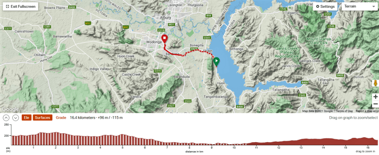
14-17 September 2021
180 kms (112 miles)
Are you one of those people that have good timing? Do things just fall into place more often than not? Do you just beat the rain showers? Does the perfect job come open just as you are ready to quit your current job?
Or do you have rotten timing? Does your planned holiday coincide with record-breaking rains? Does the perfect job come available just weeks after you’ve committed to something else?
I’ve personally never had particularly good or bad timing – I tend to find a bit of both. But I’ve known people who somehow just sail through life and doors always seem to open at the right time. I’ve also known people who bump into every obstacle out there and are always the one who gets caught in the rain.
This little ride has some very good timing. We’re released from lockdown on Friday the 10th. I hang out for the weekend completing some work for a course I’m doing. Then, Tuesday (14th) to Friday (17th) has a four-day window of good weather. It is also the week before VIC and NSW school holidays, so there’s not many people around. The following two weeks are likely to be a bit nutso, but not nearly as nutso as it could be since Melbourne will still be in lockdown. Those poor buggers are up to 235 days of lockdown so far in the pandemic.
This also sneaks in a ride before another bit of good timing. A few weeks ago, as predictions that Victoria’s COVID case numbers were going to get huge by mid-October, I started to really fret that my gastroscopy scheduled for 28 October might get cancelled. (They tend to cancel all non-emergency surgeries when COVID cases get big). Waiting that long was going to be painful enough; how long would I have to wait in pain if the COVID numbers surge?
So I did a bit of research and decided it wouldn’t cost too much of my rainy day fund to just pay for the procedure myself and have it done in the private system. This might bump up the procedure to the end of September or so. When I rang the surgeon’s office to enquire about switching to self-funded private, the receptionist said she could get me in on 27 September at the private hospital. But she needed some higher authority to do this. When she returned to the call, she had good news: they had JUST had a cancellation in the public hospital on 23 September and I could take that slotted time. Yes, excellent timing on that phone call!
So we’re sneaking in a ride the week before that procedure. I want to be home by Friday arvo, though, as that is when they are supposed to ring to tell me what day to get my COVID test before the procedure. But really, that’s our only constraint for the week, so let’s go!!
DAY 1 – 44 kms (27 miles)
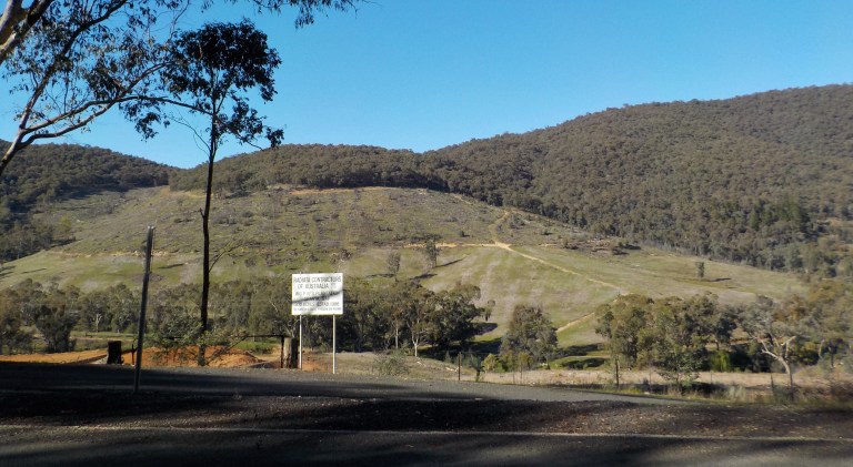
We’re heading for the hills. I haven’t been up this way in quite a while, and Lake Hume is so full that they are releasing water to make airspace for future rain events. They’ve released 300 GL of water in September so far.
The rail trail along the lake is a pretty spectacular ride when the dam is full (which is only once or twice a decade). The rail trail is also pretty open with not much shade, so spring is a nicer time to ride it. It just sounds like the perfect ride for this week.
Lake Hume is a massive reservoir in volume and surface area – it was once the largest reservoir in the Southern Hemisphere. It has 400 kms of shoreline and an area of 202 square kms. It can hold 3,005 ML of water with a catchment area of 15,300 square kms. That volume is six times that of Sydney Harbour.
The lake is a large C-shape with each “arm” of the “C” holding a different river course.

So the plan is to head up the Mitta Mitta River arm along the rail trail on Day 1 to see a bitta the Mitta.
Then, we’ll cross over the drainage divide via Georges Creek Road on Day 2 into the Murray River arm to see a bitta the Murray. The Murray River Road has been one of my favourite rides since we first moved to the area in 2004.
On Day 3, we’ll cross over the drainage divide again via Granya Gap and follow one of the Mitta’s tributaries upstream for a bit on a section of the rail trail that we haven’t ridden before. That section just got a critical bridge installed and a better surface laid for part of it in 2019.
Day 4 then just sees us retracing Day 1 to get home.
Of course, there is a moderate headwind as we pedal along the undulations of the trail today.


But wow, does the lake ever look good when it is brimming full. Climate change means this sight is going to become less and less frequent, and it’s not a particularly common event even now!

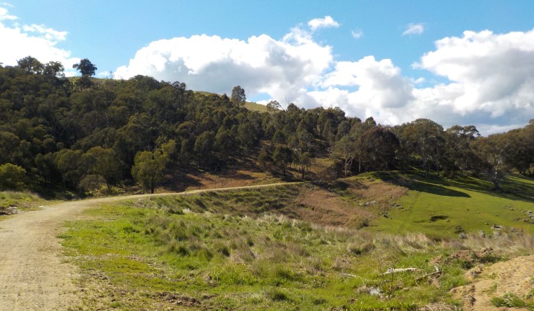
The trail weaves along the inlets and over the spurs of the hills. We’re way up high on the valley edge – which would be more evident if you took all that water away and looked down to where the river course actually lies.


The sun is shining. There are not many people on the trail. The magpies are strangely absent. It feels good to be on the bike. We don’t have far to go today, so I take my time and get in some horizontal resting at each of the boat ramp reserves along the way.


Just as I am thinking that it is amazing to ride 25 kms in September without a magpie swooping, a guy comes angling at me as he lets out that sharp cry and snap of his beak. I’m on a gentle downhill through here, so I kick it up to 30 kph. But he’s a pretty aggressive bugger and swoops very close to my ear several times and pursues me for a good 300 metres.
Hilariously, I see the sign they’ve erected to warn of the magpie long after he’s found me. Even more hilarious is that the magpie sign is just a laminated sheet of A4 paper attached to a little post that is only about half a metre high.
I can see a small picture of a magpie on the sign and a whole bunch of tiny 12-point text. It’s probably explaining that they are a protected species which you can’t harm and that they only swoop for a short period each year (it’s actually about 3 months, but they like to say 4 weeks). So you’ve just got to put up with it. The sign probably also gives tips to prevent an attack that aren’t really effective.
But who the heck is going to stop and READ that sign when they are being aggressively swooped by a medium-sized bird with a sharp beak and claws?! Really, just put a big pic of a magpie on there with the words, MAGPIE AHEAD. It’s not like we have any international tourists in the country at the moment that would be unfamiliar with spring-time bird attacks.
Just after that attack, I roll down to the Sandy Creek Bridge. It’s an impressive span over an inlet and doesn’t usually have much water under it. Today the water is high enough that the fishing boats can just barely slide under.

I note the once -bright red posts that are meant to be symbolic of smoke curling away from the train are getting quite faded. The Aussie sun is just so harsh!


Just beyond the bridge is another magpie who finds me long before I see the sign again. Then it’s just more uphill and downhill through cuttings, treed areas and open sections that parallel the highway. I’ve ridden this trail many, many times, so it’s a familiar pedal along the undulations. I lose count of the number of times I’m swooped.

I hit Tallangatta right on lunch time, but I’ve got all my food for the four days on board so I can minimize any exposure to other people and not need to go indoors at all on this trip. I don’t want to do anything to jeopardize the gastroscopy. Yes, I’m being paranoid… this Shire has never had a COVID case in the entire pandemic!


We head down to the park on the lake. Normally, it is a long, long way from the water, so it looks fantastic to have the water lapping at the edge of the grass. They’ve done some beautification works here by putting in a lot of nice plantings and upgrading the facilities and seating. It looks really nice and inviting – you could be so fooled into thinking this would be a very nice, temperate place to live with all the green grass and water around today!!


We find a spot along the water that’s got some sun and shade. I tether the guys out on their floaties and then lay down for a bit. It’s pretty quiet and there’s not too many people around. I’m enjoying the peace and letting the gut/back pain recede until….
One old man comes by with two obnoxious white fluffy dogs not on lead. They jump on me, scratch my legs with their claws and try to lick my face. I shove them away. The owner does not apologize. In fact, he doesn’t say anything to me at all. Ugh… irresponsible pet owners with dogs off-lead in on-lead areas are one of my pet peeves. I’m 90 percent certain he doesn’t pick up their poop either. Just because you think your dog is the world’s greatest animal ever does not mean other people will think the same.
The wild animals are putting on a much more impressive show, though. There are a couple of different species of ducks that cruise by. Several pelicans swoosh in for noisy landings before floating around for a bit and then taking off again.
And then I’m treated to the courtship dance of the great crested grebe. The birds face each other with head and chin feathers fluffed out. It makes their heads look like a dorky t-shape. Then, as they face each other, they take turns scrunching down their long necks, pushing their beaks into their chests or backs, then shaking their heads in a NO motion. Then the other bird does the same. They do this repeatedly for up to 3-5 minutes. Then they float around for a bit before starting again. This goes on for about 20 minutes.
I am definitely not a bird person, please give me trees or rocks any day. But to see a courtship dance while just hanging out on the foreshore was quite impressive!

Finally, I pry myself from the grass, head back up to town and fill all of my water bottles. Water shouldn’t be hard to find on this trip – but water not polluted with cow shit and fertilizers could be. So I’m taking four litres with me. I won’t be able to fill up tonight, so this water needs to last for two days.
Then we take off for a section of rail trail where I know I can whack up the tent at dark. It’s 8 or 9 kms from Tallangatta and the trail features more gentle climbs and descents through cuttings. The high water in the lake is a constant companion.

We cross over the Tatonga Inlet – the dam level has to be over 80 percent for the water to reach this far back up the river. There is snow still visible on the high peaks in the distance, but the cover is quite patchy. Winter is definitely winding down.

I lay down on the bench at the old council chamber site. It was a very impressive building for the day, but nothing remains but parts of the foundation and pieces of brick and render lying here and there.

This is where we’ll camp tonight. Usually I just camp next to the trail, but the grass isn’t too long yet, so I will set up the tent behind a tree, out of sight of a house over the road, after sunset. I’ll actually be camped ‘within’ the old building footprint.

So I lie there on the bench and doze and munch on some snacks. Somehow three hours goes by like nothing, and soon the sun is setting behind the edge of the hill just after 6 pm. We’re not far off daylight savings and the equinox. Time marches on, even though COVID has distorted all sense of progression.


After sunset I watch car headlights moving along the far shore, appearing and disappearing through the trees. I watch faster cars catch slower cars. When the cars have their high-beams on, I can watch the hillside vegetation all lit up as the car moves and then the imposing darkness when they flick their brights off when they meet another oncoming car.
What’s really cool is watching the cars cross the bridge over Tatonga Inlet. As the car headlights pass in and out of the trees, it looks like someone running with a sparkler in a straight line, particularly those halogen headlights that always dazzle oncoming vehicles. The best, though, are the livestock trucks that have the orange or red lights that encircle the top or bottom of the trailer. As they move along and the light passes between trunks and leaves of the trees, it looks like the trailers are lit up like sequential Christmas lights – each light flicking on and off in a row along the trailer.

Later on, I listen to the sound of water displacement as fish flop, flutter or plop, depending on how much air they gain on launch. Waves slop onto shore and recede. The stars appear and the satellites cut short or long arcs overhead, depending on trajectory.
I feel disconnected to the cars on the road – I’ve totally relaxed from work life. But I do feel connected to the water, the earth, the sky, the stars. As we approach the equinox, I think about how you can engage with that circular cycle of day and night and season when you disconnect from the linear timeline of work, eat, sleep, and set meetings for weeks or months ahead. There’s no SAVE THE DATE for the solstices and equinoxes as the date changes each year – it’s all about earth tilt instead of calendar time. I suppose the key to life is finding a way to stay connected to that circular timeline superimposed on the western civilization linear timeline. Work-life balance might be about staying connected to more than one timeline rather than divvying up fun between work hours. Or maybe it’s the ability to live in the moment over a lifetime… something no one I know has managed. But there will be more time on both the circular and linear timelines to ponder this… now is time for sleep.
Day 2 – 44 kms (27 miles)

Everything is sopping wet. The tent drips like a mountain spring. The air is crisp yet moist, and there is a moderate breeze as the cold air flows down the valley. Wisps and clumps of foggy cloud skim along the surface of the water in the wind.
I pack the tent. Wet. Dripping. My hands are so cold! It’s about 4 degrees after an overnight low of 2C or so. Brrrr…… But, oh, I am not complaining. I will take early morning frozen fingers any day over the sweltering heat of summer.
The first magpie attack comes just 500 metres down the trail at the Old Tallangatta Overlook. That is one unhappy bird.
We turn off the rail trail and take the bridge over the upper end of the lake’s reaches. Another magpie stands in the middle of the road ahead, flexed for take-off. As I ride past, he flies up and into the air and then dive bombs me repeatedly until I get to the other side. And that, thankfully, is the last attack of the day.

Our route rounds the corner of a large, grassed hill and takes us up into the Georges Creek valley. The road is quiet and I can hear the water trickling, falling, gurgling and flowing through ephemeral watercourses making their way to the main creek.

The rounded, treed tops of the ridge off to the right comprise Mt Granya State Park. We’re going to go around that ridge and its spurs and camp on the other side in the park tonight. Off to our left, the forested Jarvis Creek Plateau rises behind cleared spurs and hills. We can’t actually see the plateau for the hills in front. Had we taken off Monday instead of Tuesday, the plan was to ride up there and pick up some new tracks before camping up top. We’ve ridden and camped up there once before, but there is more to explore. Just not this trip.

I work my way up the valley. There’s a mix of large old gum trees and exotic, deciduous trees. The fruit trees are all in flower and the cedars are fragrant as the moisture evaporates with the warming of morning.
At the unmarked turn-off to the plateau, the road goes down to dirt. I’ve got good timing here, too. They’ve already done all the major earthworks and road construction. It looks like there is just drainage work and sealing yet to do. There’s no one working down here today.

There are some politics involved with this road, though I don’t know the story. I just know that they are sealing it at about 500 metres at a time, and on the other side of the drainage divide, it’s a mix of gravel and seal. Eventually they’ll have the whole road sealed, though the amount of traffic on this road is minimal. Somebody with influence must live along here somewhere.
Once I get to the top, there are two guys digging a trench, but that is it. They have a gravel truck semi-trailer parked on one side of the road, one guy is in a digger of some sort and the other guy has a shovel. The shovel guy says hi and then keeps digging. He’s the only person I’ll speak to, or see without any window glass between us, today.


Of course, when you get to the top, you get great views down to the lake. You also think you’ve got a nice downhill coming. You do, just not yet. The road drops to a different drainage, climbs out of that one and then drops you into a third drainage. So there is a fair bit more climbing to do. However, this is the easy approach. The other direction has all the staggered climbs, but at a much steeper grade – over 10 percent in one bit. I have previously done this road in the other direction, and that way is definitely more of a grunt.

I finally cruise down the final bits of gravel to the Murray River Road. This is definitely my favourite road in the region. It’s quiet between 11am-2pm on weekdays, and even on the weekends when the high-performance motorbikes and the unwieldy caravans come out, it’s never over-run. The only trucks using the road are on local runs or picking up livestock or milk from the farms. This is truly a gem.

I apply some sunscreen and then I’m off. There is little wind and little sound except for bird call. It’s a peaceful ride along the tree-lined road through open paddocks or along the ends of ridgeline spurs. The water is often just off to the left as the road curves and weaves along the shoreline. The treed peaks of the state park are always off to the right at varying distances. Sometimes their lower, cleared slopes feature lines of outcropping granite, some wet with water seeps today.

I only saw four cars on the Georges Creek Road. I’ll see less than 10 on this section of road today. It’s even quieter than I expected. Most of the time, I get bored with roads I’ve ridden before, and I always want to seek a new road to ride. But I never get tired of this one. We’re doing just a very short section of it today.

It’s time for some food and horizontal resting. I stop along the water’s edge near Wise’s Creek Floral Reserve. I set the guys out on their floaties and eat some peanut butter on rice crackers. Pain levels are average today, but I’m really doing far more than I probably should. I’m very patient with other people but never patient with myself.
The guys are really sloshing around out there. It is quite hilarious actually. They look like they are on a bumper boat ride and keep banging into each other. It looks like they are doing it on purpose.
This is one of the reasons I love having the guys along – it forces a bit of fun and play into my life. I’m a pretty serious person by nature, so my guys bring a bit of humour to my serious thinker/analytical side. Of course, those little pieces of fluff have been nice to have around on those occasions where I’ve sat out very severe weather in the tent. Their tiny hugs are a source of security when all alone in very adverse conditions.
Finally, poor Kermit has had enough and requests to be reeled in. He’s pretty wet; his shorts are soaked. Verne has faired a bit better. I lay them out on a rock to dry while I continue to lie there and enjoy the sun, the breeze, the quiet. Days like this are why I ride. No worries, no cares, totally self-sufficient and just out there with no need for anything but myself, my bike, the guys and the gear.

We continue on that gorgeous road. We pass the ferry. I’ve taken that quite a few times. Sometimes the water is too low for the ferry to run, but today the grumpy guy that runs it is probably enjoying it. There’s actually a large expanse of water to span to make the trip worth it. It’s a pretty unique sort of way to cross the river; you’ve got to go 900 kms downstream before you’ll find another ferry.
That’s definitely the way to sneak into Victoria though. There are no cops patrolling the border anywhere along the road today.


10 kms further on and we stop for another rest. The guys want a float with calmer waters and this looks good. It’s our last access to the water before we turn inland to head to the state park. I tether them out and let them ride little bumps of waves until the clouds gather, the wind picks up and the waves start to become more sloshy.

Ah, the serenity! I sure hope they can give me a definite diagnosis and there is an easy treatment for whatever is causing me so much pain. After four years of “everything looks fine” or diagnoses with no good treatments available, I’m scared that they won’t find anything wrong with me, even though I’m in a heap of constant pain.
Surely, that lumpy, burning pit of a stomach and that jabby pain in the right upper quadrant have a definite source. I really, really want to go on tour without constant pain! My energy levels are improving so well, I really feel it’s just my guts holding me back now (not withstanding COVID lockdowns).
There are a couple more hills before a long, gentle climb up to Granya. In my memory, one hill is sorta a steep, long slog. But when I get there today, it’s not bad at all. Perhaps in summer, when it’s hot and exposed, and I’ve ridden a lot further before this point than I have today, then that hill is more of an issue. I’ve been dreading it all day, so it’s nice when it turns out to be no big deal at all.

Granya is dead – except for a council worker slashing grass on the roadside near town. Granya is just a collection of old miner’s cottages and fibro homes in disrepair (that people are living in), a pioneer museum that’s never open, a memorial hall and public toilets. No one is stirring – but the town smells like that mown grass from the slasher, the woodsmoke from people heating their little, drafty homes, and a bit of grass of the more illicit kind.
I roll on through and then head the couple kms up into the national park. There are no caravans down in the camping area, but I head up toward the old scout hut anyway. I hate camping near caravans – the sound and smell of the generators, the sound of doors opening and closing repeatedly, the barking dogs, and worst of all, the smouldering campfire smoke that gets deep into my asthmatic lungs.
The track to the scout hut is just a few hundred metres long. It’s an MVO track which means no vehicles or bikes, so I walk the bike instead of riding it. There’s a large flat, grassed area next to the old hut that sits above a gorge filled with boulders of all shapes and sizes. I’ve camped here several times before.


I lay the bike down, grab the guys and their floaties, and my empty water bottles. We traverse the creek, clambering over boulders and logs, looking for a good float spot or two.
We then climb up above the well-trodden paths and find a spot to fill the water bottles. Further up is a large waterfall, but we’ve been there before, so we don’t bother.
We then head back and lie down on the ground sheet. The clouds have built and coalesced and there is little sun. It’s cool and damp. There’s just enough clear sky between the clouds that I can see down the gorge to the hills on the other side of the main valley. There is sun over there!

I lie there for the remainder of the afternoon watching the clouds move slower than a turtle. I watch the gaps between the clouds close and open as they shift ever so slowly through the sky above.

Ah, this is one of the perfect days on the road. Gorgeous scenery, no people, no services, nice temps, little wind, sunshine, quiet, few cars, all the food and water we need on-board and a campsite all to myself in the forest. These are the days you have to remember when the traffic is gnarly and the heat oppressive or the rain relentless.
Day 3 – 75 kms (47 miles)

It was another cold night. It took me awhile to get warm once I got in the sleeping bag last night, but once my body heat warmed up that space, I had a good night’s sleep. I love being cozy in the bag with my winter hat tucked down over my eyes and only my nose and mouth poking out of the bag. Definitely not for the claustrophobic, but infinitely better than lying sticky and sweaty on top of the sleeping pad with only a sleep sheet pulled up to your waist at most.
The tent is soaked on the inside from condensation, but a light breeze has kept the outside dry. More cold fingers from packing up, but not nearly as bad as yesterday. In summer, I would have been gone at first light, but when the overnight low is just 2C, it’s harder to force yourself out before dawn. Today, the sun will have been up for a couple hours before I head out around 8am.

It’s about 8 kms of climbing from the camping area to the top of Granya Gap. We’ve done this one quite a few times. Both approaches are a similar distance and grade. The road just winds up the edge of a creek valley, slowly going from about 240 metres to 535 metres over that 8 kms. I love climbing and I love squiggly roads, so it’s my sort of morning.

I tell myself to take it easy, to stick it in a super easy gear and spin. I can quickly get my pain levels to extremely uncomfortable with radiating back pain if I breathe too deeply. There is something about that sort of movement of the diaphragm that causes me a lot of issues. It also makes me quite nauseous.
So, this morning, I do the slowest ever recorded time up Granya Gap. I average just 8 kms an hour, I think. I spin. Spin. Spin. I never get my heart rate up much. The grades vary from 3-6 percent – I think most is 4.5 to 5 percent. It’s pretty constant. So I get in that super slow groove and go.

I’m happy with my muscles. We’ve still got 4 litres of water, winter gear and 2 days of food on board. That’s a bit of weight. But my legs are doing good, especially after 2 days of riding hills already.
But OH MY GOD is that so slow. Normally I would get my arse up there in under 40 minutes, so 60 minutes feels like forever. I am so impatient with myself. But there’s got to be some life lesson in climbing a mountain and patience, etc. My guts and fitness are forcing it on me today.

I tell myself to enjoy it. There’s no traffic around (I’ll only see 3 vehicles on the up or downhill and two horse trailers at the top). The temps are perfect for climbing. I’m not cold. I’m not sweating. I love this sort of road. There are good views over the steep catchment to the cleared paddocks below and the pale green of the eucalypts lining the ridges. Enjoy yourself, you fool, you could be at work right now!
I pass the harvested radiata pine plantation. It was planted in 1986, and for most of the time I’ve been in the region, this climb was a dark, shady one with closed in views with the pines enclosing the road on the right. Now that it’s been harvested, you can see just what a large area, almost the whole creek valley, that it had taken.
Finally, we hit the last straight. My body is in no sort of strife which is fantastic. But my mind is constantly berating myself for how slow we’ve climbed.

As I approach the gap, I see two ladies in horse riding gear speaking to someone in a 4WD towing a horse trailer. They see me and say good morning. I reply, Hello, but don’t stop to chat. I pull over on the other side of the road to drink some water.
As I’m ingesting the water, I overhear one woman say to the other, “Oh, my husband has a flash mountain bike that he rides a fair bit, but a loaded bike is so different. It’s so much harder. He’d absolutely die going up that.”
Thank you. I needed that ego stroke. For so long, I’ve felt so inadequate. I push myself as hard as my body will allow, but the rides I’ve been capable of completing for so long now have felt so puny and weak. So, after dragging my broken body up the gap today, that was a nice thing to overhear.
We fly down the other side. Well, maybe not fly, maybe it’s more apt to say cruise. But it’s a super fun downhill because you never need to use your brakes. You just consistently roll downhill at 35 kph with no effort. There are a few sharper corners where you need to find the right line to not need to feather the brakes, but if you’ve got the line, all you’ve got to do is the lean the bike in a bit more.
This is one of the things I love about riding – finding the right line, leaning the bike into corners and trying to keep as much speed as possible. This is an easy road and has so much flow, but I love to constantly try to improve my bike handling skills and take the corners as fast as I can.
I do have to brake on one turn today, but only because another vehicle with a horse float is going to meet me at one of the sharper corners. The line I need puts me 2/3 of the way out into the lane on the approach, but I’m not sure how much the vehicle and trailer might cut the corner, so I brake and take a more pinched and steeper line through the curve to keep well on the left side of the lane.
At the bottom, we have a choice, depending on how my body feels. We could turn right and start heading back along the reservoir today. Or we could head left and uphill on a section of rail trail I’ve not yet ridden.
It’s about 9.30am. My legs feel okay. My guts hurt but in a way that I think can be managed. The sun is out. There is little wind. The temp is perfect. There are no flies. So you know what we are doing: going up!


This section of rail trail climbs at a steady 3 or so percent grade for 28 kms up to Shelley which is the high point of the trail at around 800 metres. I’ve ridden the Koetong to Shelley section uphill a couple times as part of longer rides. But the section between here and Koetong has only been complete for a couple years. It is easily the most spectacular part of the trail, and I’m looking forward to this new section.
The trail takes off over the flat valley, crosses Dry Forest Creek and then begins the long, long climb. It is gorgeous as it winds up along the hillside. There are views over to distant 1000-metre tall hills and to the farms along the creek below.


There are deep cuttings to ride through and two tall trestle bridges, and a couple smaller ones, to ride around. It is truly a beautiful ride today with the hillsides all green and water bubbling down every watercourse.

Be warned – there’s a heap of pictures below. Please scroll through or click on to another webpage if it bores you. My dad would absolutely love to ride this trail, and he will never travel to Oz again, so the pics and everything below are a tour for him. If he can’t come over to ride it with me, then I’m going to try to take him along today.


Once we make the big u-shaped bend through a side valley, the trail takes us under the main highway. This section of the trail has lots of good shade as we wind through some pines and remnant native forest. The road sits up above and can be heard at times. The views are long and you really feel you are well into the hills now.


The plan for today was to ride as far as Darbyshire Station (or the old site anyway, there’s nothing left there). Just a couple kms after that the trail forces you out onto the road for a couple kms before the run into Koetong. I don’t need to do an up-and-back on the highway, so our goal is Darbyshire.
Once we get to the old station, my legs are pretty done. My guts are really done. No more uphill today – we’ll catch those few kms we haven’t done before on another ride.

I lay there in the sun for a good while. I listen to all the logging truck exhaust brakes as they negotiate the steep, curved road above. The clouds build and there is more cloud than sun after a while. So eventually I get up, knowing that the climbing is over, and as soon as we desire, we can be done for the day. I’ve got water and food, so whenever we see a spot where we want to camp, we can call it quits. I eyed off several places on the way up that looked good (and one of them is so good, I’m sure I will definitely use it in the future).
So we roll back down the trail. Whenever there is a sunny gap in the clouds I stop and rest and soak up the sun. It’s quite cool going downhill in the shade of the clouds at this elevation, so whenever there is sun, I stop and soak it in. The air temp is only about 12C.

There is so little effort going downhill. As we head back down the “big bend”, I can really see how the trains would have trouble making it up this bit during an icy winter day. It didn’t seem that much steeper than the rest of the climb on the way up, but we get up to 30kph going downhill without any pedaling at all. Woo-hoo! Too bad there are two gates that we have to stop to open and close or you could really let it rip!


We eventually get back down to the start. I didn’t really feel like camping anywhere up there – too cold to just sit around for hours. Now that we’re back down in the main valley, it is warmer and there are larger gaps between the clouds. Ahhh……
I stop for awhile between Bullioh and Old Tallangatta to let all the pain recede. I sit on some grass by the side of the trail with a good view over to the Jarvis Creek Plateau and the Georges Creek valley that we climbed yesterday. One magpie comes to pester me, but I eye him off each time he approaches, until he eventually gives up and leaves.

That’s the one thing about magpies – they can be aggressive, but they are actually cowards. They will generally only attack you from behind. (I’ve only been attacked twice from the front in 20 years). If you keep turning around to face them, they won’t actually swoop, they’ll just cry at you and hover above before taking off for a tree and coming back to try again.
I see a figure coming up the rail trail from the Tallangatta direction. Boy, he must be fit! He’s flying along! Nup. As he gets closer, I can see that he’s not really that fit, he’s just on an e-bike. He stops to chat for a bit before heading on.
He asks where I am staying tonight, and I say I don’t know. This is true, I still don’t know where I’m going to stop, even though it’s already 4.00 pm and sunset is at 6.00 pm.
But does any guy seriously think a solo woman on a bicycle is going to tell him the truth about where she is going to be that night? I think it is always an innocent question that they don’t realise is not really appropriate to ask. But it shows just how huge the safety gap is for men and women.
A guy doesn’t even think anything of that question, since he probably doesn’t consider safety or vulnerability in the same way as a woman. But there wouldn’t be many women whose ears didn’t perk up at that question and whose brain didn’t immediately come up with a deliberate falsehood. (This guy was no threat whatsoever, but no guy is ever going to know where I’m planning to camp that night unless I’m inviting him to camp with me).
I head on down the rail trail. I always keep my eyes open for potential places to camp when I’m riding. It could always come in handy for a future ride. I look for hidden campsites now like I used to look for kerbs to jump and obstacles to negotiate back in my BMX days. So I’ve got a few ideas to check out as we head back west.
Around 5pm, I stop to eat dinner and try to get my sleeping bag a bit drier, since it’s going to be dark before that comes out I think. I sit in the sun, sleeping bag in the sun, wondering if there’s a spot near the bench I’m sitting on that would be appropriate to camp. But when I go to investigate, there’s definitely a place I could put up the tent, yet it creeps me out. Nup. Never set up in a place that feels off – you’ll never sleep well. This spot is just too close to a pull-out near the Omeo Highway turn-off.
Then it’s on down the rail trail, chasing the sun down. I stop a couple times to check out some potential spots, but I’m not comfortable with any of them – either too close to the road or a home in the distance with sight lines to the spot. So on we go, the sun right in our face.
The magpie that chased me on the downhill on Day 1 is nowhere to be seen as I slog up the hill toward Huon. Maybe he’s already clocked off? He eventually flies up casually and alights on the branch of a small tree beside me. But he doesn’t seem too concerned – just eyeing me off through the last of his territory before flying away.
It’s just me out there as the sun sets behind a hill and lights up the hills on the opposite side of the lake. The grassy slopes glow red as pinks and purples settle over the water and sky. The smell of fermenting hay permeates the cool, moistening air. The approaching cars all have their headlights on.
I pass Huon reserve. There’s a woman there seated on the rocks. She is waatching the sunset and the colours on the water and distant hills change. Her reverie and peaceful view is interrupted by some arsehole bogans who have got a fire going and are using an electric saw to hack off a live branch from a tree to feed the fire. You’re not allowed to camp at this reserve – maybe they are just partying for a bit before driving home intoxicated. Sheesh.
I’m dragging now. The last few inclines have been way more than enough. We’ll end up having climbed a total of 900 metres (2953 feet) over 75 kms (47 miles) today. That would be a decent effort when I was perfectly healthy, so that is a good effort right now.
There are a couple places we could camp along the way, but we are close enough to Ludlows Reserve that we’ll camp there. It used to just be a day use area, but unfortunately they opened it up to caravans for overnight stays. It’s kinda ruined it as a day use area, and the local fishermen will park their trailers and utes right up next to the caravanners without hesitation to show their frustration with the change.
Of course, they have discriminatory rules about camping here. Tents are not allowed. There’s no reason for that, since there are toilets here and it’s a 24-hour only location. I can guarantee I flatten less grass than any caravan, camper or travel trailer. And nothing squishes too much down overnight anyway. It’s just discrimination.
However, there is a part of the reserve that they are revegetating that is cordoned off from traffic. It used to have a dirt loop you could drive down. No more. And there is a back entrance off the rail trail that means I do not have to pass by the caravans or duck under any metal ropes to get to that part of the reserve. So screw the authority, we are camping in the pedestrian only part of the reserve. Touring cyclists are special like that, right!?
Last light has lost its linger by the time I’m pulling out my wet tent. I find a spot under a big pine tree, confident it is too cold to drip sap on my tent. I get everything set up and the sleeping bag unrolled. It’s 7pm and the world has gone grey. Everything is damp and I’m worried I’ll be cold. But I am beat. Done. Finished. My legs are done. My guts are done. My butt is a bit done, too.
The wind picks up and the waves of the lake crash to shore. It sounds more like a beach with tides pulled by the moon than a freshwater lake far inland. But the waves are in some way soothing.
So is the sound of the frogs nearby. There’s a bunch of the marsh frogs that sound like Geiger counters, plus the pobblebonks. They are loud enough to hear over the cars on the highway, bonking away in chorus. I like those pobblebonks – though we did have one just outside our bedroom window once. And that was just too loud. Nigel had to go find him, partially dug under the fence, and relocate that one!
I fall asleep, have this one weirdo recurring dream I get about once a week, and wake up a couple hours later. It is quiet. The highway is void of cars. The frogs have given up for the night. But the waves still crash to shore.
I roll over, shift my hip on the soft bed of pine needles and go back to sleep. Day is done, gone the sun, from the lake, from the hills, from the sky, all is well, safely rest, sleep is nigh.
Day 4 – 17 kms (11 miles)
First light. The first birds call. I hear them in my sub-conscious. But I’m warm and still sleepy, so I do not rise. A bit later, before the sun crests the hills, I hear a man yelling out to a dog.
I’m awake now. I look out the door of the tent. The guy is rugged up and has two dogs on leads. Another black lab bounces about not on-lead. I lie back down and let morning drag me further out of sleep. It’s still before 6.30 am.
The dog comes over to inspect the tent. I hope he doesn’t pee on it. The dog walker moves on.

I’m out of the tent just a bit before 7am. The tent is pretty dry. It wasn’t quite as cold last night (3.5C), and the wind kept up all night, so there’s no dew. The waves on the lake are even bigger this morning. They are too big for the guys to have a float, so no relaxing start to the day for them.


I roll over to the main part of the reserve. There are 8 caravans there and two guys about to shove off in their fishing boat. I deposit my rubbish, note the neat new climbing structure for the kiddos, and then shove off myself.


It’s not far home today and I’ve got a good tailwind. Still, I am really nauseous this morning and pull over a couple times in the first 6 kms thinking I might puke (even though I haven’t eaten anything yet). There’s no one down at Ebden Reserve – the next one along the lake, so I go over and lie down on a picnic table for 30 minutes. I get some water down and that alleviates some of the nausea.
On we go toward home. My legs might be a little stiff today, but really not bad for the three days of effort. I’m home by 9.45am. Plenty of time to get gear washed and hung out to dry before the clouds come this arvo and rain comes tonight.

I’m really pleased with how well the ride has gone. My energy levels are definitely improving without having any stress or any commitments. I am getting better. Now we just need to get a plan to fix my guts.
The hospital calls me around noon. I’m to go get my COVID test on Monday. It’s my first brain tickle of the pandemic. Since I live alone, worked from home and don’t ever go to cafes/bars/restaurants, I’ve not had any exposure to COVID or any other sickness. I haven’t had so much as a cold in more than two years. I do feel sorry for some of the people I know through work whom have had multiple COVID tests as all the childcare bugs have passed through their household (Oz folks are much more into getting tested for symptoms than Americans it seems).

So I’ve already got some plans for the next ride. Just need to get the gastroscopy done Thursday, find out when I can get the follow-up appointment for results, cross fingers that we don’t go back into lockdown, and then head off to pedal once again. We are on our way back.
Great ride – and I enjoyed all the pictures! Also the guys floating experiences.
Covid test done. Now for the procedure. Let it find something and something easily fixable / manageable so you can get on the road.
When I look back at my life, I have to admit that I’ve pretty much had that “good timing” you described in the opening of this post with. And I sure am grateful for it, just as you were clearly grateful to have that big reservoir full of water for your trip. A body of water always adds something special to the scenery.
Speaking of water, the videos of the guys playing bumper boat and spinning around were highly entertaining. Of course your descriptive writing was also entertaining, but that’s ALWAYS been the case.
Good luck with the gastroscopy. I think you probably made the right decision to go with the private health option.
Glad that you are one of the smooth sailing folks in respect to timing. And glad you liked the guys’ floatie sessions – it’s nice to have a giggle now and again. And my timing…. got a call at 5pm Tuesday that my gastroscopy on Thurs has been cancelled and I’m back to the original 28 October date. Ugh. But it means I’ll head back out on the bike tomorrow. I was home today for the biggest earthquake I’ve ever felt, though. That’d be freaky in the forest. It was a 5.8 or 6.0 on the richter scale and was bouncy followed by quite shaky. Hope your transition from touring to normal life is smooth.
Hi Emily, Mom and I want to thank you for taking us on a “train ride” in The Waiting. It reminded us of all the rail trails we shared together for so many years. I always felt like I was riding a train on those conversions. The scenery along the one you showed is quite memorable and definitely relaxing. Thank you for sharing the entire ride with us, Love, Mom and Dad
My timing sucks!! I’m just now reading about your ride. I’m quite impressed with all the water.
I’m even more impressed with this:
Having climbed a total of 900 metres (2953 feet) over 75 kms (47 miles) today.
That’s quite a ride!!
Terry