

2-4 November 2022
75 kms (47 miles)
Total trip kms: 1100 (684 miles)
Day 26 – Millicent to Mt Gambier – Boandik Country – 75 kms
It’s raining at 5.30am. It’s raining at 6.30am. But at 7am, there is a break in the showers and I am rolling up toward the Mt Burr Range on wet pavement that’s been wet enough long enough that there is no steam to rise from the chipseal.
It’s cold instead. It’s only 6 degrees, and there is a pretty strong wind already. We continue our ‘late winter’ tour, even though we never have had a desire to tour in winter. I am not sure if I have had a single day on this trip where we hit the average high temp. And we’re 26 days in. Have we ever hit 20? The temps have all been pretty down low for some time.
But right now we are going up. The climb up the range is a little steeper from this side. But luckily, the traffic is lighter this morning than when we came into town, so it’s not stressful. And the wind is helping for now.
I’d considered going to the overlook for a different look at Mt Muirhead – that prominent volcano that sits on the edge of the range – but the reviews online suggest the pines have grown enough that there is really nothing to see. Nobody promotes the lookout anymore, and the signs directing you down the road which are visible in google streetview are not there anymore. So I give that a miss.
I’d also thought about riding around the trails on the edge of the Mt Burr townsite. But I’ve already been rained on twice in 10kms, the veg just looks like regrowth and plantings when I get to the trailhead, and I just feel like I should keep moving down the road.
And so we do.
I turn off on Overland Track – which is not a track at all. It’s a major sealed road through the range. There are a few native forest reserves along the way that are alive with bird and frog sound, but most of it is just industrial pine plantation. The only really interesting thing through here is seeing all of the dune sand that is draped over the older volcanics in a few road cuts.

Ho-hum. At least my feet aren’t soaked yet.
And then I start to think the effort to get up and down the undulations seems more than it should. And yes, it is. Because the rear tyre is going flat. We’re 22 kms into the day. It’s raining. Ugh.
Can I just keep pumping it up and keep riding? Probably not. We’re going to do about 75 kms today.
And then any ‘probably’ is replaced by no. By the time I get off the bike and go to squeeze the tyre, it’s already lost enough air that pumping it would last only hundreds of metres.
So I walk the bike across the road into a large grassy area between the road and pine plantation. I pull off the panniers, flip the bike upside down, gather all the tools and set about fixing a flat in the rain while it’s 7 degrees and the wind is slanting the rain at me sideways. I’m pretty sure I don’t need to develop anymore grit and resilience, but the bike gods think otherwise.
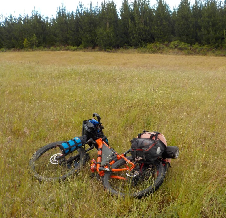
It takes me awhile to swap out the old tube and put in a new one. I can quickly find the hole in the tube and can see on the outside of the tire where the puncture occurred. But, for the wish-it-wasn’t-raining life of me, I cannot find what caused the puncture. I can’t feel anything in the tyre near that hole whatsoever. I can only find some grit that’s fallen to the bottom of the tyre. So I clean that out with the sock that was holding the spare tube.
It is so cold there is no give or flex in the tyre, so it takes me forever to unseat it and get a tyre lever under there. And then it takes me forever to get the tyre back on the rim at the end.
45 minutes later and we are back on the road. Not a great thing so early in the day when we were really hoping to get to Mt Gambier by around 1pm. I just sat out 3 successive cold fronts and troughs over 3 days. Trough 4 is going to make its way through today. The hourly forecast suggests the only part of the day that should be rain-free is between 8-10am – but the light showers are meant to get heavier after noon. Crap – we just spent 45 mins of the ‘good’ hours fixing a flat.
But that is the way it goes, and there is nothing you can do to change that. You can only change out the tube! So we proceed.
There are about 30 minutes of sun and mixed clouds as we turn off to Lake Leake on wet white metal roads. It’s more of that smooth hard clay/limestone stuff. For those 30 minutes, I revel being able to ride in some sun. The grass seems greener, the cows seem happier, the day seems brighter.

We have a steep climb up and over the ash rim of Lake Leake. It’s a maar – a lake that sits within an ash and/or tuff ring. Groundwater seeped down and came into contact with hot rock and magma. This created steam and an almighty explosion. It leaves behind a lake if the water table sits higher than the crater bottom. And it leaves behind ash and tuff (kinda like welded together ash) in a ring around the crater.
It’s sunny for the first five minutes I’m at Lake Leake. But the wind blowing across the lake is very strong, so it is very cold. I imagine the wind chill would be close to freezing.

As I had laboured up the hill to get here in the last of the sun, a group from a local high school had driven by. They are all in life vests, and there are canoes waiting for them. But I cannot imagine how they are ever going to canoe today because the wind is so strong I can’t imagine they would ever get away from the shore!
I wander around a little bit and surmise that it might be an okay place to camp when it is a bit nicer out, but not today when the ground is so wet (all the local run-off is running into the crater, so it’s soggy all round). And not when the wind is blowing a freezing gale across the lake and the thick clouds have come in.
Those poor high school kids are camping though, and their leader tells them to spread out and find a spot they like. Oh man, I’d hate to be the leader and trying to prevent 20 kids from getting hypothermic in the wind and rain, particularly those kids that look to be setting up tents on the soggiest ground.

I ride over to the high point of the crater on an adjacent road for another good look, and then start down the road to Lake Edward – another maar that is close by. The wind makes it really hard work, and there are some decent hills perfectly placed so that I’ve got that full-on headwind as I climb. Man, is it cold today! And wet. As usual.

We have Lake Edward to ourselves. It’s also a maar like Lake Leake. It sits lower in the landscape, and there are more trees around, so the wind is much calmer and it feels a bit warmer. I am so sad that the weather is coming in and that it is so cold. It looks like the perfect spot for the guys to have a float. They’ve never floated in a maar before. But they are dry because they are tucked down in the pannier and don’t know what they’re missing. (Don’t tell them!).

I do the walk around the lake, have something to eat, and then force myself back up and into the wind.


It rains on me pretty decently again. My mostly dry feet from this morning are no longer dry. The wind is still a very strong quartering headwind. And it’s all just pine and pine and pine.
And so I give my vagus nerve a little workout. Your vagus nerve is really important for calming you down and getting you from a sympathetic (fight or flight) to a parasympathetic (rest and relax) state. You can do breathing exercises that can help ‘tone’ this nerve. You can also hum or sing. Singing really loudly can help, too. You can also gargle. I’ve been practicing some of this since it was recommended by the integrative doc. My nervous system got all messed up with all that West Nile crap and I’ll give anything a try, particularly if it’s free.
But I don’t think you would call this loud singing helpful for the vagus nerve. I am not calming myself down. I am angrily singing Eurythmics “Here comes the rain again”. I am growling it out at the top of my lungs.
Roar. Roar. Hear me roar. It helps me get up the angst and energy to make decent progress in the rain and wind. It’s not helping my vagus nerve, but it is certainly helping me maintain a decent average speed.
After Eurythmics, since I can’t remember all the lyrics, I start in on Bob Mould’s “I fought”. This is a fairly recent song in his 40-something year career, but it has become one of my favourites. I scream/yell and growl out all the lyrics into the stinging rain.
Glencoe isn’t really a town. The primary school, rec reserve and CFA shed are down one road, and the post office and general store is a few kms down another. It’s a whole bunch of lifestyle blocks all spread out over the very green ground.


I stop in the general store for a mineral water (but end up with something that tastes like cordial – good and sickly sweet, but not good for your guts, so we won’t do that again!). The proprietor asks what she can help me with. I say to her, “Well, you could get rid of this crappy weather.”
She pauses for a moment, not sure what to say. And then I say, “and you can ring up this water for me.” She doesn’t know I’m on a bike. And it’s normal for them to get this sort of weather at this time of year (just not 13 straight days of it). When she realises I’m out in the weather, she says, “Oh, that makes so much sense!”
She had gone to visit her son in NSW. It flooded there. They had to come get her from a road and bring her to the property on a tractor. Then, her son decided to go for a canoe ride in the flood waters. When he returned, he asked her to pull him in, so he wouldn’t get so wet. She stepped down into the mud to grab the rope, slid and snapped her ankle. She’s now in a moon boot for six to eight weeks.
So I don’t really have anything to complain about I guess!


There’s a woolshed outside of town that is on the National Trust register. You can tour it with a key from the general store. It is an original woolshed and never mechanised. I briefly consider this, as it would be dry in there, and it’s raining again, but I’m already way behind where I think I should be with the heavier rain coming. So I take an external pic and hit the road.

I stop at a native forest reserve called the Honan Mint trails – named after a species of mint discovered here in 2008. It only grows in a 20km range around the site (probably because everywhere further afield has been annihilated by plantations). You can ride your bike on the trails since they are really just fire break trails mown into the vegetation.
So we ride around. In the rain. Shame on SA Forestry for the millions it makes off pine, yet its complete lack of any interpretive signs or anything to tell you about the native forest reserve and its plants. Since it is spring and every plant I see seems to be flowering, you’d think it would be a good time of year to see this famed mint plant. But there is nothing to tell you what to look for or what sort of habitat it likes. There’s not even a picture anywhere so you know what it looks like.

But I do see absolute monster-sized grass trees and manage to ride along skinny boardwalks without falling off, so I’m glad I took the time to stop here. This is the sort of thing I really enjoy and haven’t been able to do much yet on this tour.


It’s pouring rain while I’m at the bird hide. And the birds are all smartly hiding somewhere else. Nothing’s out on the water. I hide from the rain in the bird hide, too, for a bit. But I know it’s futile because there is more rain coming.


So back into it through a nice section of trail with overhanging swamp gums and stringybarks. The ground is squishy but the trees block the wind. Everything is vibrant green. There are always trade-offs.

I head on down Kangaroo Flat Road. I pass a sawmill and its scent of fresh wood. It makes me think of going to the lumberyard with my dad as a kid on “Saturday trips”.
A log truck comes behind me and I roll of the road onto the soft shoulder. Atlas has been so good on this trip. If traffic situations become dangerous I’ve been able to just roll off the road onto whatever is there, at whatever steep angle, with no worries at all. The log truck flashes his rear lights in the pattern that says “Thanks” after he goes by.
It’s absolutely pissing down with rain now. My feet are soaked. Again. And it only gets worse.
The road I thought I would take to avoid the main highway looks very, very mucky in the pissing down rain. I do not think that is do-able. I’m going to have to ride the main highway. Ugh.
We get out there. The road shoulder is an add-on, incredibly bumpy and only about 18 inches wide. There are hills. And there is heaps of traffic. The log trucks are going one way or the other every 30 seconds to one minute.
I am concentrating hard. I’m keeping a straight line in that minimal shoulder, and when the log trucks converge, I drop off into whatever crap and vegetation is on the verge. So not fun.
I’m pushing hard. Very hard. I’m doing 26 kph up the hills and 30-35 downhill or on the flats. The gusty wind that’s been so strong all day is now, at least, helping push me along. Whenever a truck, or inconsiderate car driver, passes by just off my elbow, the rush of air flings all the rain and vehicle wash into my back in an audible spritzing spray. Yuck!
4 kms. Six to go. In my head, I’m yelling out Husker Du’s Something I Learned Today. It’s one of my favourite Husker songs, and it’s directing all the angst from riding in dangerous conditions into something slightly more melodic in my head than “Fuuuuuucccccck!”.
Just as we are getting closer to town the rain backs off to mist. And then, all of a sudden, there is the old rail line. It has been converted to a rail trail and I squeeze hard on the brakes and duck across the highway to the safety. Phew!
Now that I don’t have to concentrate on not dying, I breathe a sigh of relief. The rail trail goes through all the industrial areas, but now I can have a good look at the crater rim ahead and get excited that I’m going to be able to tour Australia’s youngest volcanic complex tomorrow.

I take some deep breaths as I ride, square breathing on the flat trail with the wind behind me. That whole time I was trying not to die I was so worried I’d get another puncture. That is part of why I was singing Husker Du in my head – to keep my mind off that possibility. Because how many kms do you have to ride after fixing a flat where you couldn’t find the offender before you feel confident that you are not going to have another in the same spot?
I stop at the Railway Lands Park and pull out the Mt Gambier map so I can figure out a way to the caravan park.


I pass a bunch of gorgeous blue ribbon homes with gorgeous front gardens as I crawl up the volcano on Ferrers St. This connects to the main road. And then there is Blue Lake (Warwar), the lake at the bottom of a very deep maar. We ride alongside it on a very narrow stretch of road with lots of traffic. I hold up a bunch of it, but don’t feel too bad, because the speed limit is only 40kph through here. (The better option, with only a little bit more climbing and an extra 3.5 kms of riding, is to go around the lake instead).
And then that long, cold, windy day is done. The kilometres were hard-won today. Nerd Em is going to be released tomorrow. Right now she needs a hot shower and an extended time warming up in her sleeping bag!
https://ridewithgps.com/routes/41368558Days 27 and 28 – Mt Gambier – Boandik Country – 0 kms (well, we would have walked at least 20 and rode at least 7 to the bike shop and back and another few kms with a big climb back out of Valley Lake- but I’m not obsessive about kms, so we’ll say 0 since we didn’t progress anywhere).
The Dreamtime stories of the Boandik people say that the giant Craitbul and his family wandered around southeast South Australia looking for a place to settle. They camped and made an oven at Mt Muirhead (the volcano we photographed on the way to Millicent). But they were frightened away by the moaning voice of a bird spirit. They had the same thing happen to them at Mt Schank. They moved to Mt Gambier where they managed to escape the spirit and live in peace for some time. They made an oven here, too, but one day the water came up and put out the fire. They made three more fires, but all were put ohttps://ridewithgps.com/routes/41368558ut by rising water. These four ovens are the four lakes in the Blue Lake (Warwar) complex.
Check this link out for more information:
Geology says that the Mt Burr Range that we rode through is much older than Mt Gambier. It is thought that this range erupted about 1.5 million years ago. While there are the maars we saw yesterday, most of the volcanic activity along these ranges were fissure eruptions.
The volcanic complex at Mt Gambier was originally a series of low sand dunes that trended northwesterly. The volcanic activity started along the Tartwaup fault due to pressure from the Pacific plate pushing in parallel to the fault. This all went down around 28,000 years ago.
The first bit of activity were small scale maars (the first one is the cricket oval at a private school!) and an eruption of basalt lava. Then there was a quiet period. However, the groundwater in this porous limestone region ended up percolating down to the volcanic conduits. Yep, add water to hot magma and you get superheated steam and explosions.

The large explosions created the craters seen today, blasting through the basalt layer and depositing ash and tephra (like melded together ash) above the basalt. There is volcanic ash strewn in an 8 km radius from the complex.


I am in such geology nerd heaven. After all that rain yesterday (and on-off showers today), it’s like being in a geologist’s wet dream! I hike all of the trails, in and out of the Leg of Mutton crater and up to the Centenary tower.


Now, the way to do this, to get the most out of it: first thing, go to the Riddoch Arts and Cultural Musuem and see the free movie “VOLCANO”. It shows at 11am and 2pm weekdays, 11am on weekends. This is an excellent hour-long documentary that explains how the volcanic complex formed (with excellent visualisations!) and its context within the whole volcanic province. This will show you the sequence of events, and why things look like they do. Then you can go up to the volcanic complex and have a good knowledge of what you are looking at.
If only the Naracoorte caves had such an excellent video explaining that site! The Volcano movie was funded by the City of Mt Gambier – so good on them for investing in that excellent interpretive material. The video also explains the Dreamtime story of Craitbul at the beginning, too. I’m really impressed.
In the morning, before the movie starts, I wander all over the downtown area.


For the town to be the same size as Wangaratta, it certainly feels much bigger. I like the feel of the place, though with at least four wood mills in town, it’s not somewhere I’d want to live. The library is excellent, also. I spend a couple hours in there writing this up while they retension the front spokes on my bike. The guy at Daktari is run off his feet but still manages to squeeze in my bike and do the job for me over a few hours.


On Saturday, we make a move. And we supposedly have a few days to work with before the next lot of rain. Oh my goodness, a month into it and we might actually get a few uninterrupted days of riding.
My mom says she has been really enjoying the pictures of all the buildings. Well, okay. But that is not the sort of tour that I enjoy. Riding from town to town and taking pictures of buildings is the sort of tour that old, boring people do. And I’m not old and boring yet. I want to get out in the bush and camp and see trees and rocks and flowers and take a whole bunch of pictures of roads in the forest that will all look exactly the same to someone who wasn’t there. Leave the structures and the short rides on paved roads to the old and boring! Let’s go take advantage of some days without rain and actually ride instead of wait out weather. Let’s go get into the bush!
Glad the guys finally got a float. I bet they were feeling a bit down being stuffed in a pannier – not realising they were keeping dry!!
That person with the binoculars couldn’t even see the birds ! What a awkward pose.
You haven’t only shown us houses and town buildings – what about all the volcanic info above? Still, you want to get away from caravan parks, I realise that. Hope the chance comes soon.
5 good days and lots of time spent in the bush. Very few building pictures. Off to find a place to camp for the next rain event. Just when the ground was starting to dry a teeny bit….
great story thanks from an old and boring person who likes your photos of houses etc.!!!!!!!!!!!!!!!!!!!!!!!!!!!!!!
This version of the “Here Comes The Rain Again” cover is surprisingly good 👍 Thank you!
If you thought his version was good, you should have heard mine, LOL!
Oh really, glad to hear it 😆
Thank you for braving the elements to deliver some really interesting geological information. The maar lake formation process is complex but does leave a nice lake. I do hope you get a break in the next few days. Your fortitude is beyond description! Love, Dad
The last 5 days had good weather and we made the most of it. A bit of fortitude and a 15-hour day on the 9th saw me avoid having to ride in rain, wind and storms this morning. Sometimes you win… sometimes you don’t!
“For the wish-it-wasn’t-raining life of me”, I wish it would stop raining for you. (I liked your phraseology, so I had to use it myself.) I’ve been to the Turf Club a couple times, but it’s been about 25-30 years. That place used to give a lot of garage bands a place to play. One of the times I was there, I remember the band being so, so awful.
Well, keep plugging away. The weather is bound to change sometime.
Sounds like you need a new Turf Club trip, because 25 years is a long time 🙂 I used to like going to the $5 cover type shows in college, you often got to see a pretty good band that sometimes went on to do well, sometimes didn’t. I remember going to a Guided By Voices concert at a dodgy place in Denver (that is now in a gentrified area so much safer than back then). I thought Guided by Voices were just okay, but their opening act “V3” was really, really good. I even bought their album. They had energy and demons and were so loud, fast and full-on. Sadly, the lead singer suicided a few years later, but they made that concert ticket worth the money! I found this on youtube that may give somewhat of an idea of what they were like: https://youtu.be/DRtrFVtAgRo