

5-11 November 2022
385 kms (239 miles)
Total trip kms: 1485 (923 miles)
It’s the golden hour. The orange glow of the sun bathes the landscape in that low, soft Midas light. The slopes of the volcano ahead of us look like a jagged saucer set down in flat limestone plains and old stranded sand dunes. Ah, sun!
This morning, as I packed up in the pre-dawn dew, I couldn’t believe how bright the moon shone. Wow – how much progress has it made since I last saw it! After 13 straight days of rain, including mist, drizzle, pelting rain, cloud, cloud and more cloud, this is the first time I’ve seen the moon in almost half a month. It’s almost full – and we missed most of the waxing. What a strange trip this has been.
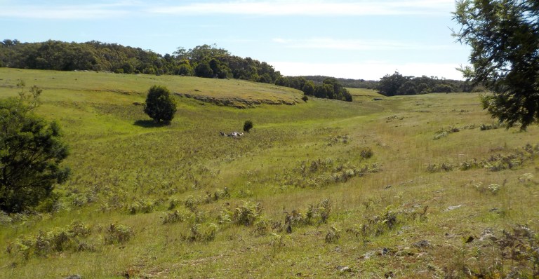
Day 29 – Mt Gambier to Lower Glenelg National Park (Bochra) – Boandik, Gunditjmara Country – 86 kms

But today will be sunny. Gloriously sunny and quite warm and humid. As we hike up the slopes of Mt Schank, on a series of 1138 terribly-spaced limestone steps, it is still quite cool. There is a whippy northeast wind up top that makes my nose run.
I had been surprised this morning at how much traffic was already out on the main road at 5.30am on a Saturday. I must have seen 20 cars in 13 kms.

And now, here at the volcano summit, I come across a local walking her dog at 6.45am. And then another guy, out for a morning workout, on my way down those terrible steps. That’s a lot of people for being 13 kms from anywhere.

I think you could take 100 people and have them climb up the trail, and four people would think it was the greatest thing ever because the steps were just perfect for their gait. The other 96 people would be like me – frustrated with being forced to take steps not quite at the pace and gait you’d like. They are proud of these steps though:
https://www.abc.net.au/local/photos/2015/09/16/4313730.htm


Our next stop is another sinkhole. We looked at a few of these in Mt Gambier (though I didn’t take any pics for you – they aren’t easy to photograph).
I crawl up and down the hills through the pine plantations. I get passed by a car. Of course, once I get to the sinkhole trailhead, they are there. Oh my god, I am so peopled out!! I can’t believe I’m having to share trails at out-of-the-way places before 8am. People everywhere! I’m very pined out at this point, too. I do not need to ride through another plantation to understand the economic landscape here.


I get to the turn-off (no signs, but on my map) for another one of SA’s piddly conservation parks. But there is a steep hill on the rough gravel ahead, and it is at this point I realise I’m sinkholed out, too. That’s the main attraction of that conservation reserve up ahead, but I’m going to give it a miss.
We enter another reserve later on, as we climb to the state border. It’s a mess of messmates and manna gums and a thick understory that hasn’t seen fire too recently. It looks so diverse even though it’s all regrowth of varying ages. Ah, how nice to be in forest after a fair bit of limestone plain, pine and agricultural areas.

We ride down the road that is the state border until we get to the trailhead at Dry Creek Trails Conservation Park. I couldn’t really find much info about this one, but it has 7-10 kms of trails. It’s also got a lot of fire tracks you could explore, but today I just do the 5km loop that allows us to see the limestone gorge of the Glenelg (Bochara) River, some grasslands and a bit of forest.

Ah, how wonderful it is to go for a walk in the woods, to feel the sun filtering through the trees on my skin, to get out in the forest without water dripping from everywhere. The temperature will reach a humid 27 degrees today. After so many days of 13C, doubling the high temp feels absolutely tropical. I could do without that humidity, but boy, does the heat feel nice.


We ride along the edges of the gorge to Donovans, a small cluster of modest homes, mostly from the 60s from what I see. It’s like a holiday shack town that never had wealth move in. I figure this village, and Nelson ahead, must be just far enough away from both Melbourne and Adelaide that it has so far escaped all the city money. Perhaps it’s even just a bit too isolated for the city COVID escapees.


The woman at the visitor information centre at Nelson is incredibly helpful. I ask if she thinks there would be any camping sites available in the national park. It only has a few designated camping areas that you have to pre-book, and since it’s the first nice weekend in ages, I figure it will be packed out.
She confirms my fears. But she’s seen self-sufficient touring cyclists before though, obviously, because she says, “I’m sure you could find something somewhere – at the edge of the pine or something.” Then she has a light bulb moment and says she thinks she could get me into the walk-in site at Battersbys.
There is a long-distance loop walk called The Great Southwest Walk that starts and ends in Portland. One half of the loop goes through lots of forest inland, then the other half of the loop is about 50 kms of beach walking. There are campsites with a shelter, picnic table, rainwater tank and fireplace spaced out along the walk. The one at Battersbys is right next to the main campground, so I could get in there easily. (You aren’t allowed to ride the walking track.)
So she books me in for $5.80 and then I go see the rest of the town. It’s a holiday village that has escaped the ravages of wealth. There’s a kiosk doing a roaring trade. Inside features two tight aisles of various goods, an entire back wall of fridges full of fishing bait, an ice cream fridge smack bang in the middle of where a zillion people are standing and waiting on coffee, and two small drinks fridges beside one of the counters. The place is also the post office. It’s getting covidy again, so that many people in such a tight place sees me back out of there quickly after I purchase an orange juice. Nelson also has a basic weatherboard pub, a couple basic caravan parks (no jumping pillows!) and a few blocks of modest homes. Maybe this is what Port Fairy once was minus the historic bluestone buildings.


This is where the Bochara River, which starts far away in the Grampians (Gariwerd) dumps into the ocean. The river comes out of the gorge and winds through low sand dunes in a large estuary. There’s river and beach frontages to explore here in that salty seaweed air. It’s a super popular spot for canoeing on the river and estuary, and even today in the off-season, there’s at least 15 people out there paddling around.


Away from the busy kiosk, it’s a pretty tranquil scene. I don’t know what it’s like in summer, but it’s nice and laid-back today.
Eventually we climb the steep sand dune out of town and then head into the national park. Ahhhh…. forest riding. No boring buildings today. The ‘forest bathing’ has been long overdue.
The only traffic I see on the road out to the campground is a fire truck that passes me a couple times after taking off on smaller tracks before returning to the main road. And I so pass a blissful 18 kms alone in the forest.

The trees overhang the road in some spots and bracken ferns overtake the understory for hundreds of metres at a time. In other sections not burnt as recently, there is a large mix of midstory plants, some of which are flowering in bright whites and pale pinks. There are no box trees like home, no pale green and leathery leaves. These are all bright turgid greens.

Atlas comes into its own. I’ve got four litres of water on board and at least 4 days of food. I’m pretty weighed. down. Yet when the road gets steep and the hard white metal gets crumbly, I just tear right through it. I would have had to pick my way through on the touring bike, but with this, I just ride right on through at speed. On a couple steep sections where the erosion lines run in parallel with the road, and there is no way to avoid getting into an erosion line at some point, the bike just slides right into a groove and slides back out. I don’t even have to brake. Woo-hoo! It’s a bit mountain-bikey and I’m so in love with my bike. It powers right on through even with all that weight on. I would never do 54kph downhill on stuff that rough on my touring bike. Good, good stuff. What a great day!
Many, many thanks go to my parents who gave my brother and me a bit of cash back in 2017. They wanted to see us enjoy something with the cash now, rather than just being a ‘cold handshake’ inheritance later. So I purchased Atlas, and my MSR tent and REI sleeping bag with that money. My parents also stored that giant bike in their computer room for 9 months until I came to get it, too!
I get to the campsite and a woman in her 30s is already there with her tent set up. She says, “oh, are you camping here, too?”
I reply, “well, I’m booked in for it.”
She is on day 5 of 13 on the walk. There’s another guy, Tony, that will be along fairly soon. They seem to be tag-teaming and passing and re-passing each other. She thought she’d have the whole trail to herself so has been disappointed in having to share campsites.
She is very nice to me and we have a good conversation about her hike, and the distances you can cover walking vs cycling, but I can tell she is not happy yet another person is invading what she thought would be a quiet, solo walk. I totally get it.
She then tells me that there is a group of 10 teenage girls on their first ever hike that will be coming later. She had considered trying to get to the next campsite because there are so many girls and they are so loud and noisy. But then she got to this campsite after 20 kms, sat down, and that was the end of going further.
I think this shared grassy area would be okay for about 5 or 6 tents – but definitely not 14, including mine. So I sit down at the picnic table and have a look at the map while I have some late lunch/early dinner. There’s no way I’m staying here tonight. It’s about 4pm, but sunset isn’t until around 8pm. Where could we get to?
I briefly meet Tony before I head back out to find somewhere else to plop down for the night. I’ve paid for a camping permit, so I won’t feel bad flattening some grass somewhere else, even if it’s not technically legal.

We don’t have to ride too far to find a nice spot for the night. We’re about 750 metres off the main road, and I can finally get the tent out to dry before setting it up again. We are in thick koala habitat here. I can hear a lot more than I can see, and all night long I’ll listen to those noisy buggers grunting, shrieking and sounding more like a rutting deer than anything you’d think could ever come out of an animal that size.
Day 30 – Lower Glenelg National Park to Cobbobonee National Park – Gunditjmara Country – 85 kms
Cold, cold fingers but the tent fly was semi-dry this morning. I’m certain it’s the first time we haven’t reached the dew point on this trip.
On down the rest of the river road through the forest and then out onto a sealed road that runs to Winnap. National park to the left of me, pine plantations to right of me, here I am.
It’s quiet as I ride the undulations. The river is over there somewhere, and on occasion we can see the break in the trees where the river cuts through below. The sun is slanting through the trees, too, as its morning ascent has just begun.
There is a steep climb away from the river in which we stop to pick up a Ford hub cap cover. My car is missing one, so maybe it will fit. Sometimes, the road provides.
And then there is a long, gentle climb up into the hills. We’re back into forest and away from the pine. After the road drops to another sinkhole-looking water body, we then have a steep climb up to a plateau. Go, Atlas, go. Go, Em, go.


It is steep enough that I spin the back tyre a couple times and have to put some body weight into each pump of the pedal. I would never have made it up this on my old bike. Too steep, too loose. I do have extra incentive to spin up steepness on this bike, though, because it is much heavier and more awkward to push than the old bike. I do find it is much easier to unweight the front tyre though on this bike, so I’ve been learning how to accommodate that. You can’t push/pull against the handlebars to put power into the pedal because the suspsension fork just absorbs that tension. I’m learning all the secrets of the bike. I’m so in love with it!
And I’m so enthralled with these couple of steep climbs, not because I enjoy the muscle torture, but because we are riding the wall of that Kanawinka Fault. Yep, we’re back to the east of that major faultline that gives this whole geoprovince its name.
We get up to the plateau and ride through open, swampy areas. The earth breathes moisture and it feels clammy in the coolness. The visitor info lady at Nelson told me not to go to this national park because it is all under water. It’s a swampy place on a peat-like soil and everything is saturated.
But I’m so glad I ignored her advice because the roads are fine. I have to ride through water a couple times, but nothing more than a few inches deep. And almost all of it is just fine. Yes, there is water running to the tops of every culvert, and every stream we cross is running very high. And yes, the ground all around looks soggy and the whole forest floor glistens when the sun angles just right on the puddles congregating in all the low spots.

BUT, it is great riding and there is absoutely no one around. I will see 2 cars in the first four hours of riding today! I just ride up and down the hills, the forest passing by in a blur on the downhills and with the chance to see the different species and age classes on the uphills.

This has only been a national park since 2010. It was logged within an inch of its life, and locals protested and rallied when the one contractor pulled out, saying there were no trees big enough left for sawlogs and another contractor came in to clear cut the tinier trees for chip. There was a lot of talk about ‘sustainable’ logging, but there was nothing sustainable about it, and many species were lost. If you are interested, a little bit of googling will bring up a lot about the contentious beginnings of this park.
But I am thankful for those protestors for giving me this peaceful forest to ride through, and for the forestry period to have created the road network. There has been a lot of burning done in the park, and it is quite open in many spots, and obviously still black in others, but give it 400 years (not factoring in climate change) and you could have magnificent forest once again. There really doesn’t look to be many trees over 75-years-old in there. So when you come across a massive, 5-foot wide old growth stump every now and again, it makes you twinge with sadness about all that has been lost, but also ponder in awe at what it would have looked like before they came after it with saws.

We pop out of the national park and quickly hook up with another small road that leads us to the road up Mt Richmond (Benwerrin – aka ‘long hill’). This is another extinct volcano, but it is so old that its features have eroded and it is almost completely covered with dune sand. Apparently there were two craters at the top and lava flows of basalt, but I can’t see any of that.


There is a really nice picnic area at the top, and quite a few walking trails. I skip the ones that go down the hill and climb back up, because really, climbing up the mountain once was enough. I do take the guys out on the ocean view walk where we walk through the skeletons of trees that didn’t survive a fire and then through more manna gum.
I hear a snake crinkle through leaves and then slither away off to my right and do that involuntary quick hop, skip and dance in the opposite direction that you do when very venemous things are very close. I’ve been seeing at least a couple tiger snakes a day on the road the past few days. They are more aggressive than some other kinds, so I’m perhaps a bit more jumpy than if I’d been encountering the more docile red-bellied blacks.

The track we take down the volcano is steep and eroded. I pick my way down the first of the hill and then just let it go. It’s a bit squirrely a few times, and I would have had to have walked the touring bike down some of it, but go, Atlas, go. Fast, and flying all over all sorts of rought stuff, but never feeling too out of control.


We ride some small one-lane sealed roads through that impossibly green countryside before meeting back up with the forest again. We ride down through the Fish Holes where the Surry River is not running holey today but running full bore instead. It sweeps the grasses down into long fingers of green waving back and forth in the current. It pushes detritus high onto trunks of trees holding fast in sandy soils. It breaks its banks and spills out over the low, adjoining ground.


From the river we climb to a ridge and follow this down to a campground. It is closed. Temporarily. Because an arse burnt down the dunny and so there are no facilities. Once I figure out that “temporarily” has been at least three years, I don’t feel guilty that I’m going to camp here even though it’s closed.
First, though, I take advantage of that sun and charge up my phone and my powerbank. I cook dinner in the lee of a fireplace while I scout around trying to figure out where I might camp that is out of sight of the drive. But then I just think, “Fuck it. There’s no good place to hide, there’s nice spots here, and if a ranger comes along, I’ll show them my shit bag and tell them there was no way I was going to be able to ride another 15-20 kms to the next town or campsite.”

Nobody else shows up. I swear they opened this national park just for me today. I enjoy a most peaceful evening with no people around. Ahhhh, how I needed some days like this.
Day 31 – Cobbobonee National Park – Gunditjmara Country – 50 kms
I’ve really been enjoying the peacefulness of the flogged forest. And I can’t head on today because I’m booked in for a tour of Budj Bim on Wednesday. So what to do with today?
I decide we’ll ride into town and restock some veggies and water. Then we’ll ride back out to the forest to a different campground and enjoy some more time in the trees.
I do hang out for a long time in the morning at the campsite, letting everything dry. I also order a new low-end tent and have it sent to a caravan park in Hamilton where I’ll meet up with it on Thursday. The poor MSR is done. The ground is not going to get drier anytime soon, and the tent wicking of moisture up through both the groundsheet and the tent floor is the death knell. Having to put the tarp in the tent just to stay dry is just too much. Even though I’ve done my best to dry it out each day, it has started to get mould growing within the tent floor fibres. (I can’t see it, but I can smell it). I’m extremely sensitive to mould, and I’ve been waking up with a sore throat and headache. After headache comes nose bleeds, and that would not be fun on a bike tour.
The tent has other old-age problems, as well, but they were just signs of decline and the need for euthanasia somewhat soon but not imminently. However, I no longer have confidence in the tent, and though that might be fine in fine conditions, the climate drivers are giving us very little of that.
There is much more rain to come later this week, and presumably through to the end of the year. Having a tent that is no longer reliable in keeping me dry is just not on when we are experiencing such extreme weather. So fingers crossed the low end North Face I find on sale, and which can be delivered in a few days, will be our ticket to sitting out rainy periods through the rest of our Western VIC touring loop.
Heywood is a noisy place at the junction of a few major highways. It is on the road to the port at Portland, so the trucks are pretty constant much of the time. There is just one street with shops, and that is only a few blocks long. One pub. One bakery. One grocery store. A couple takeaway shops. The cafe that was trying to bring a bit of Melbourne coffee culture to the country didn’t make it.


But the IGA is well-stocked and there is a nice picnic area along the river. So the town meets our needs.
The road we take back out to the national park is hillier, but more protected and scenic than the road we took into town. So I would say, use Kentbruck Road instead of the Canton Flats road.

The wind is in our face as we climb up and down and then back into the forest. I think I will try some new roads over to the next campground, because we rode most of the T&W Road yesterday. But after 4kms down the Boundary Road, I am stopped by a small lake that has formed at one road junction. So we have to retrace our steps and head back down the other road again.


Amazingly, between when I rode through yesterday morning, and 3pm today, they’ve regraded a whole bunch of the road. It didn’t really need it, I didn’t think. And you know what riding a freshly graded road is like. And if you don’t, be glad you don’t!
It is very soft and all of the rocks have been kicked to the top and sit just below or on the surface. The grader tyre tracks feel like continuously riding over a rumble strip. Ugh. That’s a slow go up and down the hills to Jackass Fern Gully campsite. It does give the big-arse rain cloud hovering over the area we are riding toward time to move off though. I only get sprinkled on for 3-5 minutes since I spent 25 minutes on that detour.

Jackass Fern Gully is another nice spot in the forest. I spread out over 3 picnic tables and get the solar panel charging my powerbank. This must have been a sawmill site in the past. And it must have been clearcut on a few sides not long before getting national park status, because much of the veg is just spindly sticks of trees. However, there is a nice little walk down to a gully to see tree ferns. The longer walk is not possible because of the river height, but it’s nice to breathe that deep, green air.
The woman at the bushwalking campsite said that there were a billion leeches in this national park, so I don’t spend too long down there in all the muck. Removing a leech does not sound like how I want to spend the evening.

Dinner cooks low and slow on the dregs of the methylated spirits in my fuel bottle. Mud, debris and gunk has gotten in the bottle and the fuel has gotten a bit diluted when I put the leftover fuel back in the bottle after a cooking session. So it doesn’t burn too hot or fast. That’s okay, we’re just cooking up veggies and rice noodles, and we’ve got all the time in the world.

There are no bellowing koalas here, and there are no other people, so we have another nice quiet night in the forest all alone. If there was a heaven, I think it would be a bit like that. I even get to have a bucket bath because the huge rainwater tank is full. But I think we deserve 3 good nights in a row after spending most of the tour trying to avoid hypothermia and also enduring 13 straight days of rain.

Day 32 – Cobbobonee National Park to Heywood – Gunditjmara Country – 26 kms
We linger in camp. We ride around the forest a bit more, and then we head into Heywood to get all set up for an early start in the AM. I have booked a cultural tour at Budj Bim that starts at 9.30am. It’s 26 kms away, and the tour is not cheap, and I don’t want to miss it if I have to spend 45 min fixing a mechanical, so we’ll be doing a 5am start to ensure we get there with plenty of time.

Day 33 – Heywood to Hamilton – Gunditjmara Country – 97 kms
The smell of chives floats to us from the high roadside grasses. The first of first light is a ways off and the light from my front light dances a frenetic jig on the pavement as the bike tyres roll over the chunky chipseal. Pockets of cool air sit down among the reeds in spots in the landscape where water and air collect. Birds call out and flit from tree to tree as the horizon’s light orange turns deep, over-ripe orange. Sunrise is still an hour off.

I need to ride six or seven kms on either the A-road or the C-road. The A-road would likely have more trucks but some sort of shoulder. I choose the C-road, hoping no one needsto be at work at 6am. There is a cluster of five or six cars just a couple kilometres out of town over about five minutes. I know I’m visible because the ones coming from the rear all give me the full lane and the ones coming toward me dip their high beam. And then that is all of the traffic until I arrive at Lake Condah 26 kms later.

We’ve ridden through the flats with gum plantations and dairy farms and one nice little section of state forest that has not been given to industry.
And so now we’ve got a couple hours to wait until our tour starts. I gave myself plenty of spare time in anticipation of forecasted 30 kph headwinds and the possibility of puncture. But, of course, the winds stayed low and the bike rolled fine.
Today we are taking a tour with the Gunditjmara to see the Budj Bim cultural landscape. They have lived in the region for at least 30,000 years. They were here to see the volcanic eruptions and then to take advantage of the lava flows after. They built extensive aquaculture systems using the lava that trapped eels and other fish. Such was the bounty provided by the lakes, swamps and hills, they were able to live here semi-permanently in villages of stone huts. You can now tour the area with a guide, though the stone systems are much more extensive than what you actually get to see.

I sit on the fence there in the early morning light, the only time in adulthood I think you’d ever call me a fence-sitter. I say hello to all of the staff as they arrive and then the tour starts at 9.30am. Thank goodness Simon, a PhD student from Adelaide studying dolphin interactions in WA, signed up to do the tour on his way home after a trip to the coast. They only run the tour with a minimum of two people.

Here is the link for the tours and cafe:
You can read more about this site here:
And here:
Braydon, the tour guide, is a tall, sensitive Gunditjmara man who tells us the creation story of the landscape and takes us to multiple sites to explain how the aquaculture systems worked.

We go up to Budj Bim (Mt Eccles) and he tells us about how the elders used to meet under the she-oaks at the ‘head’ of the mountain to decide lore. (When the white man came, they quarried into the back of Budj Bim’s head up until about 30 years ago which was very traumatising for such a sacred site).

Braydon also explains how ‘Country’ worked and how different clans moved through the landscape and other clans’ territories. He plays Archie Roach in the tour van and tells us how he was related to him and the deep, personal impact, as well as the impact on First Nations people more generally, that Archie Roach’s songs imparted. Braydon also tells us about the Eumerella Wars between the white settlers and the Gunditjmara starting in 1832. Some of the clans were completely wiped out, but those that survived put up such a fierce resistance that a Mission was established since the Gunditjmara refused to leave their land.
It is a very interesting four hours and well worth the time, money and effort to get out there. If you are ever in the area, the half-day tour is a must do. I’m sure the full day tour would be even better. There is a two-hour tour at the Lake Condah site, as well.
The only bad thing is that the wind has had time to whip up to fury proportions by the time I’m ready to head on at 1pm. It is a northeasterly at 30kph, gusting to 45kph and higher. I need to head northeast to go see Mt Napier (Tapoc).
Oh man is that is going to be tough with four litres of water onboard. I am only doing 8kph downhill at times. I think it is slightly easier to go east than north, but only marginally. We need to do another 50 kilometres to get to Tapoc. That could be five hours of fighting that whippy wind. But I’m not sure what else we’d do, so let’s just start heading that way and see how we go.

Well… we go slow. Uphill, downhill, east and north. It’s very tough work, but I feel really strong on the bike now. I don’t feel the weight of that water anymore. When I first tried out a fully-loaded bike with five litres of water onboard on flat ground at Jindera, I could not really even pick up the rear of the bike, and if gravity got ahold of it, it fell in whatever direction it was leaning. Now I can muscle the bike around with lots of water weight and my leg muscles are hard enough that I can pedal up all the hills without feeling weak.
It’s still a tough go as we crawl into that wind. But we get there. Kay by kay. I get really excited as we climb to the top of a hill and can look down into the wide Harmans Valley. It’s the main lava flow out of Tapoc and is a gorgeous gouge of rocky hummocks, wetlands and un-till-able land rolling down a wide swath like a river valley.

We also get to see the tumuli. These ‘lava blisters’ are only found in about three places on earth, so it’s really special to be able to see them, even though we have to sight them from a distance because they are on private land. Tumuli are hummocks of rock created when the lava flow spread and formed a thin crust. The accumulation of pressure beneath the crust caused it to buckle and crack, and lava oozed out, forming these unique structures. The tumuli measure up to 10 metres high and 20 metres in diameter.


There is a song by Archie Roach that Braydon refers to that talks about the mission rations. Hear that song below. And if you don’t know Archie Roach’s music, it is well worth exploration and going down that youtube rabbit hole. His most famous song is “They took the children away” about the Stolen Generation. He sadly passed away only a few months ago.
I am thankful for the farmers who planted windbreaks by the road. I’m thankful for remnant vegetation in road reserves. Anything to block that wind. I think maybe it has lessened a bit by the time reaching Tapoc seems achievable, but when I look at the phone forecast a bit later, I think maybe I’d just gotten used to be being blasted.

It gets pretty hilly in the last bits, but at this point I’m certain I’ll get to the volcano. The final bit of road to the park is more white metal in okay condition. But it’s pretty flat through here – so that’s welcome.
The approach road to the volcano is a bit over 4 kilometres. We ride through open forest with a forest floor full of bracken and thistle. I would love to see this after a fire when the bracken is gone, as you’d be able to see all the little volcanic details that only just breach the bracken now. I can see various lumps and folds and hillocks as we go up, but it’s hard to see the details among the green.

If you are ever over this way in a two-wheel drive, forget it. The “Coles Track” approach from the north is not two-wheel drive. Maybe the southerly or easterly approaches are better. Coles Track only has a couple steep pinches of tens of metres, but you are driving up basalt flows and volcanic junk and it is very rough. I would not have been able to pedal all of it on The Wizard. It is fine on Atlas but it is very mountain-bikey in various bits.
I’m tired, but excited about visiting another volcano. I finally make it to the carpark among really cool cuttings into the basalt at an old quarry. You are not allowed to camp here, but I’m so sweaty and tired and done with that wind. So I look around for a spot. It’s kinda mozzie-ridden if you get out of the wind, so I think maybe I can head back out to the Murroa Road and camp along there. The road reserve was quite wide. It does mean I’d need to climb the volcano now, though, and really I’d rather do it in the morning when I’m fresh. It’d be cool to see the sunrise there.
So I look at the weather forecast. Well, shit!
We are not going to camp here or along the road. The weather forecast of the rain coming in tomorrow afternoon is now going to come in tonight. I had some suspicions based on the advance of high cloud today that the weather was moving quicker than originally forecast. But this confirms suspicions. What’s worse is that not only is the rain coming earlier, but the crazy wind is supposed to just get crazier and there is also the threat of severe storms.


Sheesh, it’s 5.45 pm now. But we really need to do that 20 kms into town tonight. I call the caravan park (thank goodness I have mobile service) and say I’m booked in for tomorrow night, but could I come tonight. The office closes at 6pm, they don’t do late check-ins, but if I could get there by 7pm, then someone might still be around to give me the boomgate key.
Okay, that’s not going to happen. I remind her that I’m on a bike and can just duck under the boomgate. Voila! Problem solved. She says she’ll email me a park map with the site number. She also gives me some verbal directions and then says, “Good luck, that’s going to be a fight to get here.” She has no idea I’ve already gone five rounds of it to get to this point.
So we do the speediest ever ascent of Tapoc. Or as it shall be forever remembered – the slopes of thistle and bracken. I pull on my hiking pants over my shorts so that the boob-high thistles overhanging the path aren’t quite so painful and then take off up the very overgrown path. Up, up, up. Nigel rings me. I talk to him as I huff and puff up the ridge of the volcano.

And when we get up there: wow!! This is probably my favourite volcanic feature yet. Spatter cones, what looks like a fissure down below, obvious basalt flows and separate cones. Awesome views in all directions of that soggy landscape, the Gariwerd uplift and the other volcanoes in the distance. I do wish I had more time here. But I soak it all in for about 10 minutes, and then do the speediest ever descent, well, the speediest anyone’s done it without taking a fall.


Here is how the VRO website describes the volcano:
The Mount Napier volcanic complex includes a broad, low lava plateau, a number of well-defined eruption points and narrow, elongated lava flows extending along small valleys. The major eruption points are in the west of the area which is dominated by the cone of Mount Napier, the highest volcanic point of the Western District Plains. The main cone has a shallow crater with a well-preserved ridge of spatter on the western side. There are several parasitic cones with craters and at least 15 smaller basalt and scoria eruption points within a 2 km radius. These features are remnants from the last stages of volcanic activity and may be less than 10 000 years old. The bulk of the volcanic activity is in the Mount Napier area and on the lava plateau to the west. A major late eruption of fluid basaltic lava provided the source of a flow that extends for over 24 km along the valley of Harmans Creek. This flow has been constricted by the shape of the valley, in places being less than 200 m wide, and is almost 30 m thick. A variety of surface flow features (mounts, ridges and depressions) are well preserved and there are several groups of lava caves near Byaduk township. The caves are accessed through collapsed roof sections and display many well-preserved features left by the retreating and cooling lava e.g. lava ‘tide marks’ on cave walls, lava stalactites formed by dripping of congealing basalt and various jointing and flow layering structures. Near the limits of the Harmans Valley flow at Wallacedale, 13 km west of the Byaduk caves, are ridges or barriers of lava and unusual clusters of lava tumuli which are circular mounds or hummocks of rock up to 10 m high and 20 m diameter. The distal end of the lava flow is buried beneath sediments of the Condah Swamp which have been radiocarbon dated at about 8 000 years before present.
Then we head back down that approach road. Yahoo! Go, Atlas. This is very mountain-bikey riding over the basalt on the way down. We have to pick a line, and at times, I can feel the tyres slide on loose rock and then feel the tread catch. Woo-hoo! Yee-ha! It’s not technical like a rock garden, but it is continuously rough and there are big rocks and some ‘shelves’ to take on. Oh what fun!
Back out to the gravel road and we fight our way east as the high clouds make it feel much later in the day than it is. Onward, a bit upward. I keep glancing back at the volcano. All that effort to get there was so worth it, too.
We get out to the sealed road and then head northwest. This means the wind is finally a quartering wind instead of in my face, and we can make better progress. The road is mostly flat across open fields, too. It’s 12 kms into town. It’s almost 7pm. But we hammer it down. Go, Em, go.

I was so tired and ready to be done when we got to Tapoc. But I am so, so pleased I can push my body when I need to and not do any lasting harm. To ever be able to do a day like today again seemed impossible even 12 months ago. The weather has been so crap for this tour, but I truly am grateful to be out here and to have a body that can do this again.
I tickle that vagus nerve, but in a good way this time. The song that comes to my mind is one that was a popular a few years ago. So we sing this one out as we make our advance on Hamilton.
And then, it’s “Manic Monday” that comes to mind. Hahaha! I think I may have done it more in a punk style, because everything sounds better when it’s played faster and harder, of course!
There’s no one on the road. Everyone is home eating dinner I guess.

I roll into town. I’ve not seen many people all day, and I’ve been waging an epic battle against the wind, so it seems so odd to see people going about their ho-hum everyday lives as I get into some housing areas. There is a guy out for a jog, two ladies having a lively conversation as they walk their dogs, a kiddo yelling at his mother in the front yard that he does not like her, no way no how.
In all of the rush to climb the volcano and get back on the road, I did not pull up the Hamilton town map. But I rode through here a couple weeks ago, albeit not on any of these roads, and I think I might be able to follow my nose. I do get there without much trouble, but when I made the last minute decision to follow the Mt Napier road up to the highway, I should have gone straight. That road would have dumped me out right next to the caravan park instead of me having to weave my way over on a couple side roads and side walks.
It’s 7.54pm. We’ve done it. Sunset is 8.15pm. What a long, hard, but truly rewarding day. It’s weird to see all the people cleaning up their dinner at the camp kitchen sinks or sitting out under their caravan awnings watching TV. How mundane normal life seems when you’ve done a big day battling the elements. I think that is why it’s always been so hard to go back to ‘normal’ life after a tour, too. When you’ve been hitting endorphin highs like this most days, it’s hard to take that away.
By the time I set up the tent and have a well-deserved shower (wow, I’m one salty bitch today, ha!), it’s dark. 97 hard fought kms and a whole heap of things to think about from the tour and the climb up the volcano.
After my last post, my college boyfriend’s uncle, who I was so lucky to catch up with in Denver back in September, emailed this:
Sorry Em. Old is inevitable and it is not so great. Don’t let anyone tell you it’s the ‘golden years’. Boring is not inevitable though. I do find your building photos interesting since constructing them was my life’s work. I know you aren’t into that however and I wouldn’t want you to be. You are a nature girl through and through. You may find that someday you car camp or do shorter rides but you will always be out in the trees because that is who you are. You’ll get old but I am sure you won’t get boring. You have a fire in you that won’t allow you to get boring. You hide that fire well under that quiet personality, but anyone that gets to know you can see that burning bright. It’s what allowed you to get over your long illness and try all those different paths that eventually got you back to health. I find the old and boring tended to have been a bit boring when they were younger, too. That will not be you! Continue to be indomitable – I will be cheering you on from the sidelines of the old but not boring!
Ken is anything but boring. He is 76 and still competes in mountain biking and nordic skiing. He works a couple days a week for the Forest Service and still routinely rides 50 mile days on his bike training days. His heart health age is 53 and he is surviving a very rare kidney disease with very little loss of function that was supposed to kill him about 7 years ago. His food and fluid restrictions make mine look simple, like, “I don’t eat cookies on Tuesdays”.
So, no, old and boring is not inevitable. But if you see me routinely taking pictures of buildings when the weather is fine, please call me out and say, “Em! Stop being boring! Get back into the forest and ride some mountain-bikey roads”!
Day 34 – Hamilton – Gunditjmara Country – 0 kms
It rains. It’s a good thing I made the effort to get into town yesterday. Storms come through between 2am and 5am. And the crazy wind is even stronger. There is a brief period in the morning when the showers come and go which allows me time to walk into town and restock supplies and get back to the campsite without getting wet. T
Then I spend the afternoon in the TV room catching up my journal and trying to figure out where the heck we can head to sit out the next round of heavy rain from Saturday to Monday. My body does tell me we’ve had a few days of decent amounts of kays and climbing with a big load on, though. I feel pretty blah, and take a 2-hour nap, too!
I also spend a lot of time thinking about yesterday’s tour and try to get my head around 30,000 years of occupation, 6,000 years of a particular way of life and all the thoughts from the tour guide about dispossession and intergenerational trauma. There’s a lot to think through and it’s nice to have some quiet time to process all that was yesterday.
The forecast is for 4-15 mm of rain. We had 24mm by 5pm. Then storms roll through from 6-8pm and Hamilton ends up with 34.8mm in total. I really savoured those 5 days of good weather and tried to make the most of it in sights seen and kays ridden. We’ll be back to trying to stay warm tomorrow.
Day 35 – Hamilton to Cavendish – Gunditjmara Country – 41 kms
Again there is no sweeping clearing behind the cold front. Just more low cloud and soggy conditions. I pull everything out of the tent and put it on the concrete slab on the next site over. By the time I’ve laid out the ground sheet, tarp, tent body, tent fly, plastic sheet I had over the frame bag, and my panniers, etc., I’ve almost filled the slab! Amazing how that all rolls up, folds up and packs up and all fits on the bike in such a compact fashion.
I spent time yesterday looking for somewhere to the west, north or east within a day’s ride where I can sit out the next round of rain. I want a camping area that has access to water and shelter and that doesn’t cost an arm, leg and kidney in site fees.
And so that is how we end up heading to Cavendish.

I head out of Hamilton on the airport road. It’s long rollers over green open paddocks. Think of the long, shallow rollers of central Iowa instead of the deep and steep rollers of southern Iowa, and you’ve got an idea of the first 10 kilometres. The hilliest bits line up with that old volcano we rode over on our way out of town to the northwest a couple weeks ago.

There’s very little traffic out this way, and as the rollers moderate, we start to see more trees in the low points and some overflowing wetlands in the lowest points. There’s mostly sheep but some cattle. No crops. I ride through many kilometres of land owned by Jigsaw Farms. I’m not sure how many family members are part of this large landholding, but each paddock has a name, and there are lots of paddocks. I pass by Anna, Charlie, Ben, Hannah and many more.
The two roads on my map that looked like possibilities heading north once Hensley Park Road heads west are both looking quite mucky. They are DRY WEATHER ONLY roads and after 34.8 mms last night and however many hundreds so far this spring… I give them a miss.
Instead, I head over the main highway and onto Bulart Bridge Road. The landscape stays impossibly green and scattered with sheep being swallowed by spine-high grass. It gets hillier, though, as we close in on the Wannon River. This is the river we saw a couple weeks ago spilling over those two waterfalls in roaring glory.

There is a little picnic area by the river on this road – I’m sure you could overnight there without anyone bugging you. For us though, we just swoop down to the river and back up the other side. The momentum gets us halfway up the high bank before we have to put in some pedaling effort.
We then turn off this bigger road, where ‘bigger’ is all relative in the back blocks of Oz, onto a road that will lead us to Cavendish. Large areas of a blue gum plantation have been harvested and the stumps burnt recently. The ground is black and the remains of the stumps gone all bushy from regrowth. The smell of burnt wood, burnt bush, burnt gum seems so incongruent when the other smells in the air are moisture, mud and muck. I am unsure if I’ve ever smelled burnt wood in association with green growth instead of brown dry dust.
The mist and drizzle have been on and off all day today, though the misty bits have gotten heavier as the day has progressed. The guys have had to go in the pannier. Sorry guys!

The Dundas Range rises off to the left though it is only visible as a dark hill outline through the mist at times. It seems an odd placement rising from the tablelands. I must do some research to see if it is an outlier of the same sediments that make up Gariwerd, or if it is something else altogether. Hills on top of a dissected tableland seem a bit odd.
Cavendish is a bit busy on the roads. It is at a junction where you can go west to a big reservoir and a town called Balmoral. You can go east to Dunkeld and more of the Grampians or north to Horsham and other bits of the Grampians. South sends you to Hamilton.


The river is out of its banks and swirling over parts of the floodplain. The water is dark, almost black, and it almost fills the lowest terrace of embankments. The Settlers Walk is covered in many places, and there are overlook boardwalks that are underwater. I imagine this would be a very picturesque location when the river was within in its banks and the scattered gums provided dappled shade along the grassy banks.

It is Remembrance Day and there has been a recent, as in probably 30 minutes ago, service at the War Memorial. Next door in the Memorial Hall they are having their annual Fleece and Flower show. It’s an arts and crafts and county fair sort of thing inside the hall where all the locals have submitted entries for judging. You can get tea and scones for $5, and there will be a BBQ dinner from 5.30pm. So the little town perched there on the riverbanks is jumping. But that all looks too crowded for me now that we are in the exponential growth phase of the 4th COVID wave.
I roll down to the campground. It is on the banks of the river. It is owned by DELWP but leased by a Committee of Management. There are eight powered sites and an open area on the high bank, and there is riverside camping on the low bank that is all under water now. I ring up the caretaker and he says he’ll come by in an hour or so and tell me where I can camp.
I fix up some lunch on the stove with the final crappy bits of metho and then meet the exuberant caretaker. He shows me where I can camp and tells me that I should text him if I end up leaving earlier than Tuesday. He says he’ll bring me back the difference in fees. I tell him that won’t be necessary. At $5 camping fee per night, if the penalty for leaving early because the weather is decent is $5 or $10, then I am more than happy to forfeit that cash! I will take one for the team – for the soils, for the plant life, for my dry/wet feet. Oh yes, I’ll pay $5 per day for good weather! Besides, all the money from the camping area supports upgrades at the recreation reserve, so it’s a donation instead of cash loss to a corporation. (The forecast doesn’t look like I’m going to get any money back though!).

I set up the new tent. It is tiny – it means it when it says it’s a one-person tent. You have got to be real organised in there and you need to be very bendy (sorry, Tony, I don’t think you’d be ‘pliable’ enough for this one!). But it is definitely cosy and it is definitely warm. And my panniers above my head make a great pillow. The fork bags go on either side of my legs down the end. I would definitely not want to be any wider or taller than I am though to fit in there. Let’s see how claustrophobic we feel by Tuesday! But if it keeps us warm and dry until we get back to Albury, it will have been a very solid and worthwhile investment!

Nice to see you out on the gravel again. You made the most of the dry days before the next wet front. And even nicer to see how you have bonded with Atlas.
The North Face looks as small as my 1 person Zempire and is the same colour. You might be right about my pliability!
Hi Tony – The little North Face has been good so far. I actually looked at a 1-person zempire in my searching, as well as an Alps Mountaineering and a German brand I’d never heard of before. The zempire had less waterproof rating than the North Face and crappier poles for a similar price. It also had to be ordered from Amazon (as did the Alps tent) and wouldn’t get to me in 3 days. I try very hard not to support Amazon if I can help it since it is shitty to its workers. So that left the North face and the German one. The German one looked more fiddly to set up and had an extra pole, so I went with the North Face.
I ditched the MSR tent body and poles in Cavendish but I am still carrying the fly. It does leak, but it covers the bike and my gear really well. I don’t normally worry about covering my bike if it’s getting rained on overnight once a week or so. But with the nearly constant rain and drizzle, I don’t mind carrying that little bit extra to be able to keep the big dumps of rain off of it. It is certainly the weirdest, most consistently terrible, weather I’ve ever ridden in!
great great great!!!!!!!!!!!!!!!!!!!!!!!!!!!!!!!!!!!!!!!!!!!!!!!!!!!!!!!!!!!!!!!!!!!!!!!!!!
Hi Em, Thanks for another interesting geology tour of the volcanos. And especially thanks for weathering all the touring difficulties in order to show all of us how the island was formed. Glad you got some nice weather days along the way. Love, Dad
Thanks, Dad – really treasuring any decent day that comes along for sure! THis past week I’ve been back to some geology I’m familiar with and got to enjoy some nice big climbs.
I’ve never been able to figure out Suduku. My go-to is the New York Times Daily Crossword. I’ve loved that thing for at least 35 years. It’s especially fun to solve in a tent.
Suddenly, I’m REALLY starting to feel like I’ve slipped into the depths of old peoplehood. I’ve taken more pictures of buildings recently than in past tours. I guess that’s what happens to us oldsters–along with deteriorating eyesight and the urge to yell, “get off my lawn.” LOL
I started doing Sudoku because it was in the lift-out magazine with the weekend paper. When we first moved to Albury, I would go with Nigel out to the reservoir as his spotter when he was out on his Hobie catamaran. So I’d read the paper and do the Sudoku while he was out on the water. I don’t seek them out now, but do them when I come across them. It’s really just a process of elimination to solve them. I think crosswords are something you get better at over time. Since West Nile, my word recall is not so good anymore, so I don’t think it’s a good time to take up that past-time. I can see the appeal though, especially while kicking it back at a campsite.
The ‘taking pics of buildings’ is just a symptom, lol. It’s like high blood pressure or cholesterol… maybe just a sign to rethink what you are eating… or taking pics of. There’s nothing wrong with riding from town to town and taking pictures of buildings. It’s just a boring way of riding, and I’ve worked too hard to get well, to be relegated to that at this age! I will take pics of buildings as I pass through a town, because there are interesting buildings around, but if that is ALL I’m taking pics of…. then the tour kinda sucks… or I am old. The website is “ramble out yonder” not “wander about close in”. I like to think exciting tours are like a take on the Back to the Future quote, “Where we’re going, there are no roads… or buildings”. Just give me view-blockers and a big climb, thanks 🙂 Let me do the building pic thing 20 years from now…. I think you have a nice mix of campsites and buildings in your mini-tours that you’ve posted. You do a lot with the confines of sticking close to home.