

Saturday, 14 Jan, 64 miles (103 km)
So the weather forecast for the weekend is good! A big cold front swept through Friday night and lowered the temps from 35C (95F) to a predicted high of 28C (82F) for Saturday. Sunday has a predicted top of 31C (88F).
I flirt with the idea of an overnight ride. But all the interesting places to go will still have a zillion people on summer holidays. I can’t really find a route with a good overnight spot that excites me in the less-interesting areas. Plus, I need to spend Sunday getting well-hydrated. I went in for my yearly blood test in December the Monday after the hot, long overnight through Adelong. The blood test came back with slighly elevated creatine levels (easily affected by dehydration) and the doc wants me to do another test to be on the safe side. So I want to be well-hydrated this time around!
So I have a look at the map further and find some blank areas on the map that I’d like to fill in. There are plenty of gravel roads over near Brocklesby that I haven’t done (mostly because the roads are in Greater Hume and Corowa Shires which tend to have shitty roads).
So I head off at 7am into the wind and up to Burrumbuttock. It is pleasantly cool which is so nice after many mornings so far this summer that have had low temps measuring what I prefer as a daily high temp!


About 4 kms past Burrumbuttock I turn off on Iron Post Road. This is a new one for us. It takes us up into the rolling hills and crosses the old rail line twice. We cut up and over the hills – the rail line weaves around. This area has some tightly bunched hills with deep valleys and tiny, ephemeral streams.

The Iron Post Road turns into the Orelda siding road. There are 4 houses in this 7 kms. I manage to get passed by 2 cars coming or going from properties which means I encounter 50 percent of the local population in 40 minutes. The road is pretty narrow and the surface is mostly shitty, but I enjoy the climbing, the views and just being outside in temperatures below blast furnace level.

We got about 10mms of rain with the cold front last night. That’s fantastic – it is not highly unusual to not get any rain at all in January. It does mean, though, that the surface is a bit soft this morning to start.

We roll on upwards to long views and careful descents on the variable surface. No flying along today – too many corrugations and rocky angular road base!
We eventually get up to a section of road where a tornado came through in 2015. Tornados are pretty rare in Oz but do occur on occasion. There are a lot of dead branches and furry trees along the road reserve, and there are still bits of metal crumpled up among the trees that came from the adjoining property. You can look down the hill to some other furry or limb-amputated trees down on the main road. Further along that road, but not visible from here, is more tree damage. I’ve ridden that road before and was amazed that you could so easily pick out the tornado path at that time.

We roll on through Brocklesby (I came through here on my birthday ride last March) and then turn off on a new road for us that leads up to the old locality of Goombargana. More gentle hills and flat plains – all brown and harvested and just hanging out for the summer. Our plants more or less ‘hibernate’ in summer instead of winter here. You would, too, if you were here in the heat and dry.
We roll along through more valleys and climb to the top of more hills. The road surface continues to be mostly crappy with some good sprinkled in. There are more nice pastoral views over harvested fields, rough, tufted grassy paddocks inhabited by sheep and cattle, and scattered remnant trees.
It’s a good ride, but it’s a tough one. Today the high temperature will only reach 25C (77F). It’s the first time we’ve had a high temp below 30C, since early December. But the price to pay for a decent temperature is the wind behind a major cold front. It was already blowing at 15kph (9mph) at 5am today, and the whole time I’m riding it is blowing at 20-25kph (12-15mph) with gusts to 35kph (22mph). That’s okay for a bit, but very tiring when complemented by gravel roads in not-so-great condition and hills. It is also just downright annoying to get blown around all day. Sometimes I feel like I’m just out here as a chore when the wind and road condition combine to be pretty crappy. But most of the day is good… there’s just a few times when I think, ‘I could be home on the couch!’
I roll into Balldale. It’s a super-sad little village with not a single home in good repair. There are some very interesting, original cottages but they are mostly in poor condition. Last time I was here, in October 2015, the tiny ramshackle cottage that housed the post office appeared to still be operating. Not so today. Last time I was here, I sat, had lunch and relaxed for 45 minutes in complete silence. There was not a soul to be seen until I saw one person on my way out of town. Today, again, there is not a soul to be seen in the 10 minutes I’m heading to the toilet and then examining the maps. It is actually a little creepy.

I head south out of town to pick up some new roads. There are some swamp symbols on my map down this way. I’m hoping to see some big old gum trees hanging around the edges of the wet areas – though it’s probably too late in the year to see much water. On our way there we pass through a state forest that is completely flogged – even the remnants of the remnants have been taken down, so all that remains is scrubby bush and spindly stands of recent regrowth.
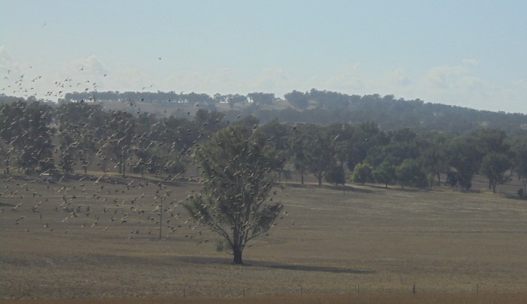
The ‘swamps’ are a disappointment. There are no big gum trees left – it’s all been cleared. There are sheep grazing the bits that would hold water, and there are plenty of birds flying around in the puddle of water that remains (if we hadn’t had record rain in spring, this would be totally dry by Jan). But I was hoping for big trees….

However, Gum Swamp Road is in great condition, and that pesky wind is a quartering tailwind for the first time today. So we fly along, and for the first time today, the flies can actually annoy me as they try to land on my face out of the wind. We cross a wide, flat plain between the gentle hills. The temp is still great and the wind makes the evaporative cooling very efficient today. It’s nice not to feel sweaty and sticky!

Onward. We’ve turned back north and east – on the return toward home. The wind is more of a help now, but we rarely get a direct tailwind. It’s enough of a cross or quartering wind that the flies aren’t much of a nuisance very often. I know when that wind is directly behind me, though, by the presence of the flies all about my face.
We climb over some more harvested hills and down into the next wide, flat plain. We see one 4WD in this – a guy out trying to get a sheep back into a paddock. But it is mostly a car-free afternoon. It’s after 12pm and the temp is still decent – amazing!


We go climbing through the last set of hills – the Bungowannah Hills – on roads we’ve ridden many times. I can tell in my legs that I haven’t been riding many hills in the past month. My head is also telling me that we didn’t bring along enough food today. Slowly, my head gets dizzier and dizzier until it feels like it is not really part of me. I feel really odd and my thinking is slow. Ugh. I’m not so far gone that I can’t convert kms to miles in my head (my map is in kms but my bike computer reads miles), but I’m not in good shape. I have 9 miles to get home.
I continue to deteriorate and my speed slows considerably. I really don’t feel that great. And now I’m out on the fairly busy road. Drivers are generally good along here – but there’s no shoulder and most people drive a fair bit over the speed limit of 100kph. It’s not good not to be alert on this road.
I struggle on for 5 miles getting dizzier and dizzier. Finally, I pull over 4 miles from home on a side road. I sit in the shade, take off my helmet and realize just how dizzy I really am. Whoa. I lean back on the embankment and let the world rotate faster than it should. It’s as if I’m viewing a time-lapse of the trees and sky above me. I look through my pannier again, just in case I put something else to eat in there that I don’t remember. Nothing. Oooh, not good. I can’t call Nigel to come get me – by this time in the afternoon he is usually not fit to drive. I can’t walk home – the road is too busy for walking beside a bike. Maybe if I just sit here a while, I’ll feel better….
But really, sitting is not going to improve low blood sugar. I need food. I decide to have a look in my Camelbak for some long-lost bit of something from a previous ride. I very rarely carry anything in the Camelbak other than water – but on occasion, when I don’t ride with a handlebar bag or pannier, I’ll stash a spare tube, tire levers and a snack in there. I rifle through the depths of the Camelbak, and the road gods deliver. Down in the bottom is a much-crumbled package of breakfast biscuits from who-knows-when. Thank fucking Allah.
I gingerly eat those cranberry cookie thingies and sit and wait. Within 10 minutes, the world stops spinning. My head reconnects to my body. It is amazing. I feel totally fine again. Oh, I’m still hungry, but the time-lapse has ceased and I return to real-time. I don’t even want to know how low my blood sugar crashed! But at least I didn’t crash.
I get back on the bike and the last four miles go by just fine. My speed returns and all is good. I stop at the little supermarket on my way into town and forage for a few things – mushrooms to go with dinner tonight, a choc milk (of course!), and some very good value on ‘reduced to clear’ steak and pork for Nigel. I resist downing the milk then and there.

Sunday will just be a short ride on the 10-mile loop so I can clean up all the flowerbeds at home and stay well-hydrated. If I can get all my errands done in town early on Monday, I’ll try to get in a 30-mile loop before it gets too hot (predicted high of 34C – 94F).
We didn’t ride all that far today, but I’m totally exhausted when I get home. I guess we can tell I’ve lost a bit of fitness over the past month of heat, and that the wind took more out of me than I expected!