

Holbrook – Little Billabong – Lankeys Creek – Jingellic – Thologolong
Saturday October 8, 2016, 77 miles (124 km) – Total so far: 1,996 miles (3,213 km)
There are only two good days for the ride before more rain comes through. This means, in the time available, I can’t get in a complete loop from home AND get in the new roads I’ve got planned. So I get a lift to Holbrook to cut off 45 miles. Dear husband drops me off at the side of the road and looks relieved when I say he doesn’t need to wait on me to load the bike. So I get a hug and kiss and then I’m left there with a pile of panniers, a front wheel and a bike.
Once loaded, I’m heading off just on 9.15am. I ride through town, over the freeway and up the Wagga-Holbrook Road past the airport. I’ve ridden this before so there’s no surprises – just chipseal, bright green pasture and fields of wheat, canola and barley (I think). There are a couple of magpies who chase me down the road, but they are the only attackers today. I guess the country birds are more civilised than the suburban birds.

Six or seven miles up the road we turn off on Kanimbla Road and then immediately take a left on Stonehaven Road. We follow this road up a long and winding valley that is cleared and full of pasture and canola. The road heads up gently at first, then rounds a hill into a narrower part of the valley and then starts climbing more seriously. Up and up we go. There are a few little downhills but then the climbing does some serious steepness up through the bright, tall, waving grass. The tailwind is welcome – I need all the help I can get today.

I can see the road ahead cresting the hill. Oh dear. My cardiovascular fitness and muscle strength may not be up to that! I am also missing my three easiest gears. I am so fed up with these shifting issues – every time I get those gears back, I lose them pretty quickly. The bike shop guys can’t get them to stick around long either. Oh, they all try different things, and it always comes back with different adjustments, but it’s always the same. I lose my granny and her two closest siblings to chain rub really quickly. So a lack of fitness and a lack of gears mean the hills are harder than they should be today. But I make it up. Slowly. Cursing. Painfully building new muscle fibres one at a time.

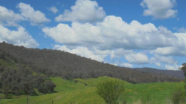
The views up top are really nice though. You can look out over all that bright green pasture mixed with pale swaths of eucalypts and dark patches of pine plantation. Shimmering blue dams are full and appear to gaze upward like wide open eyes. Light wisps of yellow paint distant hillsides – it’s capeweed – an exotic broadleaf weed that spreads easily. In the far distance, a hill with many granite outcrops glimmers as the sun reflects off the water seeping down the rock faces. To the southeast I can see the big hills I’ll be riding by later today. It is really gorgeous up here – and worth all that grunting and muscle-building. And if you ever find yourself at the intersection of the Stonehaven Road and Clifton Ring Road… there are plenty of places just off the road to whack up a tent.


I take off down the eastern side of the ring road. I am in for a treat. The gravel is pretty good and the downhills are mixed with just enough flat bits and gentle uphills to check my speed. There are great views off to the distant mountains and rolling hills the whole way. There is some pine plantation to give me scents of ‘home’. The road winds down and along a creek, through some trees, past some farmhouses and along one dodgy section where all the old BMX bike skills come in handy as I ride thin lines of high ground and weave through potholes, washouts and long dents of erosion. Considering all the rain we’ve had over five months, all the gravel I ride today is actually in really good shape for all that moisture.
Eventually we get spit out at the Westby Road – mostly just a 1.5 lane road of old pockmarked pavement. We ride beneath that hill of shimmering rock outcrops and out into more open pasture. There’s a creek in the distance that meanders across this basin.
We get out to the freeway and luck is on my side. Even though we now have to ride into the wind that’s been helping us, the road has been redone since Google Streetview came through. Streetview showed a very narrow and rough-looking chipseal for the two kilometres I need to be on there. But there is concrete now and it’s pretty wide. The bridge even has a semblance of a shoulder – enough that I won’t have to be in the traffic lane at least. Traffic is pretty light, too. Everyone, including the trucks, move out of the lane completely, or at least a little bit out of the lane, too. Thanks! When the new-ish concrete ends, brand new asphalt leads me down to the Four-mile Lane turnoff. What I was thinking was going to be a stressful couple kilometres was just fine!

The wind pushes us up Four-mile Lane. We ride up through open, hilly paddocks with some views to the tree-covered foothills in the distance. Up and up we go. We finally meet up with the creek and get some nice riding through remnant grassy box woodland. The creek crashes and gurgles through narrow points and wider meanders. There’s pretty much no traffic and no people – just cows, grass, some trees and rolling hills. We eventually lose our pavement as we turn up another creek valley that narrows quickly.
Again today, the cows look up and then start running toward me. I lead whole herds of cattle down the road until their paddock ends. I know they are hoping I’ve got supplemental hay to give them, but the human disappoints them today. They all bunch up in the corner at the end of the paddock and moo at me as I continue on. I have a theory about this cow chasing business: you can tell how farmers treat their livestock by whether they follow you or run away. The ones that come up to the fence or follow you for a kilometre down the road get a lot of human interaction and have kind owners. The cattle that run away… the owners are not as kind.
So up we go on the gravel in a narrow valley. There are some pine plantations that reach down on gentler hills and native bush reaching down steeper slopes to the creek below. Once we reach the head of the valley, we gain pavement as the climbing gets pretty steep. It’s definitely over 6 percent – it is likely pushing 8 percent. I grunt it out. Building muscle. One freakin’ fibre at a time. The native forest closes in and the road twists up out of that valley. It is gorgeous, but oh my goodness, do I ever need to get back in good shape!
We finally crest the hill and not too far down we get back to gravel. But it’s good gravel with fine crushed rocks and we can pick up speed without too much fear. We roll on down out of the bush and get great views to the distant mountains. I stop to take some video of the high rolling hills of pasture and plantation – but the camera just doesn’t really show the scale.

Down, down we go through bright green grass and bright blue sky. We finally reach a creek and have a short steep grunt up to the t-junction. Now we have a couple miles of uphill into the wind as we curve along a winding ridge up to the top of this valley. I rode this the other way last December, so I know I’m in for a climb. But once again, there are really nice views at the crest before we fly down into the Lankeys Creek valley.

I rode this road last December from Holbrook to the road we just came from. It was super-busy then being the beginning of Christmas holidays. This road also has lots of logging trucks, and now that they’ve widened and flattened Yarara Gap, it is b-double rated. That means there will be a lot more truck traffic on weekdays from now on. Luckily, today there isn’t much traffic at all. Which is good – because the road surface is really shit. You are good if you ride within 1.5 metres of the centre line on either side, but any closer to the edge and it is a rough mix of many years of patches, crumbling edges and chipseal heaped on holes and then gouged out again.
It’s a shame that this road has such a crap surface and such potential for truck traffic because it is beautiful. You follow the creek downstream and can watch it coursing through a rocky streambed below. Today it is extra gorgeous with all the extra flow creating rapids, cascades and small waterfalls. The hills close in and bush or pine come right down to the road or down to bright green paddocks that line the stream. There is a spot to camp along here – at the trailhead for the Hume and Hovell Track. It’s right on the stream and has a shelter and picnic table – the only drawback being that you will have to pick your bike up and climb over a fence stile to get to the camping spot. Looks like it would be nice though.


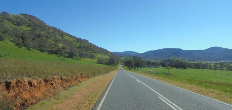
We meet up with the Jingellic Road – it’s in good condition and has a shoulder most of the way into town. You don’t take shoulders for granted whatsoever in Oz. I’ve ridden this road each way – so I know what I’m in for. If it’s your first time heading down to Jingellic, there is one steep hill that could catch you by surprise just before you get into town. After a downhill run, it’s a reality check for sure.

The general store is closed – it’s after 2pm – so I head down to the pub to get a Coke. $3.50 a can is pretty steep, but it hits the spot. We’ve been climbing and sweating a whole bunch today. The pub is busy even though the lunch rush is over. It’s an old pub but it’s got a really nice shady area out the back with picnic tables and a big, airy dining area inside. If you want traditional pub ambience – the bar area still has that. You can also camp below the pub in the recreation reserve and then pay a few bucks to the pub for a shower. The rec reserve is all muddy and puddly today since the river was flooding higher last week. Today the floods are just at minor level, but the river is still flowing high and fast in the distance.
On my way back to the main road, I come up to two couples with bikes, a car and a campervan. They are from Sydney and are taking turns riding and/or driving. They aren’t overly friendly, actually, but I tell them that they are in for a treat since we rarely see the dam fill and rarely have so much lush green around. One couple takes off about 10 minutes before me (I use the bathroom, re-sunscreen and fill water bottles for today and tonight) but I catch them at Mt Alfred Gap. The support vehicles leapfrog me until I get close to my campsite. Too bad not all cyclists are very friendly. If it had been me, I would have offered to drop gear or water ahead for a loaded touring cyclist or at least offered them something from my esky/fridge!


The Murray River Road is still my favourite road in the Albury area. It’s a lot more popular these days than it used to be, but it’s still a delight. It’s generally got good pavement and is scenic the whole way. It undulates up and down through forest and pasture edges – with the river and the bush-covered hills always in view and close by. There’s not much traffic this afternoon, so it’s good fun! The only negative is riding into that wind that helped us most of today.


I finally roll into the Kurrajongs campsite and am happy to see that no one is camping here tonight. When there are people in the campground, I usually just carry the bike up into the bush somewhere. But it’s all mine tonight. The creek is flowing, the birds are calling and the sun is getting low. I always think of this as a dry site – because most of the time it is. But today I can go down and wash off all the road grime and get cleaned up a bit – what a treat!
I am exhausted! 77 miles. 3500 feet of climbing – most of that on gravel. Maybe that was a little over-ambitious for the first loaded ride of spring. But maybe not. I am absolutely done – but in a good way. After some salmon and crackers for dinner, my legs feel alright and the guys and I go clambering up a hill to find some new cascades and rock outcrops set among the trees and many flowering herbs and shrubs.


Some people say that there really isn’t such a thing as introverts and extroverts. I figure they must sit somewhere in the middle of the scale. For those of us that hang off the end as outliers on the scale, I can assure you that everything they say about introverts is true for me. In a big way. I don’t just like quiet and solitude. I NEED it. I need silence like flowers need bees and sun. I need to be alone. I am rarely ever lonely when I’m alone. The only time I ever feel lonely is when I’m around other people. Oh yes, I need this – just me, the bush, the sky, the birds, the quiet. It fills me whole. There has been a ton of crap and frustration this past winter and spring – but I can’t help but think it wouldn’t have felt quite so crappy if I could have been doing overnight rides in that time. Oh yes, I need this and have missed this, and I’m so grateful I’ve got the chance to start getting out again.