
Taylor Park Reservoir to Buena Vista: Celebrating our highest pass with a dip in a sub-alpine lake
Tuesday June 22, 2010, 36 miles (58 km) – Total so far: 1,904 miles (3,064 km)
I make Jen get up obscenely early to tackle Cottonwood Pass. I’m pretty obsessive about these early starts now. I really like to get in the miles without the wind and traffic. So the sun isn’t over the horizon yet and the temperature hasn’t quite climbed above freezing when we set out. Now that we’re not 20-years-old anymore, Jen has some troubles with circulation and losing feeling in her extremities. I give her my good gloves since I know I’ll only need my cotton ones over my cycling ones, and off we go the 14 miles to the pass.

The western side of Cottonwood Pass is a gravel road and we were unable to get any definitive answers on its condition when we set out from Gunnison. The guy at the general store in Taylor Park yesterday said it might be a little muddy but it was definitely open and snow-free. So it’s nice to see that the lower portion is in good condition. Supposedly they spray the road with magnesium chloride which keeps the dirt packed and solid. We find good conditions the whole way up, but it is rough enough that it wouldn’t be much fun to come down at any significant speed. Riding up at 5-7 mph though is fine.
I’m trying to go slow for Jen but I’m slowly pulling ahead. I can’t go much slower or I start to wobble. So I keep going, thinking I’ll wait for her up ahead. The grade is pretty gentle and my asthma is not any worse than normal so I pedal at a decent pace to get warmed up; I’m actually hitting 9 mph at times. I wait for Jen at an old stagecoach stop from the mining days, but my own extremities are pretty numb and once I start to shiver, I decide I better keep moving. Jen’s not in sight but I know she can’t be too far behind and if she had any trouble she could flag down a vehicle. It’s quiet this morning but there are a few tradie trucks passing by every 10-15 minutes.


All of the climbing so far has been down in the trees in a section of forest that has just been pummelled with logging and the other multiple uses of the US Forest Service. But the climbing feels good until I reach a section with a steeper grade that lasts for a half a mile or so. That wakes me up! Not long after this I get into sections where the sun glare is so bad I can’t really see much but the road right in front of me. So I really keep my ear out and my eye on my mirror when I’m in the eastbound sections since I know there’s no way a car could see me.

Finally, I start to get above the trees. There’s a gorgeous section as you are emerging from the trees where the road switchbacks on itself many times (about 12). The grade is still quite rideable though (in the 5-7% range), so it’s good fun. I can’t quite tell where the top of the pass is from below, but I’m feeling strong this morning so I don’t really care. I’m just taking in the gorgeous scenery.

Just after I pass the parking lot for a lookout I think I can see Mom’s CRV coming up below. I can see the top of the pass now, too, so I sprint for it, wanting to beat Mom to the Pass. It’s not that easy to sprint at 12,000 feet, but I’m doing a commendable job, only to find out once I beat the SUV to the top by about 30 seconds that it’s not Mom after all. In this section, I’m able to see Jen down below. Her bright yellow jacket makes her easy to spot. She’s only about 7-10 minutes behind me. Mom is only about 5 minutes behind. Once Jen gets on the final straight I ride down and then head back up with her so Mom can get some shots of us riding together.


We use the Delorme maps to figure out a hike for the afternoon and arrange to meet Mom about a third of the way down the east side of the pass at the Denny Creek trailhead. Then Jen and I take off down the east side. Whee! At some point, Jen hits 45 mph, I hit 42 mph – but she is heaps faster going downhill than me. Just after I get through the switchbacks I realize I haven’t snapped the buckle on my helmet and figure I better stop and do so, because if I ever needed a helmet, this would be one of those times.


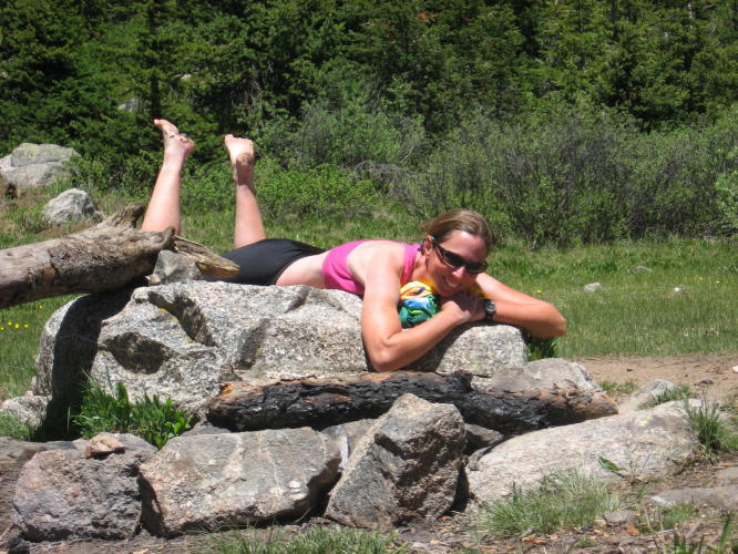
Jen waits on me up ahead (unlike me who didn’t wait for her this morning!) and then we resume the downhill run. There’s a steep 10% grade on a straight bit, but we don’t get to fully enjoy this as we’re looking for our trailhead. We find it not far ahead, lock our bikes up to the trailhead sign and then head off with Mom, who arrives shortly after us, up to Hartenstein Lake. This is a really popular trailhead because it’s the start for one of the fourteeners, but we don’t see many people out on the trail. It’s quite steep for several miles and we have to go slow for my Mom – whose asthma is significantly worse than mine. Unfortunately, the pine trees are one of her triggers. But it’s a gorgeous hike and we have beautiful weather to accompany it. Jen and I head in the lake for a bit of a polar bear dip – chilly on submersion, but man, oh man, does it feel so good when you come out and soak up the sun! We celebrate our highest pass of the trip and the summer solstice the day before.


Back on the bikes, Jen flies down the hill in front of me. She quickly loses me. I am so much slower than Jen that I do not have to brake at all in the lower portions of the descent – though there is one corner that I do hit too wide and should have braked on. Jen, on the other hand, braked throughout the trip down and was still way out in front. On the gentle downhill into Buena Vista out in the valley I have to constantly pedal to keep up with Jen while she can coast for bits at a time and still maintain 20 mph. The difference in our rides was really evident today!
Ave speed: 11.6 mph (7.6 up the pass) Max speed: 42 mph
Elevation start: 9400 ft. Elevation end: 7965
Cottonwood Pass: 12,126 ft. Ave grade: 5.4% Max grade: 8%