

21-27 January 2023
209 kms
Total Part 2 kms: 731
Total Trip kms: 3979
21 January 2023 – Nowa Nowa – Gunaikurnai Country – 5 kms
Ahh, to sleep in and let the sun hit the tent, to lie in my sleeping bag on soft grass and let the day’s warmth wake me instead of the alarm. Rest days align with my innate preference to wake up at 8.30am and start the day slowly. Ask anyone that knows me and they will tell you I am not a morning person. Don’t try to have an intelligent conversation with me before 8am and don’t expect me to want to eat before 10am.
I do like the early mornings on the bike, though, and I will drag myself out of the sleeping bag to enjoy the quiet of a pre-dawn start. I do love watching the sun rise while listening to the first beats of the day’s diurnal rhythm. I also really enjoy putting down the kays while there is little wind, heat and traffic. It really is a special time of day to be on the bike when the shadows are still long.
But I do enjoy a rest day and a long sleep-in, particularly after some big days (or when I’m trying to let my body recover from a virus). Today is a lazy day. I ride down to the river and watch the fish flop. I can’t imagine it would be difficult to hook one here given the amount I can see swimming around or flopping about. I eat some food and try to get a hold of my brother unsuccessfully for a catch-up. I check out the other caravan park which has a cafe to see if they stock orange juice. Nup, there is no OJ in Nowa Nowa.
I chat with the caravan park owner. He bought the place in 2017 and has fixed it up in a retro style. It’s a small place, kids aren’t really welcome, and he sorta vets who he lets stay. There are some older cabins, a new tiny home and some retro tear drop campers you can hire. It’s not cheap to stay here, but it is quiet and there is a good camp kitchen and fridge. I cook up rainbow veggie stir fries while I’m here and get down the nutrients I’ve been missing.


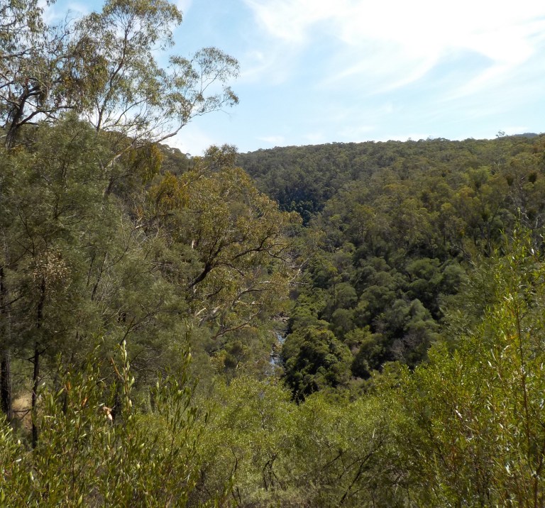
Later in the day I go do the local walks up to a lookout of the gorge and along the tidal river and through the forest. The sun comes and goes between clouds. The temperature is not too hot and the humidity is high. It doesn’t really feel like summer here, rather it’s like some odd season that you might call late spring if forced to decide. We’re quite close to the coast, and the vegetation is all on sandy soils by a tidal river. So it’s different to home and I enjoy looking at the leaves and bark of the trees I don’t really know.


And in a small world sort of thing… when I’m at the other caravan park looking for OJ, I run into a couple that I chatted to back in October on the cave tour at Naracoorte! They actually recognise me (all the old Boomers look alike to me!) and we have a nice chat about where we’ve been since those miserable days in spring.
22 January 2023 – Nowa Nowa – Gunaikurnai Country – 21 kms
In the early morning, before the few hours of headache and fatigue in the arvo, I head out of town uphill on the road to Buchan. I rode this in 2017, but today we only head out a few kays before we turn off and head up toward the lookout. We ride through open forest that’s had a mix of light and heavy 19/20 burn. The gravel is pretty good, but then it gets too steep to ride. I hide the bike in a bush and then set off on foot. It’s pretty steep even when walking, so it was the right decision to ditch the bike.
I hike up and up. The one lingering covid issue that’s a bit concerning is that I’ve got pretty bad vertigo when lying down and in the mornings. I had pretty bad vertigo for about a week after a bad case of the flu in 2012, so I wonder if this is a similar thing. It does make me very woozy when getting out of/in the tent, when rolling over in ‘bed’ and when bending over to pull down and pack up the tent. I also get random bits of it when upright if I turn my head too fast. Let’s hope it goes away soon!
The fire tower at the lookout burnt down in the fires. And there is no view, really. Just very fuzzy epicormic regrowth on the trees that obscures the view. Well, that was really not worth my time and effort. I’ve struck out on so many lookout views since October I’ve lost count!
So we slip and slide and sorta ski our way back down the hill to the bike. Then we get back on the bike and fly back down the hill toward the main road at speeds that I would not do if I thought a car might come along the road.
I stop off at the mountain bike park to go for a spin. The trails here are all pretty mellow, and it’s considered a ‘beginner’s park’. But I’m all for that. The trails wind through open forest that’s been logged in the last 20 years. The trails were built in conjunction with the gov dept in charge of state forests.

The climbing trail is about 5 kms long. It seems to take forever because it climbs at an incredibly gentle pace. It’s actually a bit boring!

The first downhill run I do is fun, but could do with some maintenance. It’s interesting that they’ve built berms out of pea gravel instead of dirt. They feel more slippery than dirt. Of course, I bring up some of that vertigo when I take a turn really tight and my head tilts with the bike. Woo-hoo, that is a very disconcerting feeling that adds to the challenge!

For my second run, I just ride the gravel road back to the top. It’s shorter than that frustrating climbing trail but is a fair bit steeper. I’ve got the fitness to do it though, and based on this climb and the ride up the road to the lookout this morning, I can say that covid has done nothing to my lungs.

The second downhill run is a bit more challenging and fun than the first, but both trails have such tall grass growing that it can be hard to tell where the trail goes at times which means you can’t rip right into it as fast as you’d like. All those grasses brushing my arms and legs make me very itchy, too.
I spend the afternoon just lazing in the shade, bucket washing my clothes and letting the sun recharge my camera, phone and powerbank.

23 January 2023 – Nowa Nowa – Gunaikurnai Country – 0 kms
I take the early bus down to Lakes Entrance again. This is a non-reserved service so I don’t have to talk my way on. We’re going to go down and do the tourist thing in Lakes Entrance today. Originally I had planned on riding there, having a look around, gathering supplies and then camping in the state forest on my way back toward Bruthen on the Gippsland Lakes Discovery Trail. This trail follows an old tram line through the forest before it joins the main rail trail between Nowa Nowa and Bruthen. But the tyre problems and the long stay in Nowa Nowa mean I’m going to skip that and just head down to have a look around via the bus.
Lakes Entrance sits between two arms of the Gippsland Lakes near the permanent entry from the ocean built in 1889. The Gippsland Lakes are actually a series of coastal lagoons separated from the ocean by long, sandy barriers. It’s the largest system of inland lakes in the Southern Hemisphere. 90 Mile Beach is a particularly long stretch of beach and sand dune that separates the lagoons from the sea. There are five main river systems that drain a catchment of more than 20,000 square kilometres which feed into the Lakes. The lakes are quite shallow, the largest lake being only 4 metres deep. The deepest bit is only 15 metres.
Before the permanent entry was constructed, the lakes only entered the sea through intermittent and changing blow-outs in the dunes. Apparently, you can see some of these if you hike 90-mile beach.
You can read more here:
https://vro.agriculture.vic.gov.au/dpi/vro/egregn.nsf/pages/eg_geomorphology_gipps_lakes
It is a water-lovers delight. Fishing, boating, water skiing, kayaking, paddleboarding, surfing and beach activities are all possible, and there are quite a few boat hire options in town. You can purchase fresh seafood from the fishing fleet and there are numerous fish and chip shops that use the local catch (at least in season).
You can see some aerial views here with good shots of the town around the 45 second mark:
So Lakes Entrance is a fishing and tourist town with a permanent population of 5,000 people and a zillion caravan parks and small motels. It only has one large resort-type hotel, and there are still many 1950s and 1960s cottages remaining in town. It seems much of the housing growth has extended into the hills and to the east of town. There is knock-down redevelopment occurring, but the town still feels quite low key unlike the holiday towns closer to Melbourne and along the Great Ocean Road west of Melbourne.

The main shopping strip runs along Cunningham Arm which is the lagoon between town and the barrier sand dune. The shops are mainly one story and older with a couple newer shopping centres featuring Kmart and Woolies in the centre of town. Another Lakes’ arm runs behind town where there are more boat hire opportunities.
This early morning is a bit overcast and cool, but the wind has calmed down since we came down for the tyre the other day, and that makes things much more pleasant. We walk along the boardwalk built along Cunningham Arm. We watch the fishermen detangling nets and washing out plastic tubs as the sea gulls gather round and cry out at each other when one intrudes another’s territory.


There are locals decked out in jumpers walking their dogs or going for a morning run. We head over to the main beach on the long pedestrian bridge over Cunningham Arm. The waves are low this morning and it just blows my mind how little separates the vast Tasman Sea from the lakes themselves. A pod of five dolphins elegantly carve half arcs through the water as they pop in and out of the waves.


We then hike up Jemmys Point, where the main highway climbs around the protrusion in a steep series of curves. The footpath is narrow and fenced from the main road and has a series of lookouts. I get stuck behind an old set of Boomer guys who are oblivious to anyone around them. Hilariously, they are talking about how much they hate smartphones, how bad/good their stocks are doing and whether they should purchase additional investment properties. It is so stereotypical of that generation that you couldn’t have written a more cliched script!
I finally get around them and head up to the Lions Lookout. There is a maritime beacon here (i.e modern-day lighthouse) with a fenced deck near the top. It would have great views. But it is locked and not open to the public. And the lookout itself has views obscured by vegetation. I strike out again! (If you are ever here, don’t bother with the Lions Lookout – the best views are from the footpath).


I then go back down to town and give the guys a float near a boat launch and fish cleaning station. There is a constant stream of boats going by, so the guys get to bob around quite a bit on the waves, ever nervous of the nearby sea gulls!
We walk along the other arm and enjoy looking at all the little fishing boats you can hire and people trying to figure them out as they pull away from the jetty. There’s not a heap of people around at the moment. It’s the calm before the storm. Australia Day is this weekend, and I expect it will be nuts then. That’s the last long weekend until March and the end of summer school holidays. Yippeeee!! The kiddies and camping crowd will diminish next week and I’ll start to have more places to myself.

I hang around at the bus stop chatting to the Nowa Nowa town drunk while we wait for the bus which is an hour late. He was on the bus the other day, too. He lost his licence, and almost his life, a couple years ago in a car accident. He had a lot of internal injuries. Now he takes the bus down to Lakes Entrance most days to buy his slab of beer for the night. He takes the morning bus down and then goes to the pub to drink and play pool until the mid-day bus returns to Nowa Nowa. He gets through three beers and two cigarettes in the time it takes for the bus to arrive. He thinks covid is a scam and can’t understand how people could be so stupid to vote the Andrews Government back in. I laugh inside – he’s the sort of person that most benefits from less conservative governments, so he shouldn’t be bashing them!
After I’ve inhaled way more second-hand smoke than anyone should ever have to (you are technically not allowed to smoke at bus stops), the bus finally arrives. I ask if I can go to Nowa Nowa, the driver says, “Yep, just hop on” and won’t take my fare. It turns out this is actually the bus that eventually goes to Canberra. Nowa Nowa isn’t one of his stops, but since he goes right by the stop at the General Store, he takes us anyway. The actual Nowa Nowa bus isn’t too far behind because I see it passing by five minutes later as I’m walking back to the caravan park to get all ready to ride tomorrow. You couldn’t get a greater difference than ‘yeah, just hop on my reserved service to Canberra for free’ to the guy the other day who didn’t want to let me board.
24 January 2023 – Nowa Nowa to Bairnsdale – Gurnaikurnai Country – 68 kms
Okay, so let’s try this again. The light is still low and the air is still crisp when we shove off at 7am. We’re a month past solstice and sunrise isn’t until 6.15am now.
We ride past the Stoney Creek Trestle Bridge and the turn-off to Costicks Weir again. The rail trail is a long, gentle pull on a sandy surface all the way to Colquhoun. Back in 2017, the surface was rough and rocky. They’ve resurfaced it since then and it’s now sandy instead. It’s a bit gluggy here and there but better than before.
You don’t really feel like you are IN the forest. It’s more like you are AMONGST it as you follow a wide gas pipeline easement with a backdrop of thinned or clearcut forest 20 metres away.
Just as I start the good downhill into Bruthen, I pass a heavily laden touring cyclist in his 20s or 30s who is riding with an unloaded guy. We wave, I don’t bother to stop to chat. It is not my custom to talk to people on established routes or trails – if I see a touring cyclist on some random road, I will generally stop to chat though.
We enter into some densely-shaded forest bits and a steep drop to the creek off to the left. Ah, this is more scenic! Views filter by fast as we look through the trees over to cleared, tall and rolling hills. Then, as you pop out of the forest, there are long views over the wide and green Tambo River valley to the singed forested slopes on the opposite side.


At the bottom of the hill is a sideways M-shaped gate. These are terrible for getting a loaded bike through as the multiple 180 degree turns are too tight to maneuver. So I get to the gate and go to dismount to wedge my bike through. But a pannier gets caught on the gate and my forward momentum causes me to stumble. The bike moves out of the way as I crash down hard on my left knee, shoulder and chin. The gravel here has baseball-sized, chunky bits, and one of them gashes open my chin. Another rock collides with the front of my kneecap where a huge lump and bruise almost immediately appear. My shoulder will bruise and there will be an abrasion there under my shirt. I also take a tiny chunk out of my cheek. It’s a heavy fall and my head bounces back as I recoil from the ground.

I stand there for a few moments regathering myself. Imagine me shaking my head to this sound:
I hope this might have knocked the ear crystals around and cured my vertigo, but it does not. So we take off for the next few kms into Bruthen with throbbing knee and blood-dripping chin. It really hurts and my chin makes me look like I’ve been in a fight. I notice I’ve also skinned up a knuckle on my left hand. I can’t remember the last time I’ve come off the bike and drawn blood. (Luckily this is the only accident on the whole Oct-April tour.)
My knee slowly comes good with movement as we trace the edge of the Tambo Valley before the rail trail becomes forested and well-shaded. Then it’s long climbs and descents over and over somewhere in the rolling landscape. We are far away from the main roads, so it really feels like you could be anywhere in that long, linear corridor of trees.


They have resealed the first 6 kms out of Bairnsdale that were so bad back in 2017, but it’s still a long, flat boring section. To get into Bairnsdale proper, you have to ride the footpath on the main road bridge over the Mitchell River. I have to stop for two pedestrians and two mobility scooters who can just squeeze by.
Bairnsdale is a large service town with a main street that is a divided highway. The middle divide is grassy, manicured parkland with one and two-story shops for its length. The side roads leading away from the main road are also lined with shops and there are a couple blocks of restaurants and retail behind the main street. It isn’t a fancy town – there was never gold here. To me it feels a bit like Warrnambool.
I head to the bike shop and book the bike in for a service in a week’s time. They’ll replace chain and brake pads for me and check that the rear cluster is still okay. Then I go about getting a week’s worth of food, a new tarp, replacement flip flops and other bits and pieces.

There used to be two caravan parks in Bairnsdale, but one is no longer open and you can’t camp at the Showgrounds. The caravan park that is open sucks. I’ve stayed here before. It is super noisy being on the main highway. The town bike path goes through the back of the park and the tent area has no defined sites, has very little shade and is open to the footpath on the main road. Anyone can walk through the park, so there is no security for your stuff should you want to go to the toilet block.
So I book a powered site, just so I know I can get some shade, and so I can fully charge all my gear before heading bush again. The difference is only $4 from the powered site. Last time I was here, the owners were kind though, and they even gave me some of their laundry detergent to use. But the NRMA has since purchased the park, and the lady at the desk is not particularly friendly. She gives me a caravan site with no grass or shade that is near the sites booked out by a large rowing club. The kid rowers are staying in all the cabins, but they have all of the staff cars and buses and a dining tent set up on the sites.
I ride down to find my site is right next to the walking path and bbq and currently has a vehicle parked on it. I go back to the office to see if they have another site. Not really, she says. I know that there is no one on the small, shaded, grassed sites at the front of the park (which is what I thought I’d get when I booked). She finally decides to offer me one of those, prefacing it with, “if you don’t mind noise, I can give you one of these sites”. I tell her that is just fine. Really, the entire park is noisy, so a 100 feet this way or that makes no difference.


A guy on a bike on the footpath pulls up and talks to me through the fence. He retired here because of the good bike infrastructure (where’s that? I haven’t seen it) and access to forest and sea. He’s American by accent but we never get into that. He likes to tour and rides his bike all over town. He’s tried to ride to Dargo before, but the distance became too great. He loves riding in Japan and tells me he sees a fair number of bike tourists here because of the rail trail. When I respond to his question of where I’m heading he responds, “Ohhhhh… that’s really steep.” I got the same reaction from the guys at the bike shop earlier today. They said I had to be really keen to want to ride those roads. I’ve come to the conclusion, however, that whenever someone says it is too hard or steep that it will actually be hard, but do-able and just the kind of ride I like to do!
25 January 2023 – Bairnsdale to Sandy Creek – Gunaikurnai Country – 58 kms
I plot a route that will take me on backroads and gravel roads to escape Bairnsdale. I remember the ride in from Lindenow (my direction today) being rather hairy in 2017, so I’d like to avoid that.
So I head out Forge Creek Road to the south before heading west and north. The only trouble is that Forge Creek Road appears to be the main commuter road between Bairnsdale and Paynesville. The main C-road is actually over to the east, but there is heaps of traffic on this non-alphabetted road. More traffic is going the other way to the north, but it is still tense and not fun since there is no shoulder and several hills to slow me down. Two semis overtake me, but luckily there’s a break in the oncoming traffic at that time. 95 percent of the drivers have no knowledge of the 1.5 metre overtaking rule nor do they pay any attention to the 80kph speed limit.
I finally get off that road and do some deep breathing exercises as I ride to calm my poor nervous system down. If I had to do this over again, I’d just take the A1 and ride in the dirt shoulder. It’d be quicker and probably safer as there was no dirt shoulder on this one to use.
I finally get over to a gravel road and relax, thinking I’ve finally made it to a proper backroad. But within minutes, I have to stop for a ute to pass. Minutes later I come across a lady walking two dogs. Then a few minutes after that I get passed by a ute, and then a big tractor.
I turn north on another gravel road and get overtaken by two more cars spaced just a minute or so apart. For the second car, I don’t bother pulling over. I just let them follow me the final 200 metres to the highway. FFS, I’m not stopping again!
Finally, the traffic lets up and I make my way toward the edge of Lindenow on rough, sandy and loose, corrugated gravel. There’s no good lines to follow. Blechh. I can’t wait to get back into the mountains.

The ranges get closer and we eventually drop down to the wide, intensively-farmed Mitchell River flats. This is a major growing area for leafy greens, broccoli and cauliflower. There are fields in every stage of growth.

On the other side of the river, we wind along and up and down the base of the hills until we hit the Old Weir Road turn-off. Our road appears to disappear into a cleft in the hills. And so we follow the road into the cleft where it immediately starts to climb an incised creek between the steep, cleared hills.
We pop out of this creek onto the hilltops and continue climbing. We go up and over another steep hill. A farmer follows behind slowly and then passes by at walking speed so I can maintain my momentum up the hill. I wave thanks and he waves back and gives a gentle ute hoot.
We then dive to a creek and enter state forest. We climb for a long time through some really flogged forest with pretty fresh clear cuts and then more open forest with larger trees that have been spared in the past. It’s steep in bits but never so steep we have to get off and push. We make out way up from 50 metres above sea level to 450.

We then get to a gorgeous, long downhill into a large basin. They haven’t logged in here recently, and there’s no recently singed trees, so it feels alive and vibrant and green. The convoluted ridges and many small tributaries flowing into the main creek make it feel as if we are descending into a labyrinth. The views are spectacular.


The road clings to the side of the hill as it curves, twists and plunges down and down. Yee-ha! What fun! What great views!
As I come cascading down the gravel in the final u-turn, I note there are a couple forestry trucks at the bottom. It’s three 20-something guys on a forest work crew that are pulling dead trees away from the upside of the bridge. This is meant to be my campsite for the night, but I’ll have to wait until 3.30pm when they leave to have the place to myself.
I find a spot in the creek in the shade where I can hang out for the afternoon. It’s pretty hot today, so legs in the water feel good. I’m out of the way of where the cables might land if the winch they are using on the trees gives way. I catch up my journal and watch the dragonflies dance over the turtle and frog floating the afternoon away.


After the workmen leave, I filter water upstream from the bridge and set up my camp near the road. The forest guys say they hardly ever see anyone on this road, so it shouldn’t be a problem. They think I’m a bit crazy for riding here. The main guy talking to me says he’s only ever seen one guy on a bike on these roads, and that guy was at the top of Baldhead Road. “I thought he must have been a bit nuts to want to ride up there, but you take the cake. He wasn’t carrying any bags.”
Well, I guess I would rather be nutty than boring, keen than complacent and healthy than sedentary. To each their own. I couldn’t imagine anything else I’d rather be doing!
The best news today: headache and fatigue never made an appearance. The vertigo is still there though.

26 January 2023 – Sandy Creek to Marthavale – Gunaikurnai Country – 35 kms
There is high cloud, but no sound except the trickling water in the creek. There is no wind. Even the trees are quiet and still. We have a steep 200 metre climb away from the creek to start, but then the grade backs off as we slowly climb to a ridge, ducking in and out of every drainage in that special way that squiggly line roads do.
The surface is decent and the views across the steep valley to rocky, cliff faces and dense forest are a breakfast for the eyes. We meet one vehicle – a guy driving so slow I’m sure he’s a Lindenow local who drunk too much last night at the Dargo pub and is slowly making his way home at 7am along twisty roads with very steep drop-offs. That’s the last vehicle I’ll see today.

The curves taking us above the creek are confusing in this maze of a watershed, and I certainly feel like I’m heading south instead of north when I get to the road intersection where I need to go straight to get onto the Morris Peak Road.

This road takes us up onto a ridge, ever-so-gently pulling us up and up. The view would be fantastic up here on a clear day! But I just don’t have the luck with getting views on this trip. Still, it’s a smiley-feeling in your soul to look out across three or four ridges of trees and feel deep in the forest. We can see the clearing down in the Tabberabbera area though, so we’re not too far from humans.


The super gentle climb takes us up and over 600 metres with only the last bits of the last kilometre feeling very steep. But by now, as we’ve risen in elevation and the clouds have closed in, we’re just riding in fog and increasing drizzle. It is cold and wet. There are no views now but the road in front of us and the nearby trees that have escaped logging.

Once past Morris Peak, the drizzle becomes worse and my clothes are damp. It’s probably about 13 degrees. Gravity pulls at the accumulated moisture in the tree leaves until the water succumbs and spats on my arms.
The road is now a rollercoaster of ups and downs where the road ahead disappears into the fog. I let the bike run on the descents to try to get as far up the next steep ascent as possible. There is still a lot of grunting and slow wobbling up on rocky surfaces at 5.2 kph. We’re gaining another 250 metres in elevation, so the gentle first half to Morris Peak is more than made up for as we climb to the Baldhead Road.
The last kilometre is particularly rocky, with loose slabby stuff eventually causing me to put a foot down. This, of course, means I have to push the bike up the final bits because it’s too steep to get started again.
There would be views up here, but not today. It’s cold, foggy and wet. Full-stop. I did have a bit of phone reception back on the ridge, and the forecast called for afternoon storms in the ranges. It doesn’t feel stormy, but I did do severe thunderstorms in fog in the Toombullups a couple years ago and that was not fun at all. Plus, it’s foggy enough and visibility low enough not to feel super safe, even though I’ll only see one car all day. Plus I’ve got no chance of views as the road will continue to ascend. So I think I need to drop off the ridge instead of continuing further. This will also allow me to get water.
So we ride a bit further up and then drop 200 metres in 4.5 kilometres to Marthavale Hut. Since Australia Day weekend is coming, I’m afraid that there will be a lot of people. I don’t like camping at huts at any time, let alone a long weekend, but I’m sure I’ll find a spot somewhere. The climb out tomorrow won’t be fun though!
The fires haven’t been down in the valley, so there are nice trees and a welcoming setting. The hoons have torn up a lot of the camping area, so DELWP have gone in and placed big boulders around to stop it from continuing.
Luckily, there is only one very bogan family camping down here. As I come roaring down the hill into the campsite, the two young kids look at me like I’ve just dropped out of a UFO. They race back to their campsite. I go up to say hello and ask if it’s okay to set up my tent a bit further down. They aren’t overly friendly but don’t care if I camp and tell me to use the hut if it gets too rainy.
There’s a picnic table and grassy area well away from them, so I set up down there. Then, I get my clothes dry and fix up some soup to help get warm again. Afterwards, I crawl in the tent and have a nap.

The family is not a problem. Their campfire smoke doesn’t come my way and they are not too noisy. I do hear the Dad come over with the 8-year-old and walk near the picnic table. I hear the guy pull back the plastic sheet I put over the bike frame to keep the frame bag and contents from getting any wetter. He then lets the plastic drop back. I’m sure they’ve had a discussion among themselves whether or not I was on an ebike, and he’s come over to resolve that argument. They did look rather surprised to see someone rock up on a bike.
The drizzle comes and goes and turns into a couple of rain showers in the evening. Sadly this means the guys don’t get a float in the Nicholson River, but it’s not so bad to be warm in the sleeping bag, lazing away the rest of the day in the tent. Beats the office anyday!
27 January 2023 – Marthavale to White Bridges – Gunaikurnai Country – 22 kms
The sky is still cloudy and the peaks are fogged in. But it doesn’t seem quite so bad as yesterday, so let’s go. The tent is still wet, but it has not rained overnight.
I’m away around 8am. My hope is that if I’ve got the timing right, that by the time I make it up to the views, the cloud will have moved off. It will take me 45 minutes or so to do that 4.5 km, 200 metre climb, I think.


So we slog our way up through pleasant open forest, slowly but steadily climbing. It’s actually not all that bad. It gives me hope when the sky lightens and the sun seem like it could be up there somewhere behind the cloud.
The peaks to the north are all still in heavy fog though. I tell myself maybe I can just take the bright spot with me as I go. This just makes the Crowded House song “Weather with You” get stuck in my head all day!
We finally get back to the Baldhead Road. Today we’ll climb up to 1200 metres. The road has a varying surface, from large embedded road base stones to wet, sandy stuff that rides soggy.

We slowly gain elevation and have views over to the fogged -in ridges where the fires have gone through. A couple of the Tambo Complex fires started around this area, so the burn is patchy. Some bits have burnt severely whereas other stuff hasn’t really burnt at all. It would be interesting to see from the air. But these fires eventually really took off and had some of the most explosive growth in the VIC fires. These fires eventually burnt all the way to Buchan.


The light spot in the sky follows me for awhile, but then we outrun it as we climb in elevation. Just when we think we are going to ride right into the fog, the road heads through a gap in the ridge and traverses the opposite side.
And over there, low and behold, there are patches of blue and the fog is lifting. We can see for a long distance. A bit of burnt area is close to the ridge we are on, but kays of recently unburnt forest many ridges deep appear. The views make these big climbs all worthwhile.


We swap back to the other side of the ridge again and into the fog, but it’s taken a cue from the west side and is now starting to lift.
We climb some more. There are steeper bits through here, but it’s all manageable without pushing. I’m not cold or wet and feel like I’ve found a groove.
It’s all mental, really. Can you be comfortable with grinding away in granny gear for a few hours on end? Are you patient enough to move along at 5-7 kph for half a day? Can you hold your focus on the road surface for hours on end – constantly surveying the rocks ahead and picking a line? The grade varies. The surface varies. But ‘slow’ is constant, and you have to be content with that.
Of course, as the day clears and we get close to the high point, the views disappear. They’ve done a heap of clearcuts and we’re hemmed in by regrowth acacias and ash for several kays. The amount of logging they’ve recently done here is pretty disgusting to me.
But, oh, it gets worse. As we reach the road intersection at the base of Mt Baldhead, there are brand new clearcuts, not yet done, over a huge area. There’s even more in the distance that stand out like ugly scars across the viewscape. This isn’t salvage logging – this is just extensive clearcuts all going to be pulped. (I read later that this is one of their current focal areas along with the area along the Timbarra Rd we saw a few days ago. The size of these coupes is just crazy huge).

The drop down to a creek over 3 kays is quite steep. That won’t be fun to come back up! Again, we are dropping down to a water source to camp that will set us up for a longer ride day after tomorrow. It’s supposed to be hot and windy down in the valleys tomorrow. So we’ll sit it out at 1150 metres where it should be cooler.
There is a good place to camp here, but the creek is more like a pond. We can get water from below the road, but it looks like it will be pretty interesting to get down there.

We spend the afternoon napping and looking at maps. I think as long as I take frequent rest days that we’ll outrun any chance of long covid (or post-viral fatigue syndrome) returning. I’ve felt fine fatigue-wise on all of these big climbing days. My lungs have been fine. The vertigo makes balance a little fun at times in the mornings, but it always goes away after I’ve been up for a bit.
But January is almost over! Where did it go? And what do we want to do with February?
What a mixture of camp sites from Resorts to sitting by the roadside. Although covid hung around for you it was good that you had the mornings “clear” so could get on with life before the crappy bit kicked in. Vertigo. I recall packing Sue off home when we were at Yamba – she was plagued by dizziness with that early morning getting up issue. It stayed all day though and no amount of shaking head, throwing herself around moved the crystals. When you wrote about your fall I thought “that should fix the vertigo” but unfortunately it didn’t. Anyway, another great month on the pedals.
The COVID was like the least worst cold I’ve ever had with only a couple days of sore throat. I’m not sure anyone else would have even noticed the arvo fatigue/headache. I’m just very,very aware of that sort of stuff now. Not sure if the vertigo was even from COVID, but I think it was. It was never too terrible like sue had. Interestingly, my recent 2nd COVID experience was much worse and had respiratory symptoms but no vertigo. Four weeks after symptoms began and I’ve only felt totally normal the past couple days. Weirdo.
This week in Jan was a great week on the road though – I felt like I was back in the groove!
Your description of riding the mountain bike trails made me feel bad about the death of my own mountain bike–the victim of severe rust caused by years of winter cycling. Then the story of your fall a couple days later, reminded me of a couple of my own crashes. I always got off pretty easy–no serious blood–but sometimes a very sore body for a couple days. I recently ran into a guy who got a broken arm riding on the very same trails I used to ride. At this time, I’m not sure if I’ll get a new mountain bike or not.
By the way, I really liked that scrap metal sculpture of a kangaroo.
Maybe you could get a used MTN bike and fix it up a bit, so it’s no big loss if you don’t enjoy it. My friend’s uncle who still competes in MTN biking at age 76 says after 65 (I know you’re not there yet!), you just have to ride for fun and forget what you used to be able to do. He likes it though because he’s very competitive with himself and the races make him ensure he keeps up his training. The day I had lunch with him last September, he’d just done a 50 mile road bike ride in the morning.
Thankfully my crash, actually I was already on foot, so I guess it was a fall, was hard but slow. And I really wasn’t sore afterward, maybe because I kept moving. I only dripped blood for a couple KMs before it scabbed over. I was too lazy to dig to the bottom of my front fork bag for the first aid kit.