

28 January – 3 February 2023
277 kms
Total Part 2 kms: 1008
Total Trip kms: 4256
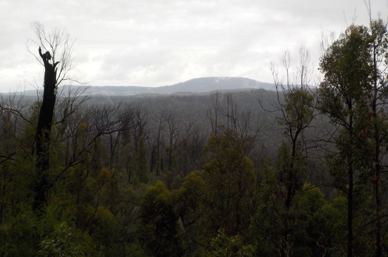
28 January 2023 – White Bridges – Gunaikurnai Country – 0 kms
I’m standing on the road surveying the situation. I walk to the upside of the road and peer down into the vegetation. I can’t really see the creek at all down there. The drop-off from the road is pretty much straight down. So I go over to the downside of the road. I can see the water flowing out of the culvert before it spreads into a wider course through muddy banks.
We’re going to have to get water from that side. Now, how to get down there. The grass is about boob-height and you can’t really see the ground itself. But it looks like the embankment they’ve built for the road has large rocks down by the culvert itself that I could stand on. I’m sure at some point there was a bridge here, hence the name White Bridges, but it seems that in more recent times they’ve funneled the creek through a culvert and then just built up the road on an embankment so there was not a steep drop to the creek. The area is state forest, but it really just has an industrial plantation feel given the extensive logging that’s gone on here. Nothing seems natural here at all, so who knows how the creek used to run.
So I gather my water bottles, my cooking pot and filter. I put it all in my little backpack and look for the easiest way down through all that grass. I have no choice. I have to get water. I step down off the road and pound my feet, warning any snakes that I’m coming, so please move off and don’t end my life with a bite here today.
The ground is uneven and steep and we drop more quickly than anticipated. Whoa – pull back that momentum before we go headlong down the hill in something reminiscent of a nursery rhyme! But we’re able to parallel back toward the culvert below the road. I smash the grass down as I go so it will be easier to come back for refills tonight in preparation for riding tomorrow.
I clamber down onto the jagged boulders below the culvert. They point in all different directions and balance is a bit hard. The vertigo still hanging about doesn’t help. But I find a way to seat myself on one rock, brace my body with my foot against another rock and then lean way in toward the culvert so that I can scoop up water with my cooking pot. It is a very weird angle, and when fully extended, I feel like I could almost fall into the water. At least it is very warm today, so that would not be terrible if it occurred.
I eventually get all five litres filtered and only get one leech stuck to my thumb. Luckily, I can pry it off before it becomes a bloody mess. It’s 20 minutes of doing sit-ups to reach the water, but I’m thankful there is a water source at all at the top of a catchment at this time of year. This water runs into the Wentworth River. We’ve dropped down off the ridge on the opposite side of the Nicholson River catchment that we’ll circle around over a few days.
And that’s the only physical work we do today. It does get quite warm, and there is a strong northwesterly wind. I imagine it would be quite hot at lower elevations.

Australia Day was Thursday, so I expect there to be more traffic out and about today and tomorrow as the last weekend of summer before the kids go back to school. I guess Australia Day is like Oz’s version of the 4th of July, only we have no independence to celebrate. The Queen is still our Head of State. Australia Day has become very controversial in recent years, as it celebrates when Captain Cook sailed into Sydney Harbour. So of course, many First Nations peoples find this very offensive and call it Invasion Day. It was the beginning of their culture and way of life being trashed. There are calls to change the date, and some local government areas no longer hold citizenship ceremonies or other celebrations on that day like they did in the past.
At the moment, though, it’s still a conversation, and many conservative white people are very against the change. But at least the conversation is starting to be had. My personal opinion is that it should be decided by the First Nations peoples. They get to decide, as a collective group, whether the date should be changed, and what date to change it to.
I don’t understand why people are so opposed to changing it – Australia Day has only been a thing and a public holiday since 1988. It’s not like the 4th of July in America that has significant origins (a revolution!) and goes back to 1776! (Captain Cook didn’t even make it to Sydney Harbour until 1788).
I guess the best way to get rid of that date would be to just become a republic already. We pretty much function like one anyway, and who the heck wants to be governed by King Charles once the well-loved Queen dies? My only hope would be that we become a republic some time between August and November. All of our public holidays are loaded into the front half of the calendar year, and we are sorely missing any days off between mid-June and November!
Midnight Oil recently released an album with significant First Nations collaboration in support of the Uluru Statement from the Heart. There are a couple relevant songs linked below. The second one brought tears to my eyes the first time I heard it, because I’m one of those bleeding heart types apparently.
You can’t think about the future still running from the past
Tall tales lie in history and flames burn through the memories
There’s a country that is aching for a way to call its own
You can feel the mansions shaking as the first real seed is sown
Now you can’t talk about the future if you’re running from the past
It’s a terror in Australia, jails and guns and failure
Can you see the ships a coming, stately through the heads
And arched out over the white sails is the merchant’s flag of red
Now Captain Cook spawns Captain Coke and beer flows over rum
In a twinkling of an eye my friend they spent your dollars very well
And those traditions they can’t sell sit silent in the sun
Where ignorance and wealth combine to crush the fruit upon the vine
It’s a terror in Australia
So I spend some time reflecting on this and the enormity of time – how many generations 60,000 years represent and how you could wipe all that out in less than 200 years. I think about how we’ve done the same with climate change and how the stain of our species will eventually show up in the fossil record. If you’ve never had the chance to see the KT boundary, then you should add that to your bucket list. When you see that mass extinction event that wrote off the dinosaurs as just a few centimetres of rock in the landscape, it gives you a much better idea of time. It illustrates what significance human actions have had on human history in a blink of an eye, but how that blink of an eye means so little in geological time when human concerns are so insignificant.
The road is much busier than yesterday when I saw no vehicles. Today, about 10 or 12 4WDs fly by, heading somewhere to camp for the weekend. I wonder if anyone was at work on Friday or the whole country took the day off to have a 4-day weekend. Three 4WDs stop and start to pull into this clearing before seeing my tent and then driving off.
One 4WD drives past, then backs up and pulls in. They get out and check the place out and look at the water source. It’s an overweight guy about my age, another man probably in his 30s and an overweight teenage kid. I’m sure they’d camp here if I wasn’t here, and I’m crossing my fingers they won’t decide to crowd in on me like those deer hunters back in the Strathbogies in December.
They come over to chat. They are in complete disbelief that I am travelling solo and am riding my bike around up here. They thought I had been dropped off by a 4WD that would be returning later. The fat guy keeps saying, “So you rode all the way up here?”, shaking his head. He asks where I came from, as Swifts Creek is only about 18 kms away. When I say I came from Bairnsdale via Morris Peak and Marthavale, he just keeps shaking his head. “That’s just crazy. Riding all the way up here. He shakes his head again and looks me up and down, trying to figure out how a skinny chick could do such a thing on her own. “You must be very fit to be able to do that.” I tell him I’m pretty fit at this point, but really, I’m just more determined than anything else.

No one else bothers me and I enjoy watching the different clouds moving over ahead of the front that will come to push the hot air out. I’ve had no phone reception the past coupla days, so I’ve got no idea of what’s coming when. That’s one of the things I love about this sort of riding – figuring out how to deal with basic needs like sourcing water and reading the weather and clouds to keep yourself safe. I love being back to basics and away from technology in ways that most people would find pretty extreme and unpleasant. I don’t find it that way at all. I’m confident in my camping and riding skills at this point and I’m absolutely loving being able to be out in the forest for a week or so at a time. It’ll be a sad day when age catches me and this sort of ride is not possible anymore.
29 January 2023 – White Bridges to Stantons Place – Gunaikurnai Country – 58 kms
It’s cloudy when I wake, but the breeze has kept the tent dry. It’s still warm. The front did not come through overnight.
The darkness of the clouds as we ride up the steep bits through the recently logged forest makes it feel particularly grim. I just can’t believe we’re cutting this down. 80 percent of the forests in Gippsland burnt in the 19/20 fires. Don’t you think you might not want to decimate the remaining 20 percent while everything is recovering?


We regain the ridge and then dive right back off of it as we descend to a gap. There are two creeks running over here, but I’m not too confident they’d have water at this time of year in a normal summer. But it could be an option.
We’re circumnavigating the rest of the Nicholson River catchment today – after coming up the west side of it the other day and dropping down to it when we camped at Marthavale. We’re back into very burnt bits – this fire had such explosive growth that many parts of the forest are well-seared while a few tiny bits were relatively untouched.
The good news is that the Roller I saw at the top of the road two days ago is gone, but all of this road that I ride today has been freshly graded and rolled. That means a good surface to tread today. There are some bits where they’ve put a layer of gravel on top that will ride very loose and marbly, but I’m more comfortable on that sort of surface now and can just let the bike ski itself through it. It gets your adrenalin levels up a bit, but in turn, you also get a nice, sweet dopamine hit, too. I know a lot of people self-medicate with alcohol, but really, if everyone knew what a bike could do for your head and heart, they’d toss away the bottle and I’d see heaps of riders on my travels instead of none.

We ride up and down the ridge, weaving in and out of the headwaters of each creek that feeds the Nicholson. There’s an initial fast downhill from the road high point to the gap, but then plenty of climbing for the next 7 or 8 kms. We ride through pockets of severely burnt bush with dead trees and full canopy scorch. There are other areas where the burn was moderate and the trees are all fuzzy with epicormic regrowth. Still other spots, mostly gullies on south-facing slopes, have only had a light burn.

After doing a PhD related to bushfire, and all of my conversations with firefighters then, I find all of this pretty fascinating. I also find it pretty horrifying given the extent and severity and the likelihood of fires like this becoming common with climate change. In some places, I’m certain I’m seeing the beginning of ecosystem collapse. A lot of the area I ride through today was burnt in the 2006/07 fires, and you can see the regrowth from that fire being burnt again. I think these sorts of views will be normal in the future. Victoria has had three major fires covering more than a million hectares each time in less than 20 years (2003, 2006/07, 2019/20). If we end up getting this sort of fire every 10 years or so going forward, then it seems likely we are already past the tipping point for these forests. It is so incredibly sobering.

I can see darker bits of sky to the west and northwest, and I can see rain across one of the valleys. The forecast for today, three days ago, was just for cloudy skies. But given what I can see right here and now from this ridgetop, I’m not too surprised when I feel a few big drops splatter down on me every now and again.
I put the guys in the panniers, thinking if I do that, it won’t rain. Hmmm… I wonder what part of the brain makes you think you can change weather systems by stowing your crew or putting on a raincoat (which I don’t do). We’ve all done it!

We eventually start to get more down than up and get good views where the fire has taken away the foliage. I marvel at the super-long Barmouth Spur that runs parallel to this ride for quite a long way. Up here it’s just a jumble of ridges and spurs in all directions with very steep drops to the creeks that run between them.


It starts to rain lightly, but it’s not too cold, so I just get damp. The bike gets covered with wet, sandy muck from that freshly graded surface.


At our turn-off (we’re on Engineers Road that runs to Bruthen), I stop to see if I can get some phone reception. Yes. But it’s properly raining now, so I keep my phone time short. I get the weather forecast and look at the radar. There’s a lot more and heavier rain to come from the northwest. If we hurry up, we might be able to drop back down to the Nicholson River that’s about 5 kms away and miss the heavier stuff.

So I take off down the Nicholson River Track and immediately have some climbs as we traverse up and down another ridge. Slow, slow! Hurry up, Em, there’s heavy rain coming! There’s fog on the peaks now, and the rain is about to set in for the day. Hurry up!
We get to the Store Creek Road, and I think we should have a nice drop off the ridge to the river. But, wait, there’s more. More steep climbs – including one steep enough that I have to get off and push. Hurry up, Em!

Then we finally get the downhill with the road cut into the side of the hill. The green shurbbery and brown tree bark flashes past as I keep my butt back and pulse the brakes. Yee-ha!

We know we are getting close when we start to see toilet paper bushes. Burn it or carry it out! You are not being helpful leaving it behind to point out to others where you’ve pooped.
We drop steeply down to the river. It’s gorgeous here. Upstream it flows slowly between large trees. The track crosses just upstream of where the river makes a wide bend cut into the outside bank. Large, sandy bars and flat cobblestone beaches line the inside of the bend. There’s a big, deep swimming hole just before the bend. It’s a really nice spot (no wonder there’s so much TP just up the 4WD track) and the fire hasn’t been down here.

I watch the rain start as it plops down into the water creating hundreds of rings on the surface in the slow-moving water upstream. The heavy rain is imminent, but I still take the time to take off my shoes to ford the river. I am not in the mood for wet feet for days. There is a definite path under the water to cross where the 4WDs have smooshed down the rocks, but they are still big enough that I would not be able to get over all of them without having to put a foot down.
So I just push the bike across. It’s easy enough on my bare virgin feet. It’s only shin-deep all the way across, and I just ensure I have my feet planted and comfy before the next push forward.
The hardest part is getting the bike over all of the big rocks placed at the bottom of the track on the west side. They’ve put the rock in where the river has undercut the concreted ramp into the water. It takes a few tries before I finally get the bike over each big rock and up onto the concrete.
But the concret is very steep, so much more steep than the photo below conveys. The concrete has also been poured and graded so that it is rough to provide traction. That rough surface and steepness is too much for my bare feet and wimpy arm muscles. I just can’t get the bike up the hill at all. Hurry up, Em! Rain is coming!
I have to get my shoes out of the pannier, stuff my wet bare feet in them and then take the panniers off and carry them to the top of the concrete. The bike is then light enough to struggle up the rest of the ramp.
Phew! That was a big effort. But at least there were no 4WDers there to sit around, watch, laugh and not offer assistance.

The picnic area has a big fire ring in the centre, and grassy areas on either end. There is a picnic table between the grass and gravel at one end. There’s a tree overhanging a small area near the picnic table that’s really only big enough for a two-person tent. So I set up under the tree since it’s raining now but still sorta dry underneath. I should be able to get the tent up without the inside getting too wet.

I crawl in and change clothes to get dry. I wait for the rain to lessen. A 4WD does a lap but does not stay. Later, as I’m cooking some lunch on the stove in a lull in the rain, a 4WD comes up to the picnic area, does a lap, doesn’t bother to wave hello and then goes down to the sandy bank on the river. For the next three hours, they are noisy. They play loud music, let their dog bark continuously and build a fire while the two pre-teen kids splash about and yell and scream in the swimming hole. They finally leave about 6pm. Boy, am I going to be a cranky bitch when I’m old if I’m already this annoyed by people with kids and pets now!
The rain periods lessen as the evening wears on, and it is quiet except for the kookaburra chorus at sunset and the growls and grunts of possums as the night goes on.
30 January 2023 – Stantons Place to Bairnsdale – Gunaikurnai Country – 36 kms
It’s still cloudy and foggy in the morning, but not cold. I do a leisurely pack-up and don’t leave til almost 8am. Maybe I’m just putting off the climb back out to a main logging road.

The climb out is through very burnt forest. There’s lots of ups and downs with the ups longer and steeper than the downs as we regain elevation. It burnt very hot. It’s shrubby with no vegetation greater than three metres tall.

We eventually get to the main road which is in variable condition. We head along a ridge with the road skirting the high points before we start a long descent with only a few ups. There are good views over to Mt Taylor.
As the grade lessens at the edge of the forest, the road becomes sandy and very corrugated. This is when I’m always very happy that I don’t have big boobs. Bouncy, bouncy, with progress slowed since you travel several centimetres up and down for every inch forward.
We pop out into picturesque cleared farmland. Dams twinkle in depressions at the bottom of the steep, cleared slopes. Homes sit high on hilltops. The trees run along creek lines and dot the cleared hills in grey-green patches. Goats and sheep and cows look like little dots down below as they graze the paddocks. It’s very pleasant, though the 19/20 fires did rip right through here as they came out of the forest. You can see quite a few homes that have been rebuilt. The burnt down Clifton Creek primary school has been replaced by a mudbrick building also perched on a hilltop.

We’re still in the mountains, so there are plenty of long climbs as we weave through the rolling landscape. The homes get closer together as we get closer to town – going from farms to farmlets to lifestyle blocks to blocks on 1 ha or so. There are some ramshackle cottages sprinkled throughout – the ones with a faded Australian flag flying, indoor furniture on the outdoor verandah, dirt bikes scattered about and signs saying there are security cameras next to ones saying PRIVATE. KEEP OUT. The patriotic and paranoid took up residence here before the lifestylers.
I can assure them that no one has any desire to come on their properties. If someone wanted to steal something, they’d go to one of the nice, excecutive homes dotted throughout the area where there’d be something worth stealing. Besides, I’ve seen at least three boats in open sheds or near a property boundary that had no wheel locks on the trailers. Easy pickings! And I don’t even have a criminal mind or any criminal experience!
Further in, I’m amazed at how many lifestyle blocks are here. Some have been built post-fire, and though it’s idyllic now, I wonder if we should have planning laws that ban this sort of peri-urban development in such a bushfire-prone location. At some point, no one is going to be able to get insurance. Then there will be pressure on the government to provide government-backed insurance schemes, and all us taxpayer schmucks that live in safer locations will have to pay for these folks’ lifestyles.
I see one old man in compression stockings slowly walking up the hill to his house 100 metres up the driveway. He’s been down to his mailbox to get his mail. Who gets paper mail these days? The house is a huge 1990s thing on the hill crest with a colonial style and big bay windows. I’m sure a house on a steep hill was a good thing when he bought it, but it’s probably way too big for him, and potentially his wife, these days. I have no idea how you’d mow a lawn that steep. I suppose he’s rich enough to hire someone to do it for him. He’s hobbling and shuffling, so really, they’d probably be much better off in town where it’s flatter. I feel sorry for his kids who probably wish their parents would downsize and live somewhere more appropriate for their age.
There have been plenty of cars on the road to go with all of the houses. However, almost everyone has given me room, so kudos to the lifestyle block people of Bairnsdale.
I’m not quite sure the best way to get back into Bairnsdale. There are only two river crossings, and I’m not sure which would be better and the easier one to get to. I do make a good call on Balfours Road though. It twists right along the ridge top and I can maintain a good pace. Then it drops steeply to an east-west road. All the cars go left at the t-intersection, so I go right. I don’t have the phone on, and I have no maps for this area, so I’m just winging it and following my nose.
There’s then a choice to head into a neighbourhood or continue on a curvy road toward a c-road. There’s a sign saying SHOPPING CENTRE for the neighbourhood, so I figure we can go down there, find a toilet, get a drink and fire up the phone for some google maps.
This works well. The homes out here are probably all less than 10-years-old, and the shopping centre is pretty brand new. It’s full of old people and moms with young kids in prams.
Turns out this road is the one I want anyway! It goes through a neighbourhood with tightly-clustered homes without eaves down to another C-road by the river. There is a pedestrian bit alongside the bridge that is just wide enough for the bike. There’s then a walking path along the river on the opposite side. We’re in!


I go to some public restrooms, change out of my filthy clothes into my cleaner clothes, and then bird bath it so I’m a bit more presentable. I then go to ALDI to get some stuff for lunch and some citrus cleaner so I can get the bike cleaned up before I take it into the shop tomorrow for new brake pads and chain.
I meet Scott outside ALDI as I’m locking up my bike to the rack. He’s 50. He’s a builder. He retired at 45 after working his arse off his whole life. He is from Bairnsdale but moved to Melbourne for his working years but has moved back now that he is retired. He is on a motorbike but is also a cycle tourer. We have a good chat about all things cycle touring while shoppers come and go around us.
He talks about wanting to go tour Europe now while he can still climb all the passes and so he can go climb up a mountain should he have the itch to do a hike. He can then come home and do a lap around Oz in a caravan when he’s old. As a builder, he’s very interested in the architecture of buildings and could spend ages in Europe looking at all the buildings. I tell him I want to do the hard bits of Oz now when I can stay out for 10 days at a time and save Europe for when I’m old and need marked bike routes and services and accommodation every 20 kms. I tell him Europe has way too many people for my preferred way of touring. He tells me to just stick to Eastern Europe, though that might be touch and go with the Ukraine war at the moment. It’s a nice conversation. We’re a similar age and have a lot in common. And neither of us ever wandered down the parenthood path, so our mindset for adventure is much different than my friends with kiddo baggage. If you’ve got to come out of the forest into civilisation, it’s at least nice to have a conversation like that.
I go into ALDI, am overwhelmed by all of the people, and come back out to pack up the bike. I hear my name being called out. It’s Scott. He’d left but come back, thinking I might need a place to stay for the night. I thank him a bunch but tell him I’ve already reserved a motel room (this is not a lie- I’m getting roofed accommodation for the first time all month as a treat and because of the crappy caravan park in town). He seems disappointed. Now, me being a socially awkward person outside of business situations, does not think this totally through. Me, being a solo woman, is always thinking safety first. He doesn’t seem dodgy at all, but it does not occur to me til later that I should have said, “I really appreciate your offer, but I’ve got accommodation sorted for tonight. I’ll be around tomorrow though, so maybe we could meet up for a coffee.” But I don’t think or say that, and that is the last I will ever see of Scott the Builder.
31 January 2023 – Bairnsdale – Gunaikurnai Country – 0 kms
Wow – did that shower ever feel wonderful last night. And it was very nice to be able to wander from the shower to the room naked instead of trying to balance on one shoe while drying myself and redressing in a small cubicle in a caravan park amenities block.
The guys at the bike shop are impressed with my ride over the past week. They told me it was very steep and hard when I stopped by to book the bike in last week. They were also pretty impressed with the bike and set up. Salsas are very rare in Oz and you can no longer get them.
After I drop off the bike, I really don’t do much of anything. I do my errands. I eat heaps and heaps of veg. I get food for the next forest foray. I go to a laundromat run by some old European migrants who insist on doing my washing for me for only $2 more. It still only costs me $8 (which is what I’ve been paying to wash and dry most places). I come back one hour later, and my small batch of clothing is sitting there clean and dry and not shrunken. You just don’t see that sort of business anymore. As I wander about, I wonder about Bairnsdale’s smoking rate and how it compares to the rest of the state. It seems like there were clouds of cigarette smoke all over the place today!
1 February 2023 – Bairnsdale to Bruthen – Gunaikurnai Country – 35 kms
I don’t get the bike back until 12.30pm and I don’t get on the road til 1.00pm or so. This dashes my plans to get up into the forest north of Bruthen today. I’d probably hit town about the time all the commuters would be heading up the shoulderless highway. So I think I’ll just head back up the rail trail to Bruthen and stay at the caravan park there. It’s only $15, so that will work fine.
Thankfully, it’s not a hot day. Riding in the heat of the afternoon at this time of year can be unwise, but it’s not a normal year. It still feels weird to be leaving town at 1pm to start the day though. I’d normally be thinking about finishing up between 1 and 3!
So I head out on the rail trail which is empty of other users and head back toward Bruthen. There’s a brisk southerly that gets me thinking about continuing on past Bruthen, using that wind to push me up the highway. I will give it another thought once we get to town. However, when we get there after pedaling up and down the hills, I decide to give it a miss when I see the amount of traffic heading up that way. We’ll do it first thing in the morning.


The caravan park at Bruthen has spacious sites, old but clean amenities block and a shelter with a really nice camp kitchen and an area with lounges where you can watch TV. There’s an open fireplace, too, where people have written their names all over the stones with charcoal.
I meet a couple in their 70s from Canberra that are super-outdoorsy. They’ve kayaked the Whitsundays, and spent heaps of time skiing, biking and hiking the Brindabellas and Snowys.
The guy comes up to me and introduces himself as a fellow cyclist. He rides road and mountain bike. He is vegan. He looks 65, not 78 – so I guess vegan and active/fit will take you far! He’s absolutely full of himself though. He’s ego is massive. His wife is super-nice and I enjoy talking to her. She talks about their various adventures and the challenges they’ve had, but not in the ego way of her husband. They tell me they were teachers, and to not think that they’re caravan says they are rich. The husband got a pay-out for doctor negligence when a doctor said he didn’t have cancer when he did (cured now). They just have a big A-frame type caravan that doesn’t say ‘rich’ to me anyway.
As we’re talking, dark clouds come in and the wind picks up. The air cools right off. The wife asks the caravan park caretaker if there were storms forecast. He doesn’t know but invites himself into the conversation.
The ego guy asks if I can cross-country ski because he thinks I have the perfect build for it. The wife thinks I look like I would make a good ultra endurance runner. I tell her I really don’t have the lungs for that. The caravan park caretaker then buts in and says he had a lady come through a few weeks ago that was even skinnier than me and had ridden here all the way from Orbost. The couple and I both look at him like ‘what’s the big deal’? Anybody can ride 70 kms on a rail trail, and she probably would have ridden all the way into Bairnsdale if there was a decent caravan park there. He obviously knows nothing about cycle touring!

Soon after the clouds start to spit rain, so the caretaker heads off to watch the TV news, the Canberra couple head to the camp kitchen to make tofu burgers and I head to my tent to organise gear for the next bit in the forest.

2 February 2023 – Bruthen to Tambo/Timbarra River Junction – Gunaikurnai Country – 26 kms
I’m up at 5.45am and on the road at 6am thanks to pre-packing the night before. I have to ride up the main highway and want to beat some of the traffic. It’s past first light, but not yet sunrise, as we head out and up in the shadows of pre-dawn.
There is a steep climb out of town, pulling us high above the Tambo River. We get views across the valley to the burnt forest that we rode through last week on our loop out of Bairnsdale.

The we lose all of the elevation we just gained as we drop back to the river at Ramrod Flat. We then have a long climb to the saddle where our road takes off. But since we’re on chipseal and it’s a highway grade, it seems easy. We never even use granny gear as we steadily climb on long curves that become tighter and steeper as we go.
There are a few trucks that pass on their way to roadworks somewhere up the highway. There are some early morning commuters. They seem to come in packs based on when they need to be at their destination. Most give me some room, some give me lots.
I pass the “red and white” totem pole indicated on my map. I’ve been wondering what it was as I looked at the map and also wondering whether it survived the fires. I have no idea what it means, but it is freshly painted.

As I get near the top, I can hear a low growl down the hill behind me. I’m about to reach a blind corner with no shoulder. So I just get off the road and wait. Good thing, too, as the semi coming up behind me would have reached me probably about the time I reached the blind corner and oncoming traffic. Better safe than sorry.

It’s not much further to reach the saddle. I stop here for drinks (i.e. water) and some peanutbutter at 7.15am. Good on me for the early start as there’s starting to be a lot more traffic and there would definitely have been some squeezes with oncoming and overtaking vehicles.
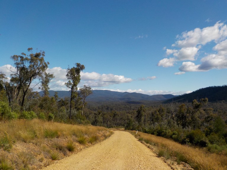
Then we’re off to play in the forest again, heading up Playgrounds Road. We will see no more cars or people today. The road combs to start along a wide fire break. The peaks and ridges to the north in Mt Elizabeth Conservation Reserve peek through the fog. The fire doesn’t look too terrible over there, but it’s burnt hot over on the other side.

We hit 59.4 kph somewhere on that steep ridge. It’s all rollercoaster ups and downs on slippery gravel with water erosion troughs running parallel with the road. It’s dicey but fun. I keep as much speed on the downhills as possible to fling me up the steep grade on the other side of each dip. Two of the drops are exactly the same: left-hander into right-hander and a steep scoop at the bottom of the next incline. But, at this point in the tour, I’m getting good at scoping which of the two tire tracks to be in and how to swap over the slippery gravel accumulated in between. Yee-ha! I’m able to ride all of the steep bits today with the aid of gravity and momentum.

On this trip, I’ve come to love the descents off ridges into the jumbled creeks below. The forest seems to rise up all around as you descend into the labyrinth of convoluted maze-like drainages. The lyrebirds start up their calls, the road inevitably gets rockier and clings to the edge of the ridge it’s been built into. You feel as if the bush is swallowing you into its guts, way down deep below the ridges and away from the sky and any contact with the outside world.


The bottom of this labyrinth is the junction of the Timbarra and Tambo Rivers. We rode above the headwaters of the Tambo on the day I started to come down with Covid. We rode above the start of the Timbarra the next day and camped next to it only a km or so from its source the next day. And so here we are at the mouth of the Timbarra and far down the Tambo.

The campsite here is just okay. It’d be hot on a typical summer day as there is little shade. The flat bits for setting up camp are a couple levels above the river, though all of it would go under during times of high water. There’s a fair bit of evidence of this – large branches caught way up in the trees fifteen or so feet in the air. That much water seems impossible, but wow, would it be amazing to see when it was in flood like that!


I just spend the day hanging in the shade of a tree on the riverbank. There doesn’t look to be any good places to camp, or any reliable water sources for the next 50kms, so it was a short day to position ourselves.
I enjoy looking at all the rock types in the river and think of my dad while I spend quite a while searching for flat stones and then skipping them. You always want to hear a ‘thwack’ sound on the first go. That’s going to give you a lot of skips. If you hear ‘thunk’ – you’ve wasted a rock.
I catch up my journal. The guys go for a long float until the wind gets gusty and I’m afraid it will overturn them. However, the wind is late. It was supposed to be a 20-35 kph northwesterly in the morning, but it doesn’t arrive until 1.30pm and isn’t constant until 4.30pm or so.


I watch the clouds change from fog to stratus that then breaks up to become fluffy cumulus, all pushing by on a northwest-southeast track. Then, the high wispy feather clouds come, shifting southeast ahead of the front. Then the speckled clouds arrive, like a roller brush that’s almost dry spreading the last bits of paint. Then the thicker, matted stuff arrives.


My bed on long grass tonight is super soft. There is rain in the night, but it’s never heavy and it never storms.
3 February 2023 – Tambo River Junction to Buchan-Orbost Road – Gunaikurnai Country – 87 kms
At 6am there is low fog and all is covered in gray. You can’t see higher than 40 feet above the ground, and there are wisps of moisture scooting along the river. Everything is saturated. No thank you. I sleep a bit more.
By 7.30am, the fog has cleared and bright sun makes all the water droplets on the long grass sparkle. There’s no way I’m getting out of here without soaked clothing and feet!
I’m packed up quickly and ready to tackle that vertical road on the other side of the road that will lift us out of the deep, incised river valley.
It’s so steep, I’m afraid I’ll have to carry the panniers up and then the bike. But the rain last night has made the surface stick together a bit, so it’s not too slippery. Plus there are bigger rocks where the mountain itself is exposed that help give traction. It is still hard work though, and it’s a combination of keeping my body right above the handlebars and simultaneously pushing and pulling the bike upwards with each planted footstep. Very slowly we shuffle the bike up.
Yes, the secret really is to keep your weight on top of the bike on stuff this steep. It’s hard on your shoulders though, because your elbows are tucked in and so you don’t really have your arm muscles to help. If you push from the side/behind with elbows at 90 degrees or further… you are done for. The front wheel will slip out and the bike will fall sideways.

So the first kilometre of the day takes forever. Then it’s more steep climbs and descents in and out of drainages skirting below a mountain through heavily logged and clear cut forest. Those first 8 kilometres take me almost two hours.


A guy in a ute passes me in this bit. I hear him coming long before I see him. Knowing he won’t be expecting to see a cyclist, I get off the road before he arrives. As he goes by I can see him crane his entire body around to check me out (talk about distracted driver!). I’m sure he’s thinking – that’s a woman on a pushbike way out here! Where’d she come from?
Somewhere after Old Omeo Road, which seems to run in an odd direction to head there, we finally get to a ridge top and there are more manageable grades. We eventually get more down than up until one last climb to a knoll where they’ve recently decimated the forest.

At one point, I did blow by a Forest Fire Management Team. The guy was out mowing around a small dam water point, and there was a woman fiddling with a radio in the ute. She startled as I crunched by quickly on the gravel downhill.
The road spits me out at the end of the road to Buchan. I pedal up the final few hundred metres of that to the Bruthen Road. Luckily, my next bush track is just diagonal from the intersection, so I don’t really have to ride that main highway.
Stoney Break Track is nicely treed. After riding through so many logging coupes this morning, it’s nice and soothing.


We get into it and the track rolls down in a very flowy way and it is so fun! Eventually we drop down to Stoney Creek with a really steep climb out. Then there’s a long gentle climb through that enclosed forest on Lambournes Track. Rail Crossing Track sends us flying downhill and into a skidding ‘yield’ to the rail trail. I laugh when I think what someone would think quietly riding along the rail trail when all of a sudden there’s loud sounds of sticks breaking, rocks clinking and gravel crunching as someone comes flying out of the forest to a dusty stop.
We ride back past the trestle bridge (good god, how many times have we seen that stinkin’ thing on this trip?). We stop at the general store in Nowa Nowa, the town where we spent four days after fixing the front tyre a couple weeks ago. I get a chocolate bar and then sit at a nearby picnic table to figure out our next moves.
The wind is still a strong northwesterly with some bigger gusts, but we appear to be the only part of the state not getting rain showers after last night’s front. But there’s a 20 percent chance of showers, and there are some clouds gathering with grey bottoms and a bit of menace.
I text Nigel my position and then think it best to keep moving. We rejoin the rail trail and fly along on easy grades and a nice new white metal surface.

We pass all the trestle bridges that have burnt down in fires in 2011 or 19/20. At Partelli’s Crossing, there are toilets, a picnic table and a shelter. Should we just stay here?


Nah, it’s close to the main highway. Will I regret this decision when it rains on me later? We follow a gas pipeline through a cleared wide area and then run out of the nice surface about four kays or so west of Waygara. The trail is a bit rocky and would somewhat suck on a touring bike, but at least it’s not slow and sandy.
There look to be some decent camping options at Waygara Road – nothing formal, but flat stuff away from the road and trail. But let’s keep going. We’re heading up through state forest, so maybe there will be something along the way. The clouds don’t look any worse.
We head up Ostlers Gap Road to cut over to the Orbost-Buchan Road. It’s pretty sandy gravel, and I have to get off to the side to let two gravel trucks pass from behind. A bit further on a FFM ute passes and the forest guy gives me a stony stare. The forest is an unremarkable scrubby variety with no good places to camp.

So we climb on up to the Buchan-Orbost Road. Ah, it’s sealed. It’s narrow but in good shape. It climbs and falls to creeks and moves into areas severely burnt. There’s not much traffic. There’s a cluster of six or seven cars going both directions around 3.30, but just the odd car after that.

This is a really nice ride and any of the steeper grades seem easy on such a smooth surface! I’m never even in granny as we pull those long climbs. It would have been so beautiful before the fires, but it is still a nice ride.

I look for places to camp but don’t see anything great. There’s always options though, so I’m confident if we get to 6pm or so, we’ll find somewhere we can plop.
Still, we’ve been riding a long time with a fair bit of climbing early on, and I don’t want to ride to exhaustion. So we pop out of the forest into a cleared area of private land. We zig in and out of the hills and climb to a high point with good views over the rolling, burnt hills.


The wind is still blowing hard in my face in those cleared areas, so I’m starting to wear out. Around 5pm, just past the private land is a lay-by with some gravel stockpiles. There’s a grassy area just a bit behind some trees. It doesn’t look too much like a toilet, and there’s no TP hanging around. It’s perfect – never mind that it’s not very far off the road and may or may not be legal. I don’t think anyone will bother me. My standards for sleeping locations… okay, maybe I no longer have standards.
I filled three litres of water in Nowa Nowa for a dry camp tonight, so I have enough water if I ration, don’t use the stove and just run my dusty chain through a wet rag instead of being doused.
I spread everything out to dry – it seems like I started this day a long, long time ago. It’s been 10 hours on the bike. There are some threatening clouds, but I just relax on the tarp until dark when I set up the tent.

The ground is uneven, but I align the dip with my butt and the high point under my knees. It feels like an adjustable bed. Deluxe, literally roadside accommodation. I crawl in the tent at 8pm. I’m asleep by 8.30pm.
After 5 pm, there were just two cars on the road – it’s actually the same ute going one way and then heading back the other. I love being in places with so few people that a ‘main’ road sees no cars after 8pm. Yeah, keep it coming – I love the bush riding and all the time in the forest. I’m so grateful every day to be out here and to have a body that can do this again.
Hi Emily. Another really interesting episode. I laughed at the male Teacher- Ego thing. Seems to come naturally to Teachers along with a loud voice. It’s good to read how well you are going fitness-wise and sanity-wise, the guys must be very pleased to have such a long trip away.
Hi Tony, your perception of the teachers made me chuckle and then I realised a big ego guy I used to work with had once been a teacher! Haha! My mum was a teacher – no ego but she could definitely give you ‘the look’! The guys enjoyed all the floating opportunities – I should have sent them to get/filter the water 🙂
Great to see your level of fitness has enabled you to get out into the wilds.
Great report!
Thanks, Terry. I hope you’ve been able to get out for a few rides between family commitments. Hope you’ve got a great garden in this summer, too!