

4 – 6 February 2023
311 kms (for the whole week)
Total Part 2 kms: 1319
Total Trip kms: 4567
4 February 2023 – Buchan-Orbost Rd to Mt McLeod – Gunaikurnai Country – 37 kms
The first shafts of sunlight filter through the trees. I’ve slept well in my roadside accommodation. There was no traffic through the night. The silence this morning is enveloping – no birds, no people, no vehicles. There is just the sound of a tent fly being shaken, tent poles clacking and a bike being pushed through the bushes back to the road. It’s 6.15 am, and we’re heading out hoping to beat the winds forecast to be 30-45 kph out of the northwest.
We immediately start a long climb to summit the other end of the Tara Range we rode over a few weeks ago. There are even some switchbacks as we climb up and up through tighter curves and steeper climbing than yesterday.

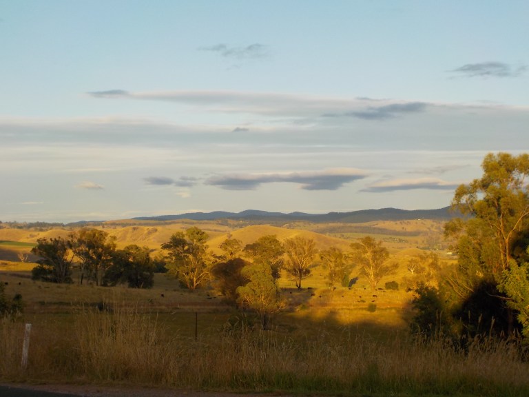
The forest has been blasted through here. I cannot imagine what it would have looked like right after the fire. The vegetation is still short and scrubby so it almost feels like you are sub-alpine with the long views over hills in the distance.
We continue through the blasted forest with a long downhill off the range through a gully where recovery seems slow. Fuzzy trees of epicormic regrowth dot the gully areas, standing dead trees dominate the ridges.
There is another climb and then a sharp u-turn at the head of a creek followed by climbing up again to good views of the Buchan River valley. This would have been such a scenic road before the fires.

Fog is tucked into low pockets and pushes against steep limestone outcrops. There is a maze of dents and ridges running to the Snowy River valley, and once again I really enjoy that topographic complexity. We emerge from the concentrated hills into a more open valley with very long views over burnt bush as far as the eye can see in every direction. Not much has been left untouched by the fire complex here.

We dash down to the Buchan River and then climb up onto the valley hillsides again. We traverse the slopes of the hills instead of riding down in the valley itself. You’d definitely get fit if you lived in Buchan. There are no flat riding options ‘round here. There is one final sustained downhill into town, but it’s just a kilometre long, and we can’t get too excited knowing we’re going to have to climb back up it after we refill water in town.


I go down to the public toilets. I fill four litres of water as it will likely be a dry camp tonight. I brush my teeth. I organise my gear. I text Nigel my location and the roads I’ll likely ride over the next couple days.
Then I look at the weather forecast and radar. Crap. The weather forecast is fine. 25 percent chance of any rain. 0-1mm. But that forecast is way too optimistic. There is plenty of rain on the radar to the west, and the sunny sky of this morning is being overtaken by a bunch of high, matted stratus clouds. It’s only 9 degrees with a wind chill of three. The cloud has taken away any radiant heat. Darn – we need to get a move on. It’s not a temperature where you want to be riding in rain.
So I quickly head down to the roadhouse, get some corn chips to bolster snacking supplies and to act as a delivery mechanism for getting Mexican-spiced rice and lentils into my mouth. I also get an OJ for a change from water, water, water.
We ride back up the hill we came down into town for 3 kms and then turn off on Basin Creek Road. This road takes you down to the take-out point on the Snowy River at Balley Hooley (where most canoe trips pull out), so it’s a well-used road. I haven’t seen any traffic at all today, except in town, so I can dodge all the corrugations by riding on the wrong side of the road when needed.
The road climbs around a steep, bald hill and then flies down through some twisties to a curved bridge over the Murrindal River.

The old, historic bridge built in 1927, burnt down in the 19/20 fires – only the concrete foundations remain. It was still open to cars right up through the early 2010’s and remained open to pedestrians until 2019. At that time, when structural failures meant it was unsafe even for foot traffic, the local council noted they were trying to figure out what to do with the bridge (it had heritage status but they wouldn’t have had the money to rehabilitate it). I guess the fire answered all those questions!
Some pre and post-fire pictures here:
We head up a decent grade away from the river to a decision: head up Tulloch Ard Road through private property and get as far as we can into the forest beyond, before the rain comes, or go through forest instead of farmland up the Old Basin Road to a campsite on a ridge marked on my map. Hmmm…. let’s try the forest thing. I think we can get to that campsite pretty quickly. It might have views.
On my map, Old Basin Road is a straight line through hilly country. You know what that means: steep ups and downs. It’s pretty tough going right from the start. It takes us up out of the Murrindal River drainage and to the top of the Snowy River drainage.
The forest is a lot of wattle scrub through here, so that campsite might suck. But we’re committed now. If this doesn’t pan out, it’s not a big deal, as the road loops back to the main Tulloch Ard Road. We just waste a bunch of precious time.

At a t-intersection there is a choice to go down to Balley Hooley to the south or Basin Creek Falls to the northeast. But these are steep drops down to the Snowy River, and I don’t want to filter that water, and I don’t want to be around all the campfire smoke of other campers… so I give it a miss.
Instead we climb high on a ridge on Balley Hooley Road toward the campsite marked on my map. This would have had good views down into the Snowy River valley, but it is all hemmed in now by wattle scrub.
There are a couple steep climbs on big, loose gravel and we never see the informal campsite (i.e. small, cleared area) on the map. In fact, I’m not quite sure how far along we are on the road for awhile. But we eventually come to some private property and a very steep climb that I have to push the bike up. I walk in the grass on the side for traction, but it’s still slow and difficult to get the bike to the top. And then…
The road pops back out on the Tulloch Ard Road that we could have gone straight up. We’ve wasted 45 minutes to an hour for nothing, and the sky is now completely overcast.
Tulloch Ard Road has a pretty steep grade to start as it climbs through a drainage between a ridge and a small peak named Mt McLeod. There used to be a fire tower up there, but I’m not sure if it does now. The fire came through here hot.
At the turn-off to Mt McLeod, there are some old logging tracks that run up the hill opposite. There’s an open area not in danger of falling branches that’s flat enough to consider for the tent. It’s only about 20 metres off the road and well in sight of it.
But, a couple warning rain drops have already fallen. So, yeah, this will be fine. Another bit of roadside accommodation, but again, I haven’t seen any traffic today, so I don’t think it’s going to be an issue. Let’s get set up before that cold rain comes!
My legs have already done a fair bit of climbing today after a big day yesterday, so they will appreciate not going further. So up goes the tent. Just in time – it starts to rain just after I crawl in.

I take a 2-hour nap that I probably really needed. Then I catch up my journal, look at maps and just relax. I enjoy listening to the rain on the tent, knowing that I’m warm and snug and not riding in it. There are more showers on and off through the day until about 4pm. Bits of sun start to peek through around 6pm. Yes, we’ll be good to go tomorrow!
5 February 2023 – Mt McLeod to Forest Creek – Gunaikurnai Country – 37 kms
Last night it was totally silent. Two roadside tent sites in a row with complete silence. No human noises, no annoying barking dogs, no cockatoos being obnoxious. Ahhhh, how lucky am I?
Our road tops out at about 900 metres today. We’re sitting at 400 here. I can see a ‘picnic area’ marked on my 2014 map that is no longer shown on more recent maps, the More to Explore app, or on tourism websites. But it seems like, even though it’s not all that far away in distance (35-40 kms), it would be a good spot for the night to keep our total climbing a bit more reasonable. It will also have access to water which I must find somewhere today.
So off we go. I don’t care about distance anymore. It is a very poor indicator of effort on roads like these. I gauge a day’s difficulty on total elevation climbed now and don’t take any note of how far we’ve gone – only recording it in my journal to give an idea of distance for future rides when I come back this way someday.
My aim is to keep total elevation each day to 1000 metres or less. Whether that comes in 20 kms or 60kms… the effort that goes with that amount of climbing is just about right for a day. You need a formula that includes cumulative climbing, steepest and average grade, time elapsed and surface condition to really know how hard a ride has been. Distance really doesn’t come into it at all.
As I commence a long climb through the forest, winding around low peaks and swapping from one drainage to another, I think about how proud I was to climb Beartooth Pass and Trail Ridge Road. They were feathers in my cap. But really, almost every day on this trip has been a harder day than either of those. They were sealed roads and had consistent grades generally below 8 percent. Total elevation climbed and altitude were factors in climbing those roads, but I still think this is the hardest riding I’ve ever done, particularly since it’s been pretty continuous. I’m so, so grateful to have the health to do this again.
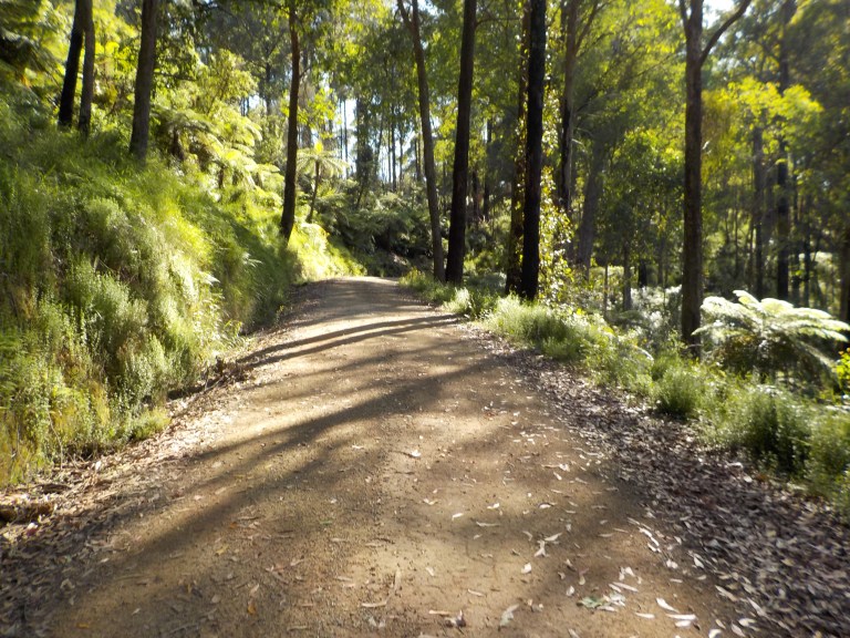
We have a short little climb and then a few kilometres curvelineating around Mt McLeod that are easy going with good views through the burnt trees. We pass through private property saddling a saddle and then the real climbing begins. Up, up, up, the road curves ever upward, cut into the side of the slope as we climb the ridge around The Basin to the east. This area has escaped the fire, or burnt only lightly, so it’s super green, lush and diverse.

We can see the ridge we’ll climb up to, off to our right through the trees. It seems daunting, but I know we’ll be fine. I’d love to see this from the air, that big basin surrounded by 800 metre tall walls.
The surface is good. You could do this all on a touring bike – with more curse words, of course. I’m not sure if this direction is harder than riding in reverse, but today is quite manageable. Orginally, I was going to do this the other direction after linking into it from the Nunnett Plains. But Covid interrupted those plans and we rode straight to Buchan. However, we’ve circled back to come here now, because I didn’t want to miss this road.

All of the steepest climbing is in the first 15 kms to Ash Saddle. It really is a nice ride. I’m surprised it’s not advertised more widely as a tourist route, as it is all 2WD.


200 metres before Ash Saddle, where the mountain ash form an uninterrupted, tall canopy for a couple kays, one of those Overlander world travel expedition type trucks passes me. It’s odd though – it has a tray on the back instead of a box. If he had come along 3 minutes later, I’d never have seen him. Still, 2.5 hours into the day before I see one vehicle is not bad.


After leaving all the gorgeous, but not huge, ash trees behind, there’s some nice downhill kays along a gully before we climb back to a ridge.
We take the 1 km track down to the Tulloch Ard Gorge lookout. It is just barely 2WD now, but won’t be soon if they don’t fix all the erosion on the steep bits down to the parking area. I think some people in a car would be a bit surprised at how steep and rough it is, given that this site is advertised widely.
There’s a small parking area – don’t try to get a caravan down here and turn it around. Too bad there isn’t a picnic table here in the shade.
The walk itself descends, steeply at times, 1.6 kilometres to the lookout. It’s burnt pretty hot through here and there is lots of shrubby regrowth. There are resting benches along the way that have been put in post-fire. The lookout has been rebuilt, too, but it’s not really a gorge lookout which is disappointing. Instead it looks up the Snowy River just before it enters the gorge. Rafting this section of the river is still on my to-do list. I’d love to do it with Nigel, as he’d really enjoy it, but his mental health needs to be better before we subject innocent people to three or four days of his head.


While we can’t really look down into the gorge, the views out over distant ridges upon ridges are impressive. We’re looking over some pretty remote country from here.
I hike back up to the parking area and pick my way back up all the steep, eroded track back to the main road on the bike. I’m glad not to have met any vehicles to break my groove, or I would have had to get off and push. The grade is steep enough that you wouldn’t be able to get started again if you put a foot down.
From the main road, we have just a few curvy downhills to our turn-off. We see an old couple out for a Sunday drive who seem to be driving more slowly than I could ride. That would be a hilarious, slow-mo overtaking if we were heading the same direction! Pretty awesome to only see two cars the whole day on a Sunday though. Yippeee!

We drop down to Forest Creek on a road that appears not to get much maintenance anymore. I wonder why? We even have to get the bike over a small tree that’s fallen across the road. There are no recent tyre tracks. Maybe everyone comes from the other direction, as it eventually comes out on the main Buchan-Gelaptiny road.
We drop through burnt forest, to lesser burnt forest to no burn at all along a creek. Sticks go flying, leaves fling up and float for a moment, and small pieces of rock ding the bottom bracket, as we zing down the hill to the creek.
There’s a decent-sized open area with not a lot of shade at the bottom. There’s no one down here. Ahhhhh….. I claim the picnic table which is ancient and deteriorating. The fire ring charcoal looks to be a few weeks old. I sure hope no one else comes tonight. This is soooo peaceful.

The guys are super happy as the creek is picturesque with ferns and tree ferns lining the banks. They will float the rest of the afternoon away in the shade – happy crew members out and about in their habitat.

I cook up a late lunch on the stove. To conserve water, I don’t cook on the stove on the nights of dry camps, like the past two. This means my peanut butter and rice cake supply from Bairnsdale five days ago is getting a bit low, but I’ve got plenty of rice, lentils and porridge. Fuel supplies remain good, too. So it’s lentils and rice noodle soup for lunch – what a luxury!
While I wait for the water to boil, I get the tent set out to dry, the camera charging on the solar panel and plan out my chores. I need to filter water, clean my clothes, have a bucket bath, write the journal, and generally take advantage of the sun today for charging and drying since the next few days are forecast to be cloudy. I also need to do a bit of patching on my fork bags.

So it’s good to have a short ride day time-wise to do chores and use the sun. I really, really do love being self-sufficient, though, and having everything with me I need on the bike. I think this rough, remote bush riding and being totally self-sufficient really is the pinnacle of cycling. Well, maybe the pinnacle is doing this in central Asia or South America, but I’m so glad I finally am able to add this to my cycling resume. I’m not sure I will ever want to go back to sealed roads and going through towns every day after this ride!
6 February 2023 – Forest Creek to Timbarra River – Gunaikurnai Country – 74 kms
It’s cloudy and foggy, and I’m still tired when I wake up. We’ll need a proper rest day soon. Our cumulative climbing over the past four days has got to be adding up to some big numbers now.


Like all the other days we’ve dropped off a ridge to camp near water, we’ve got a steep climb back out first thing. Nothing like steep climbs on cold muscles. It’s about 1.6 kays and over that small, fallen tree again back to the top.
We soon climb into open country with huge views. The views are, of course, limited by the early morning fog. You still get a feel of the remoteness, though, just looking at ridge after ridge into the distance.
I fantasize about owning this huge block of land carved out of the steep hills and letting Nigel have a place where his head could roam and recover and wasn’t so constrained. I think about it as a wildlife sanctuary where Nige could care for the wildlife and that would in turn care for his head. But could you imagine an asking price for a property so prime and large? I’m sure it’s been in the same family since settlement and would be unlikely to ever be sold.


I keep seeing sheep poo, but no sheep in the paddocks. Finally, as I climb some more, I see them in a paddock close to a house. Maybe the wild dogs would pick them off if they were in a more distant paddock.

As I ride through the property, I count at least seven different kinds of cattle and think that some might be Murray Greys – they seem to have that sort of fuzziness and head shape. Sheesh – I wonder what the value of the property would be.
Finally, there’s a downhill that takes us to the main road. The original idea was to go grab Glenmore Road that we missed on the first round into Buchan due to Covid. But I just can’t talk myself into it or get excited about it. The fact that that area appears to all be in fog doesn’t help.
Plus, I have this nagging desire to ride the main road back to Buchan. I’ve only been on it once before in a mini-bus- on my very first trip to Oz in 1998. I remember really loving the steep hills and how the valley sits down low with tall hills on all sides. I really would like to ride this as a celebration of 25 years since I first saw it. The Barry Way and the drive into Buchan was one of my most favourite days on that entire 6-month trip.
So once I get back to the main road, I head back toward Buchan instead of to the Glenmore Road. We immediately have some big, long climbs to get up to Butchers Ridge. There are no ‘easy’ roads around here.

But after Butchers Ridge, there are more downs than ups. Riding up out of the Murrindal River is a bit long and winding, though, and the flies are atrocious. The views are nice, but we’re trailing flies like Pigpen trails dust. I don my sanity net and that makes them bearable. The tremendous views and very light traffic as we curve through the valley and snake up the hills makes it all worthwhile, though. I’m also intrigued by all the different levels of fire intensity and the amount of recovery in the vegetation.
W Tree Falls is just a trickle. I don’t mind. I saw gushing waterfalls in the first half of this tour, and I know the weather that accompanies that.


This is such a scenic road, and I’m really happy with my decision to go this way. The Buddhist retreat is up for sale, and there’s a tiny, tiny home on one block just off the road also for sale. It has amazing views, but that would be hard living on such a steep block without any utility or water connections.


The fire has burnt ferociously near the quarry. But the road beyond the quarry is a blast (pun intended). There are huge views, a road that is trying to crumble off the edge with massive drops and the ever-present threat of a b-double gravel truck coming from behind. Woo-hoo!

The last couple kms into town are so fun and fast as we curve around a huge hill with the Buchan River coursing through the tiny valley below. A guy in a ute going the other direction gives me a happy toot and a big wave. Yee-ha!

I get a burger from the Roadhouse to get some iron and b-vitamins in me. It’s a toss-up between that and one of the excellent salads from the cafe. But I think some red meat is a higher priority as I’ve only just eaten the last of my veg yesterday. I woke tired and hungry three hours ago and have done 47 hilly kms. I think the burger will give better energy. A litre of OJ goes down a treat, too. I laugh when I hear a bunch of motorbike guys talking to each other about how hard their ride has been today.
I then go next door to the Willow Cafe. The owner remembers me from last time. I get a slice of the Persian Love Cake, that I’m in love with, to go. I put it in my cooking pot and it travels fine.

The burger has given me a sense of renewal and I feel ready to tackle the Ensay Road. But first we have to do the 4 kms of twisty climbing up the main road to get out of town. And we get to do it with all those b-double gravel trucks! But I have room to get off the road for them when they go by, and the one guy going into town even waves.
We then ride the undulating hills to Buchan South before turning off onto the Quire Road. When I rode through here in 2017, I remember looking off to all of the hills to the west and thinking how much I’d like to explore the area. So here we are!

There is beautiful climbing through the open hills on a road that pulls us gently up through some residential blocks and then along a wide firebreak. There are two steep sections as we climb past another section of private property. The surface is good though, so the stressed chain just clicks and I grunt our way up in the heat of the afternoon.


More up and down. More good views at the top of each ridge. No traffic. I’m loving this road. How grateful am I to be able to come back to see this area. The flies aren’t bad, there is no wind, the sun is shining, and we just ride and ride, a tiny dot on the surface of the earth moving forth slowly and quietly. It’s human power and engineering mechanisms combined to work with physics and physiology to drive us forward. I could do this for the rest of my life!

We drop steeply to a creek. I am hoping I can get water and maybe camp here. As much as I’m loving the ride, I’ve done a heck of a lot of climbing already today and don’t want to overdo it since I was a bit fatigued this morning.
There is a spot I could put the tent if I had to, but the water is a no-go. It’s pretty much stagnant with cloudy ponds of water and only a trickle between. So on we go.
Up, up, bit of down, steep up. And on and on. We get up to where the Old Omeo Road comes in. We passed the other end of it on Kenny Road on our way out of the Tambo/Timbarra River junction. But now I can see how the Omeo Road hooks into this one. I love traversing the landscape from different directions and creating a map in my mind of the roads and terrain. I love that I will have seen Mt Elizabeth from every direction on this ride.


So the road very nicely dives down as we merge briefly with the Mt Johnstone Road. We get fantastic views as we drop… and then climb again. At this point, my body says we do not need another climb. We’ve had enough.
And thank goodnes, that is it. We soon have a steep, 1.5 km descent to the Timbarra River. Just before we drop, we can see our climb out tomorrow. Ugh. But hey, that’s for tomorrow. Let’s scream down this hill first. Yee-ha!

Just before the river there is a campfire ring next to the road. A little beyond that, in very lumpy grass, is a site perfect for a 1-woman tent. I wedge the tent between some blackberry bushes and big thistle and then get everything out to dry and/or charge off the solar panel.
I go down to the river with the guys. They float. I go for a dip. Ahhh…. that feels good. The afternoon has been quite warm and dusty. I skip some rocks. I watch a huge goanna lumber up the road with its awkward walking gait. I then eat some of that divine love cake. Seriously, go to Buchan just for that.


I’m loving the fact that I haven’t seen a car since the main road at Buchan South. The forest, all its burnt hectares, is mine tonight. I won’t see a car again until I’m crossing private property tomorrow, 2.5 hours into the day.

The little dips in the grass are just perfect for a comfy bed in the tent, and I sleep deeply in the quiet with only the sound of the river passing by on its downward course to the Tambo.
More great riding days .. plenty to look back on when engaged in work once more. You must be so fit now that you would be able to ride anywhere. The problem is finding enough country free of people – any sort it seems ! Wouldn’t it be nice to be able to buy a spread out there to set up that home, place for Nigel and enjoy the animals. We need “pipe dreams”. Your rides kick mine along.
Thanks, Tony. Yes, I built a great level of fitness on the trip, but I’m sure I lost it all in the 6 weeks I didn’t ride in April and May when doing the job apps and interviews, and then going down to COVID for a month! I’m going to a gym now to learn correct free weight techniques so I get stronger and retain that muscle mass as I get older.
Not so sure I’d ever want a home, but if I ever won the lottery, I would love to find Nigel a big property where he could become a wildlife carer and not have to drive trucks anymore.