

7-10 February 2023
311 kms (for the whole week)
Total Part 2 kms: 1319
Total Trip kms: 4567
7 February 2023 – Timbarra River to Swifts Creek – Gunaikurnai Country – 55 kms
I imagine the river with fire all around, the roar of energy, the heat, the trees flaming like candles as the bushfire crowns. I imagine the animals fleeing ahead of the fire front as it creeps or races across the ground. I imagine the wombats heading to the depths of their burrows and the lyrebirds stealing some space in the burrow, too. I imagine the reflection of all that orange on the surface of the water, as the firies come to fill up their tankers. And then I imagine the black and the silence afterward when ash still flutters down from the sky and smoke still curls from stumps and snags still burning deep within the wood.
The fire has long since passed, and the forest is three years into recovery. I think about the intensity of those days and the slow process of recovery, as I climb that steep ridge out of the river in the morning. Some things exist or proceed on scales too big to comprehend. I wonder if our little human minds will be able to stretch to comprehend these sorts of events as they become more common. Will it become like gun massacres in America – where no one even really shrugs their shoulders when 15 people die in a spate of violence anymore? Will we just resign ourselves to it and say, “well there’s nothing I can do”, when we hear that another fire has burnt 80 percent of the forests and killed more than a billion animals? Will we ever fully understand what a billion means? And what that means for ecosystem health?
So I ponder deep things as I climb the steep hills. As much as I never, ever, ever want to hear someone use the word ‘unprecedented’ again (could we just go back to ‘record-breaking’ please?), I also wonder how ‘in-your-face’ it’s going to have to be before we take transformative action so that my friends’ kids have a future that isn’t dire and catastrophic.

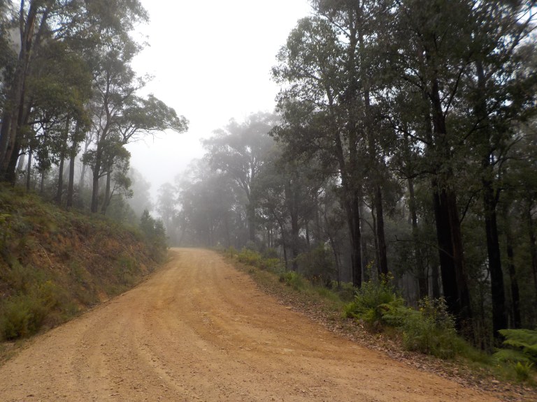
I make it up that first steep hill okay. There is plenty of more climbing to come as we round the corner and traverse from ridge to ridge, elevating ourselves to the upper reaches of the tributaries of the Timbarra. Fog still lies about the higher peaks. Mt Elizabeth, and the peaks in that range, stay hidden behind cloud with only a glimpse here or there of a forested ridge.

I enjoy this winding, climbing road though. It is quiet and the temperature is cool. I’m not sweating but my nose is not too runny either. There is no traffic. So it’s a pleasant ride that is peaceful and calm. At times, all I can hear is the sound of my breathing and the crunch of my tyres on the gravel. There’s plenty of time to ponder those deep thoughts about life and still plenty of time to think about nothing at all.


I do pass what I call the ‘toilet cleaner’ bush again today. I’ve passed by this species quite a few times now. It seems to like to hang out in the 600-800 metre elevation range. There is some brand of eucalyptus scent toilet cleaner that smells exactly like this bush. Give that biochemist a bonus, because they’ve got that scent spot on – so much so that here I am in the bush thinking toilet cleaner instead of knowing what species on which they based that scent.
It’s funny how you pass by plants that make you think of other things. Back near Deptford on the Engineer’s Road, some plant smelled a whole lot like sage, so much so that I started craving roast chicken! Another day, there were a few instances where some plant smelled a lot like marijuana (maybe there was a clandestine plantation nearby).

At the very top of this tributary catchment, a road dives away to the south. It would take us back to the junction of the Tambo and Timbarra rivers where we camped five days ago or so. In front of us is a very steep pinch to get us to the ridgetop before we drop into the Tambo River reaches.
I don’t quite make it without having to get off and push. The Timbarra is not letting us go easy. This is our last call for the Timbarra on this trip. We camped near its source, down at its mouth, and last night we camped somewhere in between.
Once we get to the top, I take the opportunity for a pee break while I’m already off the bike. I tempt a driver to come along by just peeing right on the side of the road. Nup, not much traffic on this road – no one comes while my shorts are down.

The views as we come off the ridge are fabulous. If only it weren’t foggy, you’d have even more fantastic views of all the lumpy ridges of the valley that divide the creeks flowing into the main Tambo River. Then you’d be able to see all the higher ridges on the opposite side of the valley – they are just cloud-covered now. But still, it’s gorgeous – this has been a tough but fabulous ride on this road.

There’s a lot of opening and closing of gates on private property as we descend that complicated jumble of cleared hills that seem to roll right across the valley to the next range. We ride through these high paddocks with young bulls and steers. It always makes me a little cautious to ride through a paddock with animals with testicles, especially ones with heads broader than my chest!
As we roll down the hilly spurs, I see a cattle truck that’s just pulled off the road near a shed. Good timing – glad not to meet that coming up the hill. Then, finally, I see my first car since Buchan South yesterday in the early afternoon. It’s an SUV, and I actually think it’s the one I saw parked at a house on this property a few minutes ago.
We just keep going down and down and down. Yee-ha! It’s a good thing, too, because the flies are bad and would be horrendous if you were heading up at climbing speed.
Eventually the road dives down into the creek and follows it along in an impossibly squiggly path through the hills. It’s a big guessing game of ‘where does the road go’, but not having a height perspective to guess.
I have no idea where we’re going to meet the main highway, but I can see it slashing across a hillside to the left. But our road swings right and then takes a sharp bend down and across a low level bridge over the Tambo. It’s a very sharp left turn coming off the bridge, and so that is a wee bit dicey when taken at speed.
I stop at the intersection for a gut/snack break. I take the time to study the traffic patterns on the highway. I need to do 4 kms on this to get to another back road. It will be 4 kms of blind corners, hills and no shoulders, so I want to see what the traffic looks like. It appears it comes in bunches, and though the speed limit is 80 kph, many vehicles seem to be going 100kph.
So I take off after once bunch of vehicles and ride as fast as 2.8 inch knobbies will go on chipseal. I’m doing 27 kph and hammering it down – which is good because, in a couple places, there’s 100 metres or so at a time where the cliff wall and gutter give me absolutely nowhere to go if a b-double comes barreling up behind me around a blind corner.
It’s beautiful, with the river right there winding along below the cliffs, but it’s also tense and dangerous. The road is in terrible shape, too. Some of the seal has been pushed up on the road edges to pedal height. You don’t want to clip that! There are signs all along saying upgrade completion mid-2021. I sure hope they were delayed by Covid and this isn’t the upgraded conditions! The Great Alpine Road (B500) is considered the worst road in VIC, and from these 4 kms, I can certainly see why.
I’m lucky to only be passed by two cars and a caravan before my turn-off, so thank you to the road gods for safe passage. Doctors Flat Road is a very nice reward. This is the original road, before they rerouted it over a big hill. This road continues to follow the river, flat at times, but gently climbing occasionally where the road has to climb along the cliff or go over a hill when there is no room for both the river and the road.

And so goes an incredibly pleasant 16 kms. The river is carved right in at the base of the mountain range on the west side of the valley. It’s like the river is tickling the toes of the spurs that run down from the main mountain range. It’s quite picturesque to have the range rise right up on one side, the river right down below, and the steep cleared jumble of hills on the other side. The fact that it’s been freshly chip-sealed is a bonus – though it will ride even better in a couple months when all the stray chip has been flung to the side. I only get passed by three cars on this road – one occupant being a woman with a huge smile who waves big, too.


I miss the next back road at the intersection with the B500. I don’t look at the map close enough. You need to turn back south, cross the bridge, go up another road for a tiny bit, and then the back road takes off from there. I turn north on the main road, thinking it will come up shortly to the right. It never does. Thankfully, the main highway through here is much wider and not hemmed in by cliffs and the river, so it feels safe enough. I only get passed by one truck.
I’m trailing a touring cyclist through here. I saw him go by when I was at the intersection drinking water. He’s wearing fluoro (good on him!) and has a very heavy load. However, I figure he must be on an e-bike because he’s flying along without pushing the pedals very hard with that big load. As I ride, I can see him ahead occasionally. He’s not pulling ahead, but I’m doing 25kph just to keep up. I still can’t see e-bikes as bikes – to me they seem like mopeds. I’ve never seen an e-biker yet that is putting in the same effort as someone on a regular bike to go the same speed. It may be my future, but man oh man, I hope it’s 35 years from now. (Oh, wait, I’ll be dead in 35 years – make that 30 years from now).
I meet the rider in town – a guy in his 60s. He was house-sitting in Sale the past coupla months so he is out-of-shape. His butt hurts even though he’s only ridden from Bruthen today. He rides four months of the year, sea kayaks four months of the year, and works 4 months. He is staying at the caravan park because the Ensay pub is not open today, and the pub here does not have accommodation. He only stays in his tent when there is no other option. He eats all his meals in pubs and cafes. Last year he rode 10 of VIC’s rail trails. But he didn’t know about the one in Bright (he must be only person not to – it’s the most famous one). So he’s heading there to ride that on his way to Mission Beach to pick up his kayak. It’s just another old guy that is full of himself in the way he talks.
I ask how he went travelling during Covid restrictions when all the state borders were closed. He says some places wouldn’t let him in because he’s not vaccinated, but the outback pubs didn’t care. He’s talking to me as I’m cutting up veggies and steak to make a taco salad. When I don’t offer to share (he underestimates how many calories I’m burning and replacing!), he loses interest in the conversation (that was all about him anyway) and wanders off to the bakery. I’d gotten a good deal on the steak at the supermarket (well, it was more like a tiny pantry) on my way into town. So good riddance old rich guy, let me eat in peace. Of course, you know if it was someone I could relate to that wasn’t on a big Boomer budget staying in accommodation every night and eating out for every meal… I would have definitely offered to share! But he doesn’t need my food if he’s got money like that. I didn’t care much for him anyway, and to be honest, I didn’t really see him as a touring cyclist anyway.


I then go to take a shower (first one in six days, so I’m soooo ready). Only the key I got from the supermarket (where you pay for the campsite) doesn’t work. Hmmm… I try again. Nope. I try the disabled toilet. Nope. I try the laundry. Yep. So I try the key in the toilet door again. I jiggle. Nope. So I go try the men’s door. Yep. Hahahhahaha! I’ve been misgendered a lot on this trip since I wear very androgynous clothing and don’t have much in the way of boobs. The funny thing is that I talked to the supermarket lady for several minutes, and I usually find that my voice gives me away if my body does not.
So I do what you do. I just go take a shower in the men’s room. While I’m in there, I see that the e-bike guy has plugged in his bike batteries into the powerpoints by the sinks. What an arse!! It’s a council-run caravan park. No one is making money off this venture. It’s $16.50 for an unpowered site. It’s $5 more for powered. You can afford to eat all of your meals out and have roofed accommodation every night, but you are too cheap to pay for a powered site? What a bastard. I’ve got no problems with people charging their phone or tablet in a camp kitchen or toilet, but if you’ve got anything bigger than that… pay for a powered site! Electricity is not cheap and you are giving cyclists a bad name, you moped rider man!
The only problem with the shower key being for the wrong sex is that I’m hesitant to go to the toilet as more caravaners arrive. So I hold it, and hold it and hold it until long after dark, and then I slip off into the shadows to pee. Aahhhh. I’m very much a camel, but that is a relief!
I talk to one guy in a ute who’s got a heap of fossicking equipment in the back. He’s from Albury and spending a couple weeks out looking for gold. He talks about some good places to find gold (knowing I’m not going to barge in on his secret spots). Ha! I keep meeting guys from my town out here in the bush. Maybe it’s because a lot of us live in Albury so we can be close to the mountains. He also adds to my tally of lonely old guys out looking for gold – I met heaps of them back in the first part of this tour.
I don’t sleep well. The ground must not be bumpy enough. When I get up at 5.30am, I’ve probably only managed four hours of sleep. We need a rest day soon!
8 February 2020 – Swifts Creek to Groves Gap Road – Gunaikurnai and Jaitmatang Country – 38 kms
I’m good at packing now. I manage all those fiddly straps really well. I can do them up pretty quickly now. But they’re still fiddly. However, we are rolling below the streetlights and their orange net of light on the pavement by 6.00am. The town still sleeps, except for one lone runner with heavy footfalls literally pounding the pavement.
I slide the men’s amenities block key under the front door of the supermarket, connect to the internet to download the latest forecast so I’ll have it on my phone for reference the next few days without service, and then roll on out of town.
We ride up between two tight hills to Brookville Road. When I came this way in 2017 on the back way to Omeo and saw this road taking off between the hills, I thought, “someday I’m going to have to go that way.”
The hills rise up steeply, naked at the bottom with a bit of tree fringe at the top. The grass has gone long and golden as the road imperceptibly rises up the valley between widely spaced farmhouses.

The original road is nothing but a two-track through a paddock and up a steep hill now. The current road has a steep gravel left-hander that pulls us up out of the valley and along the cleared hills. But this road has logging money, so not far beyond, the road is actually sealed. We climb up the range in a whole bunch of gentle, squiggly twisties that follow the dents of the drainages. So we go from 300 metres to 750 metres with some pretty easy climbing. I almost consider chipseal kilometres free kays these days since they are so easy compared to the other stuff I’ve been riding.
After we get up to 680 metres, we pop out into an open, upper valley and follow a creek. The road goes to gravel, but it’s been freshly graded and rolled, so it’s pretty easy riding.
A guy in a ute passes me and then stops next to the roller. I say Hi as I go by. The guy asks where I’m heading and this leads into a conversation about doing what you love while you can. Next year he wants to take off with his wife and three boys and take off indefinitely in the caravan. He’s from Wales. He moved here 10 years ago because Wales’ weather and economy sucks. (Ha – he got here just in time for 10 years of record low wages growth!). He likes Oz’s climate and doesn’t think it will get too hot in summers to come. I tell him I think it will get too hot to bike tour. He thinks the climate’s been changing back and forth for millenia, so even though we could do better environmentally, we can’t be responsible for global warming. Good god, can he not read a trend line on a graph? Has he got no concept of time? We have done in 200 years what previous extinction events did in hundreds of thousands or millions of years! But I don’t say this, I just tell him to have a good day and maybe I’ll see him and his family on the road someday.
I roll on past the grader and the water sprayer guy, who is drumming his hands on the steering wheel waiting for me to pass, and then round a corner into the forest. There are a couple huts at the edge that I go to check out, so I’ll have some building photos for the people that are into that. It’s hard to imagine an old lady lived here until 2001. It sounds like she had some mental health issues, but I could see how that could happen living somewhere so dark and tiny and difficult. She could stay here though since there is a creek running by providing access to water.


Further up the road, at the Mt Delusion track junction, we can tell where the sawmill or bulk of the old town of Brookville (pop. 500) would have been. It was a sawmilling town, but there’s nothing left, other than the open area to indicate its existence.

We take off steeply up Dorothy Cutting Road while the Mt Delusion track parallels below us in a tauntingly flat fashion. I could have taken that one, but it will take shorter kays to get to 1300 metres than this track, so it would have been steeper than this one somewhere. The tension on my chain says this track is steep enough, thank you. Dorothy Cutting Road is no joke.

We eventually do climb into all the mist and fog. The idea was to get an early start and the fog would hide all the missing trees as we climbed. It is obvious this is a focal area for the loggers at the moment. They are really decimating this section of the forest with more clear cut than forest for much of today’s ride. Wow – this forest is gone forever. I don’t see how it will ever recover with the heat and frequent fire that is coming.
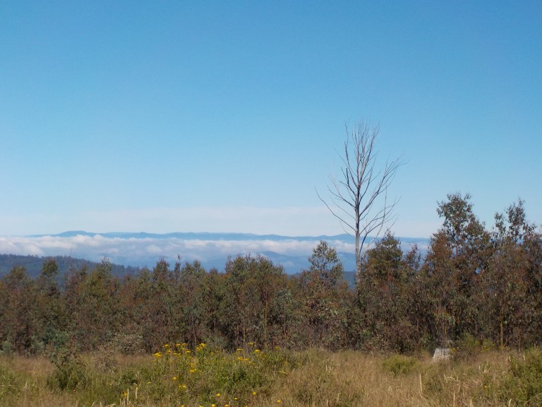
I’m hoping the fog will have dissipated by the time we get to the top where there will be good distant views. This does work, more or less, with the fog easing as we get to a few kms from our next track. First, it’s a bit of brightness in the grey, then it’s a patch of blue in the distance that gets bigger and bigger.


The fog still sits in the valleys though. So the views are of islands of ridgetops in a sea of cloud.
I head up Grassy Ridge Track, and the views are great, but it’s shocking to think it should all be forest. There are clear cuts in view just everywhere and we ride through a bunch more on our way to Groves Gap Road.

I do meet the wild dog controller who reckons he’s got the best job in the world, contracted to lay and monitor 1080 baits. He gets to be outside all day in the bush with his dogs (two mutt-looking ones who circle around me while he chats from inside his ute).
I finally turn off on Groves Gap Road. I think the clear cuts here are all salvage logging from the 2006/07 fires, but very little has regenerated. It has not recovered. It still looks like it could have been done just a couple months ago. I know it wasn’t though, because the road hasn’t seen maintenance in a loooooong time. It doesn’t look like many people drive it either.
As we descend, we arrive into an area where there’s still big trees. There are large ash, grey gum and stringybarks. I don’t see much old growth, but there are 100-150 year-old trees which look just fabulous after all the destruction in the last 30 kms.

There has been thinning done here, but there is diversity in tree age and understorey. It actually looks like a forest. To think the forest COULD look like this everywhere is saddening. It’s nothing like the awe-inspiring grandeur of old growth, but compared to all the decimation, this is just lovely.

I drop the bike at the top of O’Byrne Track and walk the 500 metres down to where I’m hoping the upper reaches of Livingstone Creek are flowing. If we can get water here, I’ll take a sorely needed rest day tomorrow.
The track is quite overgrown, and it has big trees on the opposite side of the creek that have fallen over the track some time ago and not been cleared. I can hear the creek but can’t see it. There is prolific growth, tree ferns and decaying logs hiding it.
I do need water though. We’ll have to keep riding if I can’t get any here, and we’ve done more than a 1000 metres of climbing in twenty-some kays, so we need to be done. My legs are tired.
So I explore around. Desperation means you’ll do things to which you’d normally say “Nah, thanks, I’m good”. I try to find ways down to the creek. It is never all that fun to put your feet where you can’t see them in Oz (snakes!), and the veg is mounded in places. I do manage to get to where I can actually see the creek, but this is not ideal.
So I search some more. On the downstream side, I make some headway. I break off some dead branches, clamber over a mound of something (not ants’ nest thankfully), then cross over a moss-covered horizontal branch of a fallen tree. I can then get to the water. Okay, this will work.
So I clamber back out, walk the 500 metres back uphill, eat some peanut butter on corn thins, and then head back down, clamber over everything again and take the time to fill every water bladder and bottle. I don’t want to have to do this again – all decked out in my rain gear to prevent the leeches from finding some skin to suck onto. It’s good protection but a bit suffocating in the warmth.
Tomorrow is a rest day. My legs need one. My head needs one, too. I got some sad news yesterday and I need some time and space to work through it. It’s scenic enough here on top of the Great Dividing Range with the big trees, even if I do camp directly next to the road yet again (though I never see or hear a vehicle).
9 February 2023 – Groves Gap Road – Jaitmatang Country – 0 kms
I sleep for 12 hours. I really needed that. And I guess I needed some lumpy ground to sleep better than I did on the flat, soft grass at Swifts Creek. I do wake once, and it is so silent, dark and still. We’re far away from anything human. You can hear your heartbeat in your ears here.
I stay in bed til 9am. It’s good – my legs are tired, so we definitely need a rest.
I spend the day thinking about my uni friend Ben and composing an email for his wife to read to him. He’s fought off lymphoma three times in the past 17 years, but he now has cancer quickly consuming his lungs and brain. He has weeks to a couple months to live.
It seems so impossible and so incongruent. I was with him when he nearly died in an accident back in 1995, so for him to survive then but not survive now is a whole lot for my little head to process. How can someone who lived so fully, and who has survived the knock of the Reaper so many times, finally succumb?
After uni, he went off to work for the BLM, but quickly became disillusioned with all of the damage done to rangelands by cattle grazing on incredibly cheap cow/calf rates. So he went back and got a teaching degree and has been teaching high school science for the past 20 years. Even though most people will talk about how ‘he leaves behind’ a wife and two teenage sons, I think his life’s greatest contribution is not family-related but rather his sponsorship of the outdoor club at his school. He’s introduced hundreds of kids to backpacking, hiking, kayaking, rock climbing, etc and taught them Leave No Trace ethics and respect for the environment. That is perhaps the biggest loss.
So I think of Ben and all my NRM friends from uni days. I think of the night rides, the football game parties, the traipsing around to streak parties of people unknown. Those really were some of the best times of my life and I’m grateful for those memories and the enduring friendships. I get the email composed – I’ll send it tomorrow when I find some phone service on a ridgetop. I’m high here, but there is thankfully too many trees.
After a good cry and working through it all in my head, sitting there amongst the big trees, I feel better. My heart had been feeling so heavy, heavier than my legs with all that climbing in them.


The predicted showers come as rumbling storms from about 1pm. We’re up above 1300 metres right on the Great Dividing Range here, with water on one side heading inland to the Murray River and water on the other side heading into the Wentworth River which drains directly into the Gippsland Lakes and then the ocean.
This does mean I cop a lot of rain as the rain and clouds get hung up on the higher ridges. I also get to hear the thunder reverberating in both drainage systems. It goes on and on for hours. I just hope it finishes up by morning, as I’m ready to move on. My legs and heart feel good again. There’s also going to be a big climb, after a big descent to Groves Gap, and I just want to get that over and done with!

10 February 2023 – Groves Gap Road to Dargo – Jaitmatang and Gunaikurnai Country – 70 kms
I’ve ridden so many roads that have been recently graded and rolled or graveled on this trip that I’ve been truly spoiled. But today makes up for all of those. Every single kay, bar the last three, are hard-fought with a really bad surface.
To start, we climb a bit further on a surface of twigs and sticks, rocks and branches. Then the track dives straight down the ridge. There are brief views into the catchments on both sides of the ridge, though fog still blankets the valleys. The big trees continue – how did all of them escape recent logging?

The road remains a track with large clumps of leaves lumped in piles in the erosion ditches that line up with the wheel tracks.
Two wild dogs (one white; one black and white – neither looking like their parents ever hooked up with a dingo) look up, then run into the bushes, as our dive down the ridge continues and fog starts to envelope us, too.
The gap is shrouded, too, but the big trees remain, reaching up into the fog with their jagged branches disappearing into the mist. There is a big, boggy puddle at the bottom of the plunging road where I have to get off and dismount to push the bike around. It feels like a dinosaur could poke his head around a tree fern at any moment, hot breath creating further fog.
I marvel at the massive trees and just take a few moments to enjoy these living, breathing creatures, their transpiration no match for the all-enveloping fog this early in the morning.

The climb out of the gap is steep and very slow-going. I have to get off and push here and there as we climb back to the ridge via a drainage. But this is gorgeous. I wonder if they don’t maintain the road simply because they don’t want anyone to see what the forest could look like if they still managed it through selective logging instead of clear cuts. How these 5 kays of trees have escaped the logging I do not know, but what a secret, beautiful spot this is!

Once back to the ridge, we slog on through clear cuts and tiny trees. The surface is shit, up and down, again and again, with one final climb that we actually climb the whole way. Sheesh, that rear cassette is going to need to be replaced soon.
It takes us 2.5 hours to do 12 kms. Not kidding.
As we emerge from the Groves Gap Road which has no ‘road’ to it – it’s all ‘track’ – we imagine that the surface should come good as we join a wider, more travelled, main logging road. This is Birregun Road.
It is at this point that the wild hare of an idea to ride all the way to Dargo today implants itself in my head. How nice would it be to get a cold drink and hot sandwich at the general store there after a day on the road?
Water options are quite limited in this stretch. After Dog’s Grave, not far from here, there really isn’t any water until we drop down to the upper Dargo River. However, the river has a bunch of camping areas along it. I’m not so crazy about filtering/drinking that water with so many people around. So let’s go to Dargo today.
Never mind that we’ve already used 2.5 hours of the day to cover 20 percent of the total distance to Dargo. Let’s go!
Unfortunately, the road ahead is more road-like, but the surface is still crap. We have a climb to start to our high point for the day, but the gravel is huge and loose. We’re up quite high, near 1500 metres I think, but there are no views. Logging and fire regrowth forms a thick barrier of little trees that obscure any view.
We have a long downhill to Dogs Grave campground. The gravel is small, grey metal stuff, but it has eroded away in drifts. The tyre tracks here are very grooved. You’ve got to stay right within them to stay out of that thick, soft gravel drift. It’s a bit like skiing, only you really don’t want to get off your line and into the fluff. Whoah, that’s dicey!
At the top of this fast descent, there are distant views ahead and I see my road climbing steeply up a gash in the trees. Ugh.

So I stop to eat properly at Dog’s Grave. We’re due for a gut break, too. Endurance sports are terrible for your gut bacteria composition. The science says it really starts to impact after 2-3 hours of continuous work. So I do try my best to stop for 30 minutes every few hours. In practice, I’m probably not nearly as good at it as I’d like to be.
I cook up the last of my oats and enjoy the peaceful campsite. It’s tucked down between a couple knolls and has three or four sites, a couple picnic tables, and a fairly new hut.

The ‘dog’s grave’ is a pile of large rocks framed by logs. A memorial has been added later by a cattleman’s association or similar. It says that Boney was buried here around 1864. This route was the old Omeo to Dargo stock route. I guess if you’re into dogs or need a toilet/picnic table or water from the creek, it’d be worth the drop down and climb back out. I do laugh at the memorial text describing the dog as loyal. Aren’t most dogs loyal? Like, you are the source of food, belly rubs and climate control, so they have a real incentive to be loyal!

From Dog’s Grave, we have a long, stepped climb to Mt Birregun at 1350 metres. The road is all bedrock, loose gravel, and big, loose rocks. It’s rough, and traction is hard to come by. It’s no fun at all, but the views over the deeply incised Dargo River and beyond are fabulous. I have plenty of time to look as I slog forward at walking pace.


Mt Birregun gives us views back into the Wentworth River catchment, and it’s kinda ego-inflationary to look over and see all these ridges we’ve already ridden. The flies up here are atrocious, though. There’s a gazillion of the little, sticky flies and half a gazillion of the big bitey ones. I have to keep stomping my feet to keep them away, as I turn on my phone, grab reception, send emails and check an updated forecast.


There is a long, steep, super rocky and rough downhill off of the peak to a low saddle. I pass a guy going uphill with a minimal bikepacking set-up. We both acknowledge each other, but there’s no way he’s going to give up his momentum on that uphill, and no way I’m going to stop on my downhill, for a chat. He may be riding the Bicentennial Trail, as this is part of that route. He will be the only other touring-type cyclist I see on my entire ride – other than a few on the rail trail, which don’t count.


Not long after passing that guy, a ute with expensive mountain bikes in the back stops beside me. Its occupants are a couple who are probably in their 50s. They’re from Queensland and are scoping out the trail to do on horseback. She thinks it looks good with lots of grass for the horses. Oh dear, this year is really not typical. I’ve never seen it this green and know how ‘un-grassy’ this could be!
Onward. This morning, when I decided we should get to Dargo today, I imagined the road would be a bit better maintained, based on how good almost everything else has been. But this road is absolute jack. It would be an awesome road after it’s been graded, but today, it is absolute crap.

It’s getting hot, and dreams of a cold drink and a steak sandwich drive me forward. My food supply is dwindling, and Swifts Creek didn’t really have a lot of protein options. The p-butter was only available in small jars. I ate the last of my oats earlier. So some real food would go down well at the end of the day!
However, even with the early start, the road rides so incredibly slow up AND down, that I begin to lose hope that I’ll make Dargo before the shop shuts. Each time I start to make a little faster progress and attain speeds greater than 5-7 kph, my hope brightens. Then, I hit another long, steep climb and slow to a crawl and my hope withers. It’s a cruel day of hope won, then lost, over and over. It’s “Yippee, we’ll make it”! That’s then immediately followed by, “Crap. We’re never going to make it!”
The day has turned hot, too. So the ride turns to pure slog. The first 15 kays taking 2.5 hours might have been a sign that the day would be grueling. It’s certainly one of the toughest I’ve ever done – rocks freakin’ everywhere. This would be a moderately tough but nice ride if the surface were good. But not today. It is just grueling. However, the views are gorgeous the entire way, and I tell myself to focus on that and not the physical torture I’m enduring.
At one point, overjoyed to have a couple kays of good downhill, I let loose a little too much and suddenly realise that I’m a passenger. Not good. We get going too fast and the bike starts to buck like a bronco over a series of big, raised pieces of bedrock. A couple times, my only contact points with the bike are my hands. I’m braking but can’t clamp it down lest I fling myself off the bike or go into an uncontrollable skid. On one squiggle, I use up every single centimetre of road, coming incredibly uncomfortably close to a rock wall that juts out on the inside. Steering away from that, I then come incredibly uncomfortably close to the edge on the outside where there is a big drop-off. Gnarly.
I do manage to get it under control after this. My adrenalin is sky-high after that which is probably what gets us up another climb to the gap at the Jones Road intersection. That road would take us back to the Mt Baldhead Road we did out of Bairnsdale if we went east. We’re not heading that way today, though.
Along here, it’s pretty cool to look over through the trees to see Morris Peak jutting up high over there, knowing we climbed that ascending road gash through the trees a few weeks ago.
Jones Road takes a final plunge to the Dargo River valley. A sign at the top says “light 4WD only”, but the road is no worse than any of the Birregun Road we just did that never had any sign like that on either end. It’s all meant to be 2WD, but it’s all been 4WD today!

So we dive down a tributary on a very narrow road that hugs the cliff. The drop-offs are steep. The heat blasts up the hill like a fan heater as we descend elevation. There’s lots of loose rock, thick sandy bits, bedrock, big, loose gravel and a few erosion ditches running perpendicular to the road that are at least 12 inches deep. This dashes any hope of getting a nice, fast downhill at any point today. We are fighting for every kay up and down.

We finally meet the Dargo River. But there’s a lot of private property strewn along the river, and sometimes the river pushes right into the valley edges, so consequently there is still a lot of climbing up the valley wall to be had. Climb the wall, descend to the river. Over and over again. Any dreams of a long, gentle downhill following the river into town are gone. I’m totally spent at this point. It’s been a long and hot day.


I do, however, finally think we’ll make it to the general store by 3.30 before the 4pm close. Let’s just hope they don’t turn off the grill at 3pm!
We don’t hit chipseal until the final 5kms. At this point, I’m just turning over the pedals and grateful not to have to negotiate all manner of gravel and rock.
The general store does not have peanut butter or other stuff I need, so the next two days will be rations of what I’ve got remaining. I do get a small, expensive jar of Nutella. I hear people rave about it, but any claims of it being a healthy spread for your bread are false. It is really a dessert, I think, based on the ingredient list.
The general store does have a steak sandwich though (and they close at 6pm on a Friday!). When I go to order it, my voice comes out as a hoarse whisper. You can barely hear me at all. I’ve inhaled so much dust through the day today that it must be coating my vocal chords. The proprietor doesn’t blink an eye though – this remote, little village must see a lot of dirty, stinky people coming in from the bush. That steak sandwich goes down a treat – eaten with a fork and knife since I can’t eat the bread. The salad toppings taste just as good as the hot steak which is surprisingly not fatty or grisly.
Dargo is just a pub and a general store, plus a recreation area up the road. I don’t think the school is still open. However, the ‘town’ is super busy with locals having knock-off drinks at the pub and non-locals pouring in for the weekend.
I go to the pub to pay $10 for a campsite in the back paddock of the pub along the river. I know it will be loud and busy, but I don’t have anything in me to make it to the next camping area twenty or so kays out of town. If I hadn’t had my heart set on a cold drink and some food other than rice and lentils, I could have stayed in one of the three or four campsites along the road we passed on our way into town. They all had plenty of campers but plenty of room for more, too.
I fill out the guest book. The earliest I can get my $50!!! key deposit back is 8am at the general store. Damn – I was hoping to be a couple hours down the road by then. It is going to be hot again tomorrow, so I’d prefer an early start.
I go down to the paddock and don’t go for one of the few river sites left. I know people will keep arriving until late and meeting up with campers already there, so I know I’d end up getting squeezed down there. So I stay up high and camp near the horse racks. I lean my bike against one of the posts. If any horse people come, I can move. Camping near a structure means I’m less likely to be run over after dark, too.
I set up the tent body, knowing I can quickly move if needed. I’m going to sleep in my raincoat and sleep sheet tonight and leave everything else on the bike so it’s a quick pack-up tomorrow. I find that there is a pedestrian gate near the porta-loos with no lock. So I go back up to the pub, return the car gate key, and get my $50 back so I can leave early tomorrow. They seem perplexed by this – have they never had a cyclist stay back there before who could just roll in and out of the people gate?

The porta-loos are in surprisingly good shape given the number of people camping there. There is also a porta-shower that looks exactly like a porta-loo from the outside. I’ve never used one of these before, but it works just fine and that hot water is nice to get off all the grime. Just don’t take in anything you’d normally set on the floor and don’t throw your elbows around!
More and more people arrive after dark, but somehow they all squeeze into spots down by the river. There are some really big groups ready for a 4WDing weekend down there. I talk to a Spanish guy travelling in an old Troopy who has tried bike touring but says he’s not tough enough to do it. He really admires the riders he does see, though. His companions come over (they followed google maps and had an extra 2.5 hours of driving on bad roads to get here), and they can’t believe how little gear I have for a multi-month trip in the backcountry. I really like the young chick (they are all in their mid-20s). She has no clue about this sort of travel, though, and asks whether the tent is lighter than a swag. Um, yeah, and it dries much quicker, too. They head off to the pub for dinner and I curl up in the tent – as tired as Boney back at Dog’s Grave.
As the night progresses, you can hear locals doing burnouts in the main street and a party with loud music somewhere in the tiny town. There’s a hilarious group of guys walking back from the pub with no torch. One guy says, “Benny, you leading the way?’
Benny says, “Yeah, I guess. Is anyone else trodding on the sheep shit”? (There are sheep freely grazing the paddock and there are turds everywhere).
Other guy, “Do you do night vision exercises”?
Benny replies, “Nah, but I eat carrots. They’re good for seeing at night”.
Confused grumblings.
Dargo is known as a 4WD mecca. The pub is pretty famous and has its own stubby holders and bumper stickers. There are heaps of 4WD routes to take in about every direction from town. I can now say, “been there, done that, don’t really need to return”.

I don’t know Emily – you bush-bash down to the river then don’t take the guys for a float!! I bet they were pissed.
This ride gets tougher and tougher. You’re not a cycle tourist – you’re something else.
Oh, I could see punctured floaties at that spot!
Lol, whatever I am is the opposite of that guy on the ebike. He made it abundantly clear he didn’t like to work too hard at anything, including riding the bike! Plus he only rode main roads and rail trails… which I don’t enjoy as much. I don’t think he ever asked where I’d ridden from for comparison though.
Hi Em!
I sorta forgot you had saved Ben’s life, so the news would have hit you really hard. I’m really sorry you had to deal with that alone without friends nearby to console you.
Your ride is just so amazing. I still can’t believe the amount of climbing you put in day after day in rough terrain. You are so inspiring! I’ve shared your blog with a friend and he thinks you are the bomb too!
Love
Evan
Thanks, Evan. I was sad but ok. I’d always felt a special connection to him after that frightful day though. At least I learned early in life that I can stay calm and take action in an emergency.
Yeah, the climbing was a bit full-on, only I didn’t know exactly what the cumulative climbing was at the time since I was only using a topo map. It’s a good thing though… If I’d used an elevation profile to plot routes, I probably would have talked myself out of doing some of them 🙂
You started out by painting such a dire (yet true) picture of the forest fires that I felt a bit of depression. Then you brought me out of it with the funny “toilet cleaner bush” story. At first, I thought you meant “toilet cleaner BRUSH” and I was thinking that area must be stinky and abrasive. Thank goodness you cleared that up. The eucalyptus smell of a chemical toilet cleaner HAS to be better than the smell of a toilet brush.
The emotional high continued as I imagined eating chicken seasoned with sage and riding a downhill faster than the biting flies. I must admit though, the idea of encroaching on the territory of large mammals with testicles unnerved me a bit.
The emotional roller coaster continued to the end of your post. I was UP on the scenery and your vivid descriptions of riding in places where others do not. The encounter with the e-bike guy brought me back DOWN again because, just yesterday, I joined the ranks of Medicare recipients. Suddenly, I feel like cataracts and a broken hip are in my near future. LOL! I think I can accept old-age maladies like that better than succumbing to the temptations of a battery powered bike. The Feeshko predicts I will do so before ever giving up cycling though. I’m not so sure. Anyway, like you, I think I have 30 years or so before I even have to think about that. At age 95, I’ll consider an outdoor activity easier on the muscles and joints–like surfing.
Oh yes, one more thing: I’ve experienced that panic-inducing, handlebar-gripping feeling of no control over a jagged, unpaved downhill. More than once, I’ve thought “if I survive this, it will be a miracle.” Well, miracles happen, and I thank the God of the Church of the Great Outdoors for blessing me with a great sense of balance.
Happy Birthday!! It’s good that an ebike is an option if you ever want to go that way. I think it’s great for the over75s. But the guy I met could have ridden a regular bike but chose the ebike for speed and not having to work so hard… and that doesn’t make me feel like he wasa bonafide touring cyclist.
I have been thru areas before that smelled like a toilet brush… heavily used campsites and parks where there’s heaps of geese or irresponsible dog walkers. Luckily that wasn’t this trip!
I’m not sure balance saved me on that downhill. Maybe it was St Christopher or your god of the COGO. It was definitely a Mr Toads Wild Ride for a bit and that rock wall looked waaaay too close!
Thanks for the nice long comment, sorry to hear you’ve joined the ranks of the Medicare entitled. But I’m sure with age has come wisdom 😃